Helvellyn
| Helvellyn | ||
|---|---|---|
|
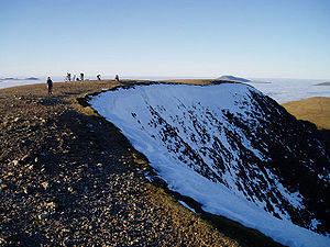
The summit plateau with the steep drop to the east |
||
| height | 950 m ASL | |
| location | Cumbria , England | |
| Mountains | Cumbrian Mountains | |
| Dominance | 14.8 km → Scafell Pike | |
| Notch height | 712 m ↓ Dunmail Raise | |
| Coordinates | 54 ° 31 '37 " N , 3 ° 1' 3" W | |
|
|
||
The Helvellyn [ hɛl'vɛ.lɪn ] is at 950 m height the third highest mountain in both the Lake District and in all of England . It belongs to the 214 Wainwright Mountains ( Fells ).
Along with Scafell Pike , Great Gable and Old Man of Coniston , the Helvellyn is one of the most famous and most climbed mountains in England. In addition to the possibility of reaching the summit by mountain bike, there is also a triathlon every year , the running route of which leads from the village of Patterdale, 5 km east, to the summit and back.
Location and description


The Helvellyn is the highest point of the Helvellyn Range , a mountain range that runs between Lakes Ullswater in the east and Thirlmere in the west and runs north with the mountains Helvellyn Lower Man , White Side , Raise , Stybarrow Dodd , Great Dodd and Clough Head and continues south with Nethermost Pike and Dollywaggon Pike .
The summit section of the Helvellyn consists of a roughly 500-meter-long, relatively flat ridge that slopes down into grassy slopes to the west, but very steep and rocky to the east. The highest point is formed by a stone column ( Cairn marked), north of it is a little lower in 949 m altitude, a measuring column of the Ordnance Survey .
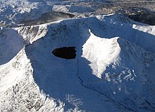
Two clearly defined ridges branch off from the summit in an easterly direction: Striding Edge to the south and Swirral Edge to the north. With the eastern slope of the Helvellyn, they enclose a basin in which the small mountain lake Red Tarn lies. Striding Edge offers one of the most famous and airiest mountain tours in the Lake District, which is still possible without technical safety. Swirral Edge connects the Helvellyn with the pyramidal Catstye Cam .
Red Tarn ( "Red Lake" ) is named after the reddish gravel on its shore. It is about 25 meters deep and offers brown trout and coregon habitats. In the middle of the 19th century its capacity was increased with a rock dam to create a water reservoir for the Greenside lead mine in the Glenridding Valley.
In Brown Cove there was a second tarn, which was also dammed by a dam built in 1860 to serve as a water reserve for the lead mine. The dam is leaking today and the tarn is gone. Remains of the water pipe that led to the lead mine can still be found on the northern slope of Catstye Cam.
The water from Red Tarn and Brown Cove flows over Glenridding Beck , which is created on the north side of the Helvellyn, into Lake Ullswater .
Striding Edge
Striding Edge is the terrain bridge from Helvellyn to Birkhouse Moor and is one of the most famous scramblings in the Lake District among mountain hikers . As scrambling climbing in the lowest level of difficulty is called, that no technical tools, but requires the use of hands. Striding Edge therefore does not offer any major technical difficulties, and rope belaying is usually not used.
The route begins at Hole-in-the-Wall , a breakthrough in a dry stone wall on the pass between Helvellyn and Birkhouse Moor, which can be seen from afar and serves as a landmark for the ascent to Helvellyn from the Grisedale. The ridge leads over a length of about two kilometers to the summit of Helvellyn. After a wider passage with a well-defined path, it becomes noticeably narrower above Nethermost Cove at the highest point at High Spying How and runs for the most part without a recognizable path over a rock ridge that slopes steeply on both sides. At the end of the ridge, after a short steep step, which can be easily climbed in a chimney, it meets the steep eastern flank of the Helvellyn, which is relatively easy to reach above. In winter, after heavy snowfall, a cornice often forms on the edge of the summit plateau , which is the biggest obstacle when climbing.
geology
The rock of the Helvellyn and the adjacent areas is partly made of pyroclastic rock in connection with tuff , breccia and lapilli . In the deeper layers can be found dacite .
There are numerous testimonies of mining activity on the west side. The Helvellyn (or Wythburn ) mine was in operation from 1839 to 1890, but was abandoned when the Thirlmere Reservoir was enlarged, especially as it did not make any significant profit.
Cultural meaning
For a long time Helvellyn was only entered by grazing shepherds with their flocks, but when a new turn to nature became important in the romantic era , poets, draftsmen and painters liked to go to the summit. William Wordsworth , one of the Lakeland poets , regularly hiked the mountain; the painter Benjamin Robert Haydon created the portrait William Wordsworth on Helvellyn .
Charles Gough
Charles Gough was a painter who explored the wild summit on his own during a visit to the Lake District in 1805, where he fell from Striding Edge into the basin of the Red Tarn on April 17 and was killed in the process. His skeleton was found by a shepherd on July 27th. Gough's dog Foxie had alerted him, she was still at the crash site and doing well. This touching example of dog loyalty is celebrated in many poems, the best known being Helvellyn by Walter Scott and Fidelity by William Wordsworth. The fact that Gough's body had almost no meat left on its bones when it was found has sparked speculation as to whether the dog was feeding on it in the barren area.
Canon Hardwick Rawnsley , founder of the National Trust , had a plaque erected in 1891 a few meters southeast of the summit, directly on the path to Striding Edge, to commemorate this incident.
Robert Dixon
A memorial stone erected in 1858, the Dixon Memorial below High Spying How, commemorates Robert Dixon , from Rooking in Patterdale, who fell to his death here on November 27, 1856 while hunting a fox .
Plane landings
John Leeming and Bert Hinkler landed and took off successfully on December 22, 1926 with an Avro 585 Gosport, a two-seater biplane, on the summit plateau after two attempts had to be broken off the week before. It was the first ever airplane landing on an English mountain. At the restart, because of the strong easterly wind, they did not gain enough speed and fell over the edge into the Red Tarn basin, but were able to take enough speed in a dive and take the return flight. A stone tablet a little south of the summit also reminds of this.
Web links
- Virtual panorama north south
- Helvellyn at English Lakes
- Helvellyn photos at The Lakeland Fells
- Round tour Helvellyn ( page no longer available , search in web archives )
Remarks
- ↑ a b Blair, Don; Exploring Lakeland Tarns , Lakeland Manor Press (2003), ISBN 0-9543904-1-5
- ↑ a b Adams, John: Mines of the Lake District Fells , Dalesman (1995); ISBN 0-85206-931-6
- ^ Woodhall, DG: Geology of the Keswick District , British Geological Survey (2000)
- ↑ Fidelity German / English
- ↑ quoted by Jonathan Jones in the Guardian on March 15, 2003, The Romantics and the myth of Charles Gough , accessed on February 3, 2018: The bitch […], shocking to relate, had torn the cloaths from his body and eaten him to a perfect skeleton.
- ↑ FIRST_Aircraft_landing_on_a_Mountain_in_GB , accessed on February 3, 2018


