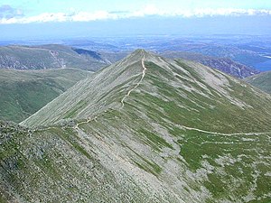
Catstye Cam
| Catstye Cam | ||
|---|---|---|
|
View from Helvellyn to Catstye Cam, the ridge on the left is Swirral Edge |
||
| height | 890 m ASL | |
| location | Cumbria , England | |
| Mountains | Cumbrian Mountains | |
| Dominance | 0.8 km → Helvellyn | |
| Notch height | 70 m ↓ Swirral Edge | |
| Coordinates | 54 ° 31 '59 " N , 3 ° 0' 32" W | |
|
|
||
Catstye Cam is one of the 214 Wainwright mountains ( Fell ) in the Lake District National Park in northern England and is assigned to the Eastern Fells as a mountain of the Helvellyn Range .
Surname
Catstye Cam is the official notation on the Ordnance Survey maps . Alfred Wainwright prefers the spelling Catstycam in his Pictorial Guide to the Lakeland Fells . A third common variant is catchedicam , which Wainwright also mentions.
When interpreting the name, it is assumed that it originated from the Old Norse names kattr , stigr and kambr and means roughly ridge / shoulder with a steep (wild) cat path .
topography

location
The mountain range called Hevellyn Range lies in a north-south direction between the lakes Ullswater in the east and Thirlmere in the west and runs from the north over the mountains Clough Head , Great Dodd , Stybarrow Dodd , Raise , White Side , Helvellyn Lower Man , Helvellyn and Nethermost Pike to Dollywaggon Pike as the southern end point.
While the west side of the mountain range consists essentially of grass-covered slopes, the east side is steep and rocky. The Swirral Edge ridge leads from the north side of the Helvellyn summit plateau in a north-easterly direction to Catstye Cam, about 900 meters away.
Appearance
Catstye Cam shows a pronounced pyramid shape from all sides: at the summit, three almost regularly distributed ridges meet, which span relatively flat flanks. Alfred Wainwright describes it as one of the most beautiful mountains in the Lake District and regrets that it does not come into its own in the shadow of its higher neighbors, "because it has almost the perfect mountain shape with a very small, narrow summit region and all around steeply sloping sides."
Despite the short connection to the higher Helvellyn through Swirral Edge , Catstye Cam still has a notch height of 70 meters, which is considerable in the Lake District.
Valleys
South of Swirral Edge lies Red Tarn in a basin, which got its name because of the red gravel surrounding it. You can find brown trout and coregon in it . In the mid-19th century, a rock dam increased its capacity to create a water reservoir for the Greenside lead mines in the Glenridding Valley .
In the northern basin of Brown Cove there was originally another lake, which also served as a water reservoir for the mines, but the dam has become permeable and therefore no longer dammed water. On the northern slopes, remains of the 19th century aqueduct can still be found, which transported the dammed water into the lead mines.
The outflowing streams from Brown Cove and Red Tarn merge at the eastern foot of Catstye Cam to form Glenridding Beck and flow into Lake Ullswater at Glenridding.
geology
At Catstye Cam you will find mainly pyroclastic rock in connection with tuff , breccia , lapilli and dacite as in the entire Helvellyn area.
Remarks
- ^ A b c Wainwright, Alfred: Pictorial Guide to the Lakeland Fells , Volume 1, The Eastern Fells
- ^ Robert Gambles, Lake District Place Names , Dalesman Books, Clapham 1985
- ↑ Blair, Don; Exploring Lakeland Tarns , Lakeland Manor Press (2003), ISBN 0-9543-9041-5
- ^ Adams, John: Mines of the Lake District Fells , Dalesman (1995); ISBN 0-8520-6931-6
- ^ Woodhall, DG: Geology of the Keswick District , British Geological Survey (2000)

