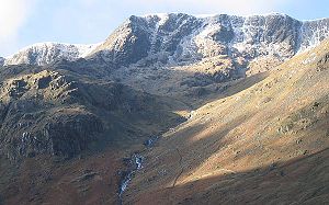
Nethermost Pike
| Nethermost Pike | ||
|---|---|---|
| height | 891 m | |
| location | Cumbria , England | |
| Mountains | Cumbrian Mountains | |
| Coordinates | 54 ° 31 '2 " N , 3 ° 1' 9" W | |
|
|
||
Nethermost Pike is one of the 214 Wainwright mountains ( Fell ) in the Lake District National Park in northern England . It is the second highest mountain of the Helvellyn Range , a north-south mountain range that lies between Ullswater in the east and Thirlmere in the west, and is assigned to the Eastern Fells .
While the west side consists of grass slopes, the east side is steep and rocky. In previous centuries, mining was here for obtaining operated by lead, and it can be found numerous existing tunnels and shafts today.
geology
The rock of the Nethermost Pike and the adjacent areas is partly made of pyroclastic rock in combination with tuff , breccia and lapilli . In the deeper layers can be found dacite .
The soil in the eastern area of the Helvellyn Range is very rich in minerals, so that fertile soil can be found there, which, together with the climate and remoteness, produces a large variety of plants that are typical of high alpine landscapes and tundras . In Nethermost Cove about a third of the English population of Lapland willow ( Salix lapponum ) can be found.
topography
The Helvellyn Range runs for eleven kilometers in a roughly north-south direction and the ridge is about 600 m above sea level. Nethermost Pike is at the southern end and is bounded by Dollywaggon Pike to the south and Helvellyn to the north . The summit, located between Dollywaggon Pike and Nethermost Pike, is called High Crag because of its low notch height by Alfred Wainwright as an independent summit of the Lake District. Most hiking guides adopt this point of view and consider High Crag to be part of the Nethermost Pike.
As with most of the other peaks of the Helvellyn Range, there is a stark contrast between the west and east sides. "The western grassy slopes, which the masses [the hikers] have climbed, are of little interest, but one should not judge the mountain prematurely. From the east it is no less magnificent than the Helvellyn."
The western grass slopes are even and not very spectacular to the top of the Thirlmere Reservoir and the small church of Wythburn. There are some more impassable and rocky places (e.g. High Crags and Comb Crags ), but they cannot tarnish the overall impression of the even and gentle grassy slopes. The lower areas have been reforested with conifers and form part of the Thirlmere Forest . Above these trees, the impression of the wide open fur is unclouded.
The appearance of the east side is completely determined by rocks. From two karen ( Corrie ) with steep rock slopes, narrow valleys lead east to the main valley Grisedale . The southern of the two is Ruthwaite Cove , in which Hard Tarn is very hidden , a small mountain lake whose clear water, together with the black rocks, gives the false impression of great depth.
Here you will also find the mountain hut called Ruthwaite Lodge , which originally belonged to the mines located here and which today serves as a starting point for mountain and climbing tours.
In the mines was galena to lead recovery encouraged. It is believed that this mining activity dates back to the 16th century. Further activities are recorded around 1784 and 1862. The last mining activity took place in 1880.
The second basin is Nethermost Cove , which is where the remains of the Eagle Crag Mine can be found.
These two valleys are separated by the rocky east ridge. Though less spectacular than Striding Edge , it offers the most rewarding route straight to the top of Nethermost Pike.
To the north, Nethermost Pike is separated from Helvellyn by the Swallow Scarth depression , which lies above Nethermost Cove.
The summit of Nethermost Pike consists of a roughly triangular, grass-covered plateau and is not very spectacular. Except for the northern area, which is dominated by the higher Helvellyn, a very large part of the Lake District can be overlooked.
Remarks
- ^ A b c Wainwright, Alfred: Pictorial Guide to the Lakeland Fells , Volume 1, The Eastern Fells
- ^ A b c Adams, John: Mines of the Lake District Fells , Dalesman (1995)
- ^ Woodhall, DG: Geology of the Keswick District ; British Geological Survey (2000)
- ↑ Blair, Don: Exploring Lakeland Tarns ; Lakeland Manor Press (2003)


