Great Glen Way
| Great Glen Way | |
|---|---|
 View from Fort Augustus over Loch Ness |
|
| map | |

|
|
| Data | |
| length | 117 km |
| location | UK, Central Scotland |
| Markers | Black stylized thistle in a hexagon on a light blue background |
| Starting point |
Fort William 56 ° 49 ′ 0 ″ N , 5 ° 7 ′ 0 ″ W. |
| Target point |
Inverness 57 ° 29 ′ 0 ″ N , 4 ° 13 ′ 0 ″ W. |
| Type | Long-distance hiking trail |
| Height difference | 375 m |
| The highest point | Between Drumnadrochit and Abriachan, 375 m |
| Lowest point | Fort William or Inverness, sea level |
| Level of difficulty | light |
| season | all year round |
| particularities | Follow the Great Glen , the central valley of the Scottish Highlands |
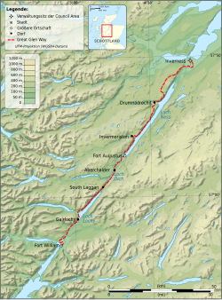
The Great Glen Way is a trekking or cycling route through the Scottish Highlands . It runs parallel to the Caledonian Canal between Fort William and Inverness , along the lakes Loch Linnhe , Loch Lochy , Loch Oich and Loch Ness . The largest lake, Loch Ness, is only partially visible, however, as the trail runs in parts on the other side of a mountain ridge. The Great Glen Way can be hiked in both directions, but it is advisable to start in Fort William and head north-east, as you usually have wind and sun behind you. In addition, you start with the easiest section and can get used to the increasing challenges.
The trail was officially inaugurated on April 30, 2002 by Andrew Mountbatten-Windsor, Duke of York , and runs for 117 km.
The route can be walked comfortably with trekking luggage in around 5 to 7 days. With very light luggage, such as when using one of the local luggage transport companies, you can cover the route in 3 to 4 days if you have good stamina.
photos
Web links
Individual evidence
- ^ Great Glen Way Introduction ( July 19, 2009 memento on the Internet Archive ), accessed August 18, 2010
- ^ Great Glen Way - Baggage and Taxi Service ( July 22, 2009 memento in the Internet Archive ), accessed August 18, 2010


