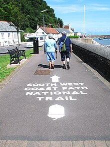
South West Coast Path
| South West Coast Path | |
|---|---|
 Dorset coast |
|
| Data | |
| length | 1014 km |
| location | south west England |
| Markers | stylized upright white acorn on a brown background |
| Starting point |
Minehead 51 ° 12 ′ 39.6 " N , 3 ° 28 ′ 24.9" W. |
| Target point |
Poole Harbor 50 ° 40 ′ 46.5 ″ N , 1 ° 57 ′ 0.5 ″ W. |
| Type | Long-distance hiking trail |
| Lowest point | Poole Harbor , sea level |
| Level of difficulty | medium |
| season | all year round |
| particularities | Longest of the UK's National Trails . Follows the coasts of Cornwall and Devon . |


The South West Coast Path is Britain 's longest signposted long distance footpath and national trail . It runs 1,014 km (630 miles) from Minehead in Somerset along the coasts of Devon and Cornwall to Poole Harbor in Dorset .
Important data
Since it rises and falls at every river mouth, it is considered a comparatively strenuous long-distance hike. The total height to be climbed was calculated to be 35,031 m (114,931 ft), almost four times the height of Mount Everest .
The last section of the trail was recognized as a National Trail in 1978. Many of the landscapes that the South West Coast Path traverses have special status, either as a national park or as a Heritage Coast . The trail passes through two UNESCO World Heritage sites: the Dorset and East Devon coast known as the Jurassic Coast was granted UNESCO World Heritage status in 2001, and the Cornwall and West Devon mining landscape in 2007.
In the 1990s it was calculated that the trail had grossed £ 15,000,000 annually for the region. Recent research in 2003 indicated annual revenues of around £ 300,000,000, which supports more than 7,500 jobs. This work also documents that 27.6% of visitors came to the area for this trail, spending £ 136 million a year there. The local population has taken 23 million walks along the way and spent an additional £ 116 million, and other visitors added the rest. Another study in 2005 estimated that number had now risen to around £ 300,000,000.
History of the path
The trail was laid out for the Coast Guard to patrol from lighthouse to lighthouse on foot while fighting smugglers. The coast guards needed to be able to look down into each bay. As a result, the path hugs the coastline and offers excellent views, but rarely a direct path between two points. The South West Coast Path is no longer used by the Coast Guard to counter smugglers, but has been transformed into an offer for recreational hikers.
The trail is covered by a public right of way , currently the Countryside and Rights of Way Act, which keeps historic hiking trails open to the public, even if they lead through private property. Sections of the trail are maintained by the National Trust, which owns portions of the coastal properties.
The trail is a designated national trail largely funded by Natural England . It was built in stages, with the final section opening in Somerset and North Devon in 1978. It is looked after by a dedicated South West Coast Path team.
The South West Coast Path Association exists to support the interests of the users of the trail. The registered association was founded in 1973 and has been trying to improve the way ever since. Services include, but are not limited to, accommodation brokerage, guides and graduation certificates.
Web links
- Official website of the trail at National Trails.
Individual evidence
- ^ South West Coast Path Association: Distance reckoner . Archived from the original on October 24, 2007. Retrieved November 25, 2007.
- ↑ a b c Countryside Agency: Coast Path is a £ 300M Money Spinner for the South West . Countryside Agency. September 25, 2003. Archived from the original on December 5, 2008. Info: The archive link was automatically inserted and not yet checked. Please check the original and archive link according to the instructions and then remove this notice. Retrieved February 1, 2008.
- ↑ UNESCO World Heritage Center: Dorset and East Devon Coast . Retrieved November 27, 2007.
- ↑ UNESCO World Heritage Center: Cornwall and West Devon Mining Landscape . Retrieved November 26, 2007.
- ^ Philip Andrews: The Countryside Agency and Regional Development Agencies . Countryside Agency. 1997. Accessed on February 1, 2008. ( Page no longer available , search in web archives ) Info: The link was automatically marked as defective. Please check the link according to the instructions and then remove this notice.
- ^ Mapping the gaps in England's coastal access . Natural England. July 31, 2009. Archived from the original on August 3, 2009. Info: The archive link was automatically inserted and not yet checked. Please check the original and archive link according to the instructions and then remove this notice. Retrieved July 31, 2009.
- ↑ This is the South West Coast Path! . In: South West Coast Path Association . Archived from the original on October 24, 2007. Retrieved November 25, 2007.

