
Speyside Way
| Speyside Way | |
|---|---|
 Path near Cromdale |
|
| Data | |
| length | 135 km |
| location | Great Britain, Eastern Scotland |
| Markers | Stylized white thistle in a white hexagon |
| Starting point |
Buckie 57 ° 41 ′ 0 ″ N , 2 ° 58 ′ 0 ″ W. |
| Target point |
Aviemore 57 ° 12 ′ 0 ″ N , 3 ° 50 ′ 0 ″ W. |
| Type | Long-distance hiking trail |
| The highest point | Aviemore |
| Lowest point | Spey Bay , sea level |
| Level of difficulty | easy to medium |
| season | all year round |
| particularities | Follow the Spey Valley and cross Speyside , Scotland's premier whiskey region. |
The Speyside Way is one of the four official national long-distance footpaths in Scotland, including the West Highland Way , the Southern Upland Way and the Great Glen Way .
History and characteristics
The trail was opened in 1981 and runs from Spey Bay to Ballindalloch . A route to Tomintoul was added in 1990. The northern extension of the route from Spey Bay to Buckie was realized in 1999. The last section, which was completed in April 2000, connects Ballindalloch and Aviemore . Since then, the Speyside Way has been running from the Moray Coast to the foothills of the Grampian Mountains and mostly follows the valley of the River Spey and in large parts the course of the disused Strathspey Railway .
The Speyside Way Ranger Service , which is based in Aberlour , looks after the entire route and ensures that the route is kept in order and, if necessary, repaired.
The path offers easy hiking trails in flat terrain and varied landscapes: the coast, the Spey river valley and Scottish moorland.
The entire distance including the stage to Tomintoul is 135 km.
Speyside whiskey region
Some of the famous Scottish Whiskey - Distilleries are right on track. For example Aberlour , Cragganmore , Craigellachie , Glenlivet , Macallan or Tomintoul .
photos

Buckie Harbor

Former stop of the Strathspey Railway
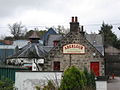
Aberlour whiskey distillery

On the banks of the Spey

Old railway underpass

Signage on Speyside Way


literature
- Hartmut Engel: Scotland: Speyside Way - Whiskey Trail. 4th edition. Conrad Stein Verlag, 2011, ISBN 978-3-86686-043-8 .