
Pembrokeshire Coast Path
| Pembrokeshire Coast Path | |
|---|---|
 Path between New Gale and Solva |
|
| Data | |
| length | 300 km |
| location | Wales |
| Markers | stylized upright white acorn on a brown background |
| Starting point |
Poppit Sands at St. Dogmaels 52 ° 4 ′ 55 ″ N , 4 ° 40 ′ 58 ″ W |
| Target point |
Amroth , Pembrokeshire 51 ° 43 ′ 53.6 " N , 4 ° 39 ′ 48" W. |
| Type | Long-distance hiking trail |
| Height difference | 175 m |
| The highest point | Pen yr afr, 175 m |
| Lowest point | Sandy Haven, sea level |
| Level of difficulty | light |
| season | all year round |
| particularities | Follow the Welsh coast. |

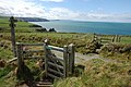
The Pembrokeshire Coast Path ( Welsh Llwybr Arfordir Sir Benfro ), often also referred to as the Pembrokeshire Coastal Path , is one of the official long-distance hiking trails in the United Kingdom ( National Trail ) in Pembrokeshire in south-west Wales . It was established in 1970, is almost 300 km long and runs mainly on the upper edge of the local cliffs along the Welsh coast. Even if the coastline is mainly oriented to the west, the many bays along the way give you vantage points in almost every direction.
The southern end of the trail is in Amroth , Pembrokeshire , and the northern end is usually indicated at Poppit Sands near St. Dogmaels in Pembrokeshire, where there was originally an official start marker. In 2009 the path was extended to St. Dogmaels, where there is now a new start marker.
history
Soon after the Pembrokeshire Coast National Park was established in 1952 , Welsh naturalist and author Ronald Lockley suggested a route along the coast for a hiking trail. Although there were some settlements along the coast, communication between them was mainly by boat and access to the coast was generally not very easy. Lockley submitted his report in 1953, and his suggestions were welcomed and largely accepted by the relevant authorities. For some of the planned sections of the route there was a public right of way , but most of the route led over private land, so that extensive discussions had to be held with the landowners first. To this day, the results influence the course of the route, which deviates from the obviously best connection in some places where the landowners did not agree to a route across their land.
The construction of the hiking trail took over 17 years, during which more than 100 pedestrian bridges and more than 450 passages over fences, as well as thousands of steps in steep or slippery sections were built. After the opening on May 16, 1970, the total route length was given as 180 miles , but this no longer corresponds to the current length due to multiple route changes.
Route
The Pembrokeshire Coast Path runs almost entirely within the national park and is constantly oriented towards the coast. It is usually divided into 15 daily stages with the following endpoints:
- (St. Dogmaels to) Newport , 16 mi. Considered the most difficult stage of the route due to the length and the frequent steep climbs.
- Fishguard , 12 mi
- Pwell Deri , 9 miles
- Porthgain , 12 mi
- Whitesands , 10 miles. Exhausting and very rough stage, characterized by high cliffs and basalt rocks .
- Solva , 20.9 km. The stage circles the village of St Davids .
- Broad Haven , 12 mi. Very hilly stage.
- Martin's Haven , 11 mi. Almost the entire stage is on the cliff of the red sandstone cliffs.
- Dale , 10 mi. Flat route over the Marloes peninsula with a view of the offshore bird islands.
- Neyland , 16.4 mi. The stage leads along the north side of Milford Haven and has a point that is onlypassableat low tide .
- Angle , 16 miles. Characterized by the city of Pembroke and the industrial settlements at Milford Haven .
- Freshwater (W) , 10 mi. Suspended, lonely and demanding stage.
- Broad Haven (S) , 10 mi. The stage leads over a disused military training area and around the Castlemartin shooting range that is still in use .
- Skrinkle Haven , 11 mi. Some of the national park's most famous beaches can be found on this stage.
- Amroth , 14 miles. The stage, which is well developed for tourists, also leads through the seaside resort of Tenby and offers beautiful views of Caldey Island .
Since the coastal path is now easily accessible in dozens of places, it is used by many hikers as part of day tours to Dinas Island . The very large range of bus connections that are specially tailored to the needs of hikers also contributes to this.
nature
The rocks in the landscape are very old; there are hardly any rocks that are younger than 250 million years. Today's coastline is a result of the weathering and deformation of these ancient rocks under the influence of the sea, rivers and the last ice ages . The oldest Precambrian rocks are found in the northern part of Pembrokeshire. These date back to before the Caledonian mountain formation and are often of volcanic origin. Younger rocks formed by sedimentation shape the southern Pembrokeshire.
In spring and summer, many species of coastal flowers can be seen along the way, as well as a large number of different bird species. On many steep stretches of coast there are colonies of seabirds and uninhabited, offshore islands such as Skomer , Skokholm and Grassholm serve as an ideal habitat for them. The largest marine life near the coast are seals, porpoises and porpoises .
Archeology and landmarks
Remains of Stone Age cromlechs (stone rings or dolmens ) can be found along the way as well as signs of Bronze Age settlement. The most impressive witnesses of earlier cultures, however, are the more than 2000 year old Iron Age coastal fortresses , of which the route passes almost 60 pieces (e.g. Porth-y-Rhaw south of Nine Wells). One of the best preserved is near Solva .
Early medieval cemeteries have been found at St. Brides and in West Angle, and at Newport there are still remains of earthworks from the same period.
In the immediate vicinity of the path are barrows (such as Carreg Coetan Arthur ), Manorbier Castle and Carew Castle , the city of St. Davids with the Cathedral of St Davids and the city of Pembroke with the castle Pembroke Castle . On the site of the Castlemartin shooting range, there is a chapel, St. Govan's Chapel, between the rocks .
Awards
At St. Dogmaels, the route turns into the Ceredigion Coast Path , which follows the coast further north. The Pembrokeshire Coast Path is part of the 1,400 km long Wales Coast Path which runs the entire Welsh coast from Chepstow to Queensferry .
In 2011 National Geographic magazine named the Pembrokeshire coastline one of the most beautiful coastal areas in the world. Many of the beaches along the trail have received local awards, with 39 stretches of beach recommended by the Marine Conservation Society as of 2011 .
Picture gallery

Start marking at St. Dogmaels

View from the path to the Marloes peninsula

Poppit Sands at the north end of the trail
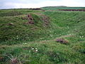
Wall remains of an Iron Age Promontory Fort , near Pwll Caerog

Dolmen Carreg Sampson
Close to Ceibwr Bay


See also
literature
- Brian John: Pembrokeshire Coast Path. New edition. Aurum Press Ltd., London 2012, ISBN 978-1-84513-782-3 .
- Ingrid Retterath, Frank Wendler: Wales: Pembrokeshire Coast Path (= OutdoorHandbuch. Vol. 242, The way is the goal ). Stein, Welver 2011, ISBN 978-3-86686-242-5 .
Web links
- Pembrokeshire Coast Path on the National Trails home page.
- www.geograph.co.uk Photographs from the Pembrokeshire Coast Path .
- newportpembs.co.uk Article on the Pembrokeshire Coastal Path on the Newport Parish home page.
Individual evidence
- ^ Pembrokeshire Coast National Trail website.Retrieved March 1, 2012.
- ^ National Trail website.Retrieved September 21, 2012.
- ↑ Photo of the old start marker. Retrieved October 16, 2012.
- ↑ www.visitpembrokeshire.com - Coastal Path - Newport to Poppit section Retrieved December 17, 2012.
- ↑ National Trail - Pembrokeshire Coast. Retrieved December 17, 2012.
- ↑ Stages on the homepage of the trail. Retrieved December 13, 2012.
- ^ Description of the geology on the homepage of the Pembrokeshire Coast Path. Retrieved October 16, 2012.
- ↑ flora and fauna on the homepage of the Pembrokeshire Coast Path. Retrieved October 15, 2012.
- ^ Archeology on the Pembrokeshire Coast Path homepage. Retrieved October 18, 2012.
- ↑ BBC News - Coast Path moves a step closer at St Dogmaels. Retrieved October 18, 2012.
- ↑ www.nationaltrail.co.uk - news article ( Memento of the original from June 28, 2011 in the Internet Archive ) Info: The archive link was inserted automatically and has not yet been checked. Please check the original and archive link according to the instructions and then remove this notice. Retrieved September 26, 2012.
- ↑ www.WalesOnline.co.uk - Accolade of being one of world's top trails . Accessed September 26, 2012.
- ↑ VisitWales.co.uk - Pembrokeshire beaches. Retrieved September 26, 2012.