Caldey Island
| Caldey Island | ||
|---|---|---|
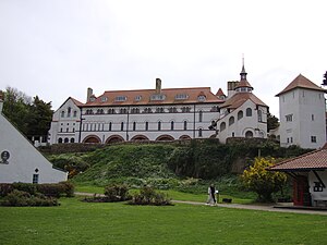
| Caldey Abbey | ||
| Waters | Bristol Channel / Celtic Sea | |
| Geographical location | 51 ° 38 '10 " N , 4 ° 41' 28" W | |
|
|
||
| length | 2.4 km | |
| width | 1.6 km | |
| surface | 2.14 km² | |
| Highest elevation | 183 m | |
| Residents | 40 19 inhabitants / km² |
|
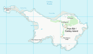
| Map of Caldey Island | ||
Caldey Island ( Welsh : Ynys Bŷr ) is an island off the south coast of Wales . The Vikings called the island Keld-ey , which means source island . It is located south of Tenby , on the western edge of Carmarthen Bay in Pembrokeshire and is about 3.7 km from the mainland. On the 2.4 km long and 1.6 km wide island, there is only one small village known for its monastery .
history
Around 525 AD a monastery was built on the island by Celtic monks under St. Illtud. Here also lived St. Samson , who came from Llanilltud Fawr. From 1136 until the expulsion in 1536 there was a pin of the Benedictines . Since 1906 there is a monastery of the Trappists ( Cistercians of strict observance) on the island.
Attractions
On the island there is
- a Norman chapel from the 12th century ,
- an ogham stone from the 6th century. It is of great interest to archaeologists as it originates from the Dark Ages . The "Caldey stone" bears an incised cross and both an Ogham and a Latin inscription. The Ogam text seems to say that “Magl Dubr” or “Prince Dyfrig” who is believed to be St. Dyfrig, the Bishop of Glywysing in Gwent, raised donations for the island in the 6th century. The Latin inscription may be later. It reads: “And I have marked this stone with the sign of the cross. I ask all who come to this place to pray for the soul of Cadwgan ”. A Cadwgan ap Bleddyn (1051–1111) was Prince of Powys in east Wales.
- the lighthouse completed in 1829 ( Caldey Lighthouse ).
- in the southwest a tumulus .
- the Trappist Abbey of Caldey Abbey
- the beaches of Eel Point, Nanna's Cave , Potter's Cave, and Skull Cave.
tourism
Boats run daily to the island from Tenby during the summer months. The island earns most from tourists. The monastery offers the opportunity to treat yourself to some rest.
Following the example of Lundy Island , the monastic community of the island issued its own postage stamps in the DAB currency from 1973 to the 1980s, which do not replace the usual transport fee. DAB is named after a small flatfish that can be found on the beaches. In earlier times, fish was the islanders' staple food. The proceeds were used for the maintenance of the monastic buildings on the island. Even after the 1980s, other stamp motifs can still be bought as souvenirs (status: 2011). The stamps have a value of 2 DABS and cost £ 0.10 (as of 1996) to provide financial support for transport to the mainland and the island's post office.
Web links
- Official website of the island
- Pictures and description of the Ogham Stone from Caldey Island - in English
- Picture of the monastery with description - in English
Individual evidence
- ^ A b c Stella Barratt: Caldey Island - "Island of Saints". In: Temple - Vol. 1. No.1 (members' magazine). Grand Priory of England and Wales, 1996, archived from the original on January 2, 2003 ; Retrieved February 3, 2000 (English, First 'all English' version of the member's journal "Temple" published by the Grand Priory of Spain).
- ^ Robin F. Heath, John F. Michell: The Lost Science of Measuring the Earth: Discovering the Sacred Geometry of the Ancients . Adventures Unlimited Press, 2006, ISBN 978-1-931882-50-7 , page 53 (English, google.de [accessed January 10, 2018]).
- ↑ a b c d Britain's Local Stamps . In: Warners Group Publications Plc. (Ed.): Stamp & Coin Mart . October 11, 2011, ISSN 0956-6627 (English, online [accessed January 10, 2018]).


