
Pennine Way
| Pennine Way | |
|---|---|
 Pennine Way near Marsden |
|
| Data | |
| length | 429 km |
| location | Northern england |
| Starting point |
Edale 53 ° 22 ′ 13.5 ″ N , 1 ° 49 ′ 0.5 ″ W. |
| Target point |
Kirk Yetholm 55 ° 32 ′ 49.5 " N , 2 ° 16 ′ 31.5" W. |
| Type | Long-distance hiking trail |
| The highest point | 893 m ( Cross Fell ) |
| Level of difficulty | medium |
| season | all year round |
The Pennine Way (German: Penninen-Weg) is a long-distance hiking trail in England that crosses the Pennines from south to north.
description
It has a length of 429 kilometers and extends from Edale ( Derbyshire ) in the Peak District through the Yorkshire Dales and Northumberland National Park . It ends at Kirk Yetholm just across the border with Scotland. Together with Hadrian's Wall Path and the West Highland Way , the Pennine Way is one of the most popular routes in Great Britain. It is also the second longest of the developed hiking trails in the United Kingdom after the South West Coast Path .
The Pennine Way runs through very sparsely populated areas. Sometimes there are few or no places to stop for refreshments during the daily stages, and there are also few places to stay. The path is sometimes very exposed, in bad weather conditions it is a difficult hiking trail.
There is no dense trail marking, so that hikers sometimes have to rely on a map and compass. Accommodation is available in smaller hotels, youth hostels and bed-and-breakfast accommodation.
history
The long-distance trail was an idea of journalist Tom Stephenson , who took similar trails in the United States, particularly the Appalachian Trail , as a model. Stephenson published his plan in the Daily Herald in 1935 and lobbied Parliament. The last leg of the trail opened at Malham in 1965 .
Route
- Clapper bridges

Signposts in Keld at the intersection with the Coast to Coast Walk (no signposts, bridleway on the right)

Children scout
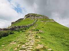
Ascent from the south to Pen-y-ghent
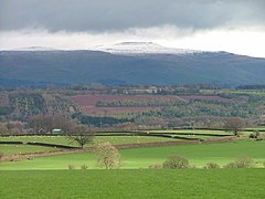
Cross Fell , the highest point of the Pennine Way

Step stones on the Hunder Sike


The Pennine Way passes the following places:
- Edale
- Children scout
- Bleaklow
- Black Hill
- Saddleworth Moor
- Standedge
- Littleborough
- Stoodley Pike
- Death murders
- Hebden Bridge
- Wadsworth Moor
- Keighley Moor
- Elslack Moor
- Lothersdale
- Settle
- Malham
- Fountains fur
- Pen-y-ghent
- Horton in Ribblesdale
- Dodd Fell Hill
- Hawes
- Great Shunner fur
- Kisdon
- Kisdon Force
- Keld (this is where the Coast to Coast Walk is crossed)
- Tan Hill
- Cauldron Snout
- Crossing the A66
- Middleton-in-Teesdale
- High cup
- Great dun fur
- Cross fur
- Alston
- Halt whistle
- Hadrian's Wall
- Shitlington Crags
- Windy Gyle
- The Cheviot
- Kirk Yetholm
literature
- Alfred Wainwright : Pennine Way Companion. A Pictorial Guide. Revised edition. Frances Lincoln, London 2004, ISBN 0-7112-2235-5 .