
West Highland Way
| West Highland Way | |
|---|---|
 The West Highland Way south of Fort William |
|
| Data | |
| length | 154 km |
| location | Great Britain, western Scotland |
| Markers | Stylized white thistle in a white hexagon |
| Starting point |
Milngavie near Glasgow 55 ° 57 ′ 0 ″ N , 4 ° 19 ′ 0 ″ W |
| Target point |
Fort William 56 ° 49 ′ 0 ″ N , 5 ° 7 ′ 0 ″ W. |
| Type | Long-distance hiking trail |
| Height difference | 584 m |
| The highest point | Devils Staircase, 584 m |
| Lowest point | Kinlochleven, sea level |
| Level of difficulty | medium |
| season | all year round |
| Viewpoints | Devils Staircase, Conic Hill; available as own day tours Ben Lomond and Ben Nevis |
| particularities | Scotland's first official long-distance footpath |
The West Highland Way is a Scottish long-distance footpath from Milngavie near Glasgow to Fort William .
The route begins in the Lowlands and leads into the Highlands , past Scotland's largest freshwater lake, Loch Lomond , touches the entrance to the valley of Glen Coe and ends not far from the highest mountain in Scotland, Ben Nevis . The total length of the hike is 154 km. The trail is jointly managed by the Highland Council and the Loch Lomond & Trossachs Interim Committee . An average of 50,000 hikers are en route every year. Depending on the stage division, the entire route usually takes six to nine days.
history
The first plans for the long-distance hiking trail were made in the 1930s. The success of the Pennine Way fueled the Scottish plans. With the Countryside (Scotland) Act passed in 1967, the necessary legal basis for the establishment of long-distance footpaths in Scotland was created. In 1974 the establishment and concrete planning of the path was approved. It was officially opened on October 6, 1980 by Lord Mansfield , then Secretary of State in the Scottish Office . In the years that followed, the route was expanded at various points and the road sections that were initially used were replaced by new routes off the road, for example between Balmaha and Rowardennan .
The West Highland Way

Route description
For the most part, the route extends over many old traffic routes, mostly cattle dealer routes, military roads and old makeshift routes. Traditionally, many people walk the route from south to north. The reason for this lies in the constantly increasing landscape, but also in the fact that the sun does not dazzle in this way. There are some campsites , makeshift campsites with no bathroom facilities, bed and breakfasts , hostels and hotels along the route . Camping outside of campsites is generally permitted in Scotland under certain conditions, but the part of the trail that is in Loch Lomond and the Trossachs National Park is subject to time and location restrictions.
The starting point of the West Highland Way is the Obelisk in the pedestrian area of Milngavie , a suburb of Glasgow . However, it leads very quickly into open terrain. Later along the route, the hiker reaches Conic Hill via dirt roads and a disused and dismantled railway line through Queen Elizabeth Forest Park , before reaching Balmaha and Loch Lomond. From here the path leads about 40 kilometers along its eastern bank to Inverarnan. On this section, the route is very demanding for a few kilometers, as the West Highland Way is run as a riverside path and is badly affected by erosion. The riverside path between Rowardennan and Inversnaid has therefore been closed since 2012. A revised low route has been reopened since 2016 and is the new official route. The easy High Route, as a simpler alternative, a forest path above the bank, is still accessible, but no longer signposted.
After Inverarnan, the path leads slightly up through Glen Falloch to the watershed of Strathfillan . There it runs a little above Crianlarich , which is the first somewhat larger town after Drymen and can be reached on a short branch. The path then follows the Strathfillan to Tyndrum . From there it runs below the Beinn Dorain to Bridge of Orchy . West of Bridge of Orchy, the path reaches the settlement of Inveroran on the banks of Loch Tulla and then crosses Rannoch Moor to Kings House Hotel along the old road laid by Thomas Telford , which has not been used for car traffic since 1932. The most mountainous part of the route begins at the entrance to the Glen Coe valley to the west of Kings House . The path climbs up the Devil's Staircase , the highest point of the route, in a steep ascent , before descending steeply to Kinlochleven again . The last stage touches the Mamore Mountains on an old military road and leads down into Glen Nevis . From there it is only a few kilometers to Fort William, some of which lead along a busy road. In Fort William, the official end point of the route was moved in 2010 from the entrance to the town to the end of the busy shopping street and pedestrian zone.
On the last part of the route, the highest mountain in Great Britain , Ben Nevis , comes into focus and is climbed by some hikers as the end of the tour.
In general, the path is well signposted and can hardly be missed. The West Highland Way does not pose too much of a challenge to the hiker, it has only a few clear inclines, for example on Conic Hill and between Kings House Hotel and Kinlochleven. Nevertheless, on some stages, especially on the Devil's Staircase and along Loch Lomond between Rowardennan and Ardleish, there should be a minimum of surefootedness, as there is sometimes a risk of slipping in wet weather. In unfavorable weather conditions, the sections over Rannoch Moor and Devil's Staircase as well as from Kinlochleven to Fort William are particularly demanding due to the lack of weather protection.
The popularity of the trail has led to various companies offering baggage transfer services for the transport of larger items of luggage, so that the trail can also be completed with little or no luggage. Complete packages with pre-booked accommodation are also offered.
The West Highland Way runs for long stretches just a few kilometers from the A82 and the West Highland Line . Many of the points established as stage destinations can be easily reached by bus or train and the route can be hiked in stages.
Stages

The locations are listed from south to north, with the respective distance from the starting point in Milngavie. Most hikers cover two to three of the stages a day.
- Milngavie
- Carbeth ; 8 km (5 mi)
- Drymen ; 19 km (12 mi)
- Balmaha , Loch Lomond; 30 km (19 mi)
- Rowardennan , Loch Lomond; 44 km (27 mi)
- Inversnaid , Loch Lomond; 54 km (34 mi)
- Inverarnan
- Crianlarich , 75 km (47 mi)
- Tyndrum , 85 km (53 mi)
- Bridge of Orchy , 95 km (59 mi)
- Inveroran , 99 km (62 mi)
- Kings House Hotel , 115 km (71 mi)
- Kinlochleven , 130 km (81 mi)
- Fort William , 154 km (95 mi)
West Highland Way Race
Since 1986 - after an unofficial run by the two initiators the year before - the West Highland Way Race has been held, an ultramarathon over the entire distance. It starts shortly after midnight on the morning of the longest day of the year. The participants cover the route from Milngavie to Fort William non-stop. In 2017 Rob Sinclair set the current course record with 13:41:08 hours. The female record holder has been Lucy Colquhoun since 2007 (17:16:20 h).
Photographs

Start marker in Milngavie

Loch Lomond between Inversnaid and Inverarnan
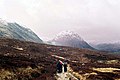
Walk towards Glen Coe
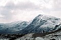
Devil's staircase

End marking in Fort William by 2010


literature
- Hartmut Engel: Scotland: West Highland Way , 9th edition 2016, ISBN 978-3-86686-371-2
- Charlie Loram: West Highland Way , ISBN 1-873756-54-2
Web links
- West Highland Way official website
- West Highland Way race
- Information, pictures and directions for the West Highland Way
- Maps and lots of pictures of the West Highland Way
- Information and stage descriptions on the West Highland Way
Individual evidence
- ↑ Terry Marsh: The West Highland Way: From Milngavie to Fort William Cicerone Press Limited, March 1, 2003, p. 10
- ^ A b West Highland Way Race: History , accessed February 9, 2015
- ^ Conditions for "wild camping" according to the Scottish Outdoor Access Code . Retrieved June 6, 2018.
- ↑ Regulations for camping within the national park for 2017. Accessed on June 6, 2018.
- ^ The West Highland Way - Official website of Scotland's premier long distance route: The Route , accessed February 9, 2015
- ^ Website of the West Highland Way Race