
South Downs Way
| South Downs Way | |
|---|---|
 Path on the coast at Beachy Head |
|
| Data | |
| length | 160 km |
| location | southern England |
| Markers | stylized upright white acorn on a brown background |
| Starting point |
Winchester 51 ° 3 ′ 41 ″ N , 1 ° 18 ′ 33 ″ W. |
| Target point |
Eastbourne 50 ° 45 ′ 6.9 ″ N , 0 ° 16 ′ 2 ″ E |
| Type | Long-distance hiking trail |
| Height difference | 270 m |
| The highest point | Butser Hill, 270 m |
| Lowest point | Eastbourne , sea level |
| Level of difficulty | light |
| season | all year round |
| Viewpoints | Butser Hill, Ditchling Beacon, Beachy Head |
| particularities | Follow the ridge of the South Downs range of hills |
The South Downs Way is a walking and public bridle path in the south of England . The trail crosses South Downs National Park from Winchester in Hampshire to the seaside resort of Eastbourne in East Sussex . It is one of the " National Trails " and thus part of the system of official long-distance hiking trails in Great Britain.
course
The 100 mile (160 km) long trail runs primarily through the rolling hills of the South Downs . Despite the dense population of southeast England, he bypasses the larger towns along the route such as Brighton and Lewes . There are numerous scenic attractions along the way such as Ditchling Beacon , Devil's Dyke , the Long Man of Wilmington , the Seven Sisters and Beachy Head .
Between Winchester and the Cuckmere village of Alfriston , the trail and bridle path follow the same route. From there, the bridle path (which cyclists can also use) leads inland via Wilmington to Eastbourne, while an alternative route for pedestrians only follows the course of the river to the Cuckmere Estuary and then via the Seven Sisters and past Beachy Head to Eastbourne beach.
Photographs
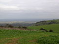
View from Ditchling Beacon

literature
- Paul Millmore: South Downs Way (= National Trail Guide. 12). Revised edition. Aurum Press, London 2008, ISBN 978-1-84513-311-5 .
Web links
- Official website of the trail at National Trails.