Appalachian Trail
| Appalachian Trail | |
|---|---|
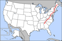
 Map of the Appalachian Trail |
|
| Data | |
| length | approx. 2200 mi (3500 km ) |
| location | Appalachian Mountains |
| Supervised by | Appalachian Trail Conservancy |
| Type | Long-distance hiking trail |
| The highest point | Clingmans Dome (2025 m) |
| Lowest point | Bear Mountain State Park (38 m) |
| season | Spring to autumn |
| Months | March to October |

The Appalachian Trail ( AT , English for Appalachian Trail ) is an approximately 3500-kilometer long- distance hiking trail of the National Trails System . Its official name is the Appalachian National Scenic Trail . It runs through the US Appalachian Mountains, its endpoints are Springer Mountain in Georgia and Mount Katahdin in Maine . The AT crosses 14 US states : Georgia, North Carolina , Tennessee , Virginia , West Virginia , Maryland , Pennsylvania , New Jersey , New York , Connecticut , Massachusetts , Vermont , New Hampshire and Maine.
The Appalachian Trail is well known by hikers, some of whom attempt to hike the entire route in one season. They are called "thru-hiker".
Along with the Pacific Crest Trail (PCT) and the Continental Divide Trail (CDT), the hiking trail is one of the three triple crown trails. Hikers who have walked all three paths in the course of their lives receive the “Triple Crowner” award.
history
The path has no historical origins such as the Pony Express , Chilkoot Trail or old Indian trails.
Around 1900 there were some hiking clubs, especially in the New England states (e.g. the Appalachian Mountain Club). The idea of a coherent path was published by Benton MacKaye in 1921 . Hostels, nature protection stations and even self-sufficient communities were to be built along the way. In 1925 the Appalachian Trail Conference (ATC) was founded as a non-profit organization that still exists today . The goal at that time was to connect the highest points in the east: Mount Mitchell at 2037 m and Mount Washington at 1917 m. Hiking clubs quickly took up MacKaye's idea, and in 1922 volunteers laid the first kilometers of the trail around Bear Mountain . In 1925, the Appalachian Trail Conference was held to further promote the project . The distance increased steadily, especially under ATC chairman Myron H. Avery. The official opening took place on August 14, 1937, but without arousing exceptional interest.
In 1948 Earl Shaffer was the first to hike the Appalachian Trail within one season, a so-called thru-hike, he hiked from Georgia to Maine, ie "north bound". Later he also did this in the opposite direction, making him the first hiker to hike the AT in both directions. 50 years after his first thru-hike, at almost 80 years old, Earl Shaffer repeated his thru-hike. That makes him the oldest thru-hiker on the Appalachian Trail.
Flora and fauna
The Appalachian Trail is full of rare plants and animals, and there are over 450 rare and endangered species along the way.
Animals
The Appalachians belong to the range of the American black bear , but this is considered less dangerous than the grizzly bear . Although encounters with humans are rare, it is recommended that food be stowed in a bear-proof canister on the trail and kept out of the reach of bears at night. Several species of venomous snakes are native to the trail, including the forest rattlesnake and the North American copperhead . Both are more likely to be found in dry, rocky sections of the trail. Large mammals on the trail, which can be seen often, are deer , elk and moose , which, in all New England states most common in Massachusetts may be encountered. For most hikers, ticks , mosquitoes and " black flies " are the biggest nuisance. Mice can often be found in the refuges.
plants
The vegetation changes depending on latitude and altitude. In the south, the forest is dominated by hardwoods such as oak , tulip trees and chestnuts , which are replaced by beeches , maples and birches in the north , and there are also occasional conifers .
topography
There is no subalpine vegetation between Mount Rogers , Virginia and Mount Greylock , Massachusetts , mainly because the trail between Shenandoah National Park and Mount Greylock, Massachusetts does not exceed 3000 ft. (910 m). However, there are extensive sub-alpine regions at Mount Greylock. At Mount Moosilauke (1464 m) one encounters alpine vegetation for the first time, this is generally found between 1300 and 1500 m in the northern Appalachians. Along the Franconia Ridge and the Presidential Range the trail runs 21 km above the tree line , in the area of the Presidential Range Trail it touches the summit of Mount Washington at an altitude of 1917 m. In Maine, the trail crosses even more inhospitable regions. Alpine vegetation can be found here in parts of the Hundred-Mile Wilderness from a height of 300 m.
Hiking the trail
The purchase of around 70 m of land on both sides of the path contributed to the special character, so that almost the entire path is publicly owned. It is part of the National Scenic Trails and is managed by the National Park Service in collaboration with local organizations. The path was built specifically for hiking, so there are supply and disposal options along the way.
Orientation and marking
The Appalachian Trail is marked by white color markings along its entire length, these are approx. 5 cm (2 in ) wide and approx. 15 cm (6 in) high. Side paths, alternative routes, viewpoints and parking lots are marked with similar blue color markings. In the past, some sections of the trail were marked with metal diamonds, which were provided with the AT logo; today there are only a few of these old markings left.
Typical white marker in Pennsylvania
Example of blue paint marking an alternative route at Mount Greylock , Massachusetts
Accommodation options

Most hikers carry a light tent , a hammock or a tarp with them, so they are on the move with the lowest possible weight, as this reduces the effort and thus greater distances can be covered during the day.
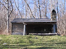
The shelters, called “shelter” or “lean-tos”, offer an alternative to sleeping in tents. Mostly they are simple wooden huts with wooden floors, which are open on the side facing away from the weather. Nearby there is usually a fire pit and space to pitch tents, for hikers who prefer the tent, or when the shelter is already full. Shelter often also have an outhouse nearby . There are more than 250 refuges and camping sites on the Appalachian Trail. There are also occasional hotels and hostels along the way near localities .
Villages on the trail
The trail crosses many roads and offers hikers so many opportunities to hitchhike to nearby towns . The local drivers mostly know that the hitchhikers are hikers of the AT and like to take them with them, the trail also crosses many villages. This gives hikers regular opportunities to replenish their supplies or buy new equipment.
route
The Appalachian Trail crosses 14 US states : Georgia , North Carolina , Tennessee , Virginia , West Virginia , Maryland , Pennsylvania , New Jersey , New York , Connecticut , Massachusetts , Vermont , New Hampshire, and Maine .
The section through Pennsylvania is also called "Rocksylvania" by hikers because the path here is very stony and hard.
See also
Other long-distance hiking trails in the USA
media
Movies
In 2015, the film came out with a picnic with bears, starring Robert Redford and Nick Nolte . The film is based on the book of the same name by Bill Bryson .
literature
- Bill Bryson : picnic with bears . Goldmann, 2008, ISBN 978-3-442-44395-6 .
- David Miller: AWOL on the Appalachian Trail. Lake Union Publishing, 2010.
- Bill Irwin: Dark Night on Bright Day - A blind man on the Appalachian Trail. Goldmann, Munich 1995, ISBN 3-89405-099-3 .
Web links
- Through the wilderness of America - 3000 kilometers on foot in the Internet Movie Database (English): youtube
- appalachiantrail.org
- fastpacking.de: Appalachian Trail (AT) - From Georgia to Maine
- theatguide.com
Individual evidence
- ↑ washingtonpost.com
- ↑ aldhawest.org
- ^ Paul R. Lehman: Blue Mountain Eagle Climbing Club - Keepers of the Appalachian Trail. Historical Society of Berks County, accessed December 4, 2015 .
- ↑ John Gattuso, Martha Ellen Zenfell (ed.): Usa - National Parks East. Apa Guides, Langenscheidt, 1996, ISBN 3-8268-1447-9 , p. 55.
- ↑ americanhistory.si.edu
- ^ Earl V. Shaffer: Walking With Spring. 2004, ISBN 0-917953-84-3 .
- ↑ nytimes.com
- ↑ appalachiantrail.org
- ↑ a b c Through the wilderness of America - 3,000 kilometers on foot on the Appalachian Trail (part 1 + 2) (documentary). on: youtube.com
- ↑ http://www.appalachiantrail.org/home/explore-the-trail/trail-updates accessed on January 18, 2016.
- ↑ Colorful Climbs
- ↑ appalachiantrail.org
- ↑ https://www.youtube.com/watch?v=expjsUj9dZo The Appalachian Trail, National Geographic
- ↑ http://appalachiantrials.com/whats-pack-gear-survey-2014-appalachian-trail-thru-hikers/ What's In Your Pack ?: A Gear Survey of the 2014 Thru-Hikers
- ^ T. Edward Nickens: Bed and Breakfast. In: Smithsonian Magazine. 32 (4), July 2001, p. 24
- ↑ post-gazette.com


