Continental Divide Trail

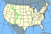
The Continental Divide Trail (abbreviated CDT , English for main watershed path ) is a 5,000-kilometer long- distance hiking trail along the North American continental watershed from the Mexican to the Canadian border. It is one of the 1968 National Scenic Trails of the USA and was officially designated on November 10, 1978.
The hiking trail, made up of specially designated paths and smaller roads, was around 76% completed in 2018. On the unfinished parts, you have to find your own way through the terrain or hike on roads.
Only around 200 people try the entire route every year (so-called thru-hiker ) and it takes around six months. Most of them start in April in southwest New Mexico and hike north ( northbounders ), others begin their hike south ( southbounders ) in mid-June or early July in Glacier National Park on the Canadian border , depending on the weather .
In addition to the Appalachian Trail and the Pacific Crest Trail , the CDT is one of the so-called Triple Crown trails. Hikers who have walked all three paths in the course of their lives call themselves “triple crowner”.
route
The trail crosses five US states (north to south): Montana , Idaho , Wyoming , Colorado, and New Mexico . Several national parks are crossed. Some examples:
New Mexico
Colorado
- Grays Peak
- Mount Elbert and Mount Massive - Colorado's highest peaks
- Rocky Mountain National Park
Wyoming
literature
- Stephen Pern: On foot through North America - along the great watershed from New Mexico to Canada . Verlag Frederking & Thaler 2001, ISBN 3-89405-046-2
- Christine Thürmer: Running. Eat. Sleep. Malik publishing house, ISBN 978-3890294711
Web links
- CDT Society (English)
- CDT Coalition (English)
