Mount Greylock
| Mount Greylock | ||
|---|---|---|
|
Mount Greylock |
||
| height | 1064 m | |
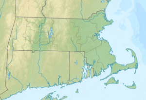
| location | Massachusetts , United States | |
| Mountains | Taconic Mountains | |
| Coordinates | 42 ° 38 ′ 13 ″ N , 73 ° 9 ′ 3 ″ W | |
|
|
||
| Type | Thrust | |
| rock | Phyllite , marble | |
| Age of the rock | Ordovician , Taconic Orogeny | |
|
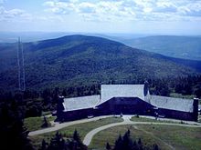
The memorial tower on the summit |
||
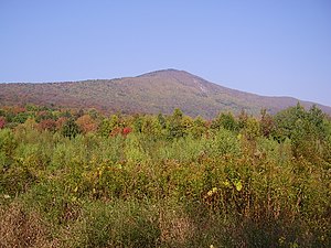
At 3,491 ft (1,064.1 m ), Mount Greylock is the highest natural elevation in the state of Massachusetts in the United States . Geologically it belongs to the Taconic Mountains in northwestern Massachusetts, but is usually associated with the Berkshire Mountains to the south . At the summit is a 28-meter-high lighthouse-like memorial tower built in 1931/32 for Massachusetts' war veterans since the First World War .
The mountain is best known for the view from the summit, from where five states can be seen in good weather. In addition, the only boreal coniferous forest in Massachusetts thrives on its slopes . The hiking trails around Mount Greylock also include a section of the Appalachian Trail . In 1898 the Mount Greylock State Reservation was established.
The 1,200 acres (4.9 km² ) Mount Greylock Summit Historic District at the top of the mountain was registered as a Historic District on the National Register of Historic Places on April 20, 1998 under number 98000349 .
geography
From a geographical point of view, Mount Greylock belongs to a mountain range extending over an area of more than 120 km² between the Hoosac Mountains , the Berkshire Mountains, the Green Mountains and the Taconic Mountains, which in turn are part of the Appalachian Mountains . The top of the mountain is in the Adams metropolitan area , while its foothills extend into the towns of Cheshire , Lanesborough , New Ashford , North Adams, and Williamstown . In addition to Mount Greylock, the mountain range includes other, smaller elevations such as Saddle Ball Mountain and Mount Fitch .
In the northwest, Mount Greylock drains into the Green River , which flows into New York Harbor via the Hoosic River and Hudson River . The south side is drained via the Town Brook , which flows into the Long Island Sound via the Housatonic River . The other areas of the mountain drain directly into the Hoosic River.
From the top of the mountain there is an all-round view in good weather with a visibility of up to 220 km, including areas of the states of Massachusetts, New York , Connecticut , Vermont and New Hampshire .
Geology and ecology
The as thrust resulting Mount Greylock consists as well as the Taconic Mountains predominantly of phyllite from the Ordovizium under which younger layers of metamorphic sedimentary rocks (mainly marble are located). The marble was quarried in Adams and North Adams quarries at the foot of the mountain.
During the Pleistocene around 18,000 years ago, the mountain and its surroundings were covered by the Laurentide Ice Sheet up to 1 km. The force of the ice shaped the mountain and landscape, leaving U-shaped valleys and boulders like Balance Rock in Lanesborough, now in Balance Rock State Park . The Kar The Hopper is the southernmost valley of its kind in all of New England and was designated a National Natural Landmark in 1998 because of the large primary forest of American red spruce trees there .
Mount Greylock is designated as an Important Bird Area . It serves as a habitat for birds that are otherwise not found in Massachusetts, such as the warbler and bicknell's thrush . The eBird database lists well over 100 different bird species that live in the immediate vicinity of the mountain.
history
Early history and naming

Before the arrival of European settlers lived in the area around Mount Greylock mainly Mahican - Indians . On the north side of the mountain passed with the Mohawk Trail, an important connection route between the Indian peoples who settled on the Hudson and Connecticut Rivers , which today forms part of Massachusetts Route 2 .
The mountain was first named Grand Hoosuc (k) and later Saddleback Mountain by the settlers in the 18th century . The origin of its current name, however, cannot be clearly established. The name Mount Greylock appears for the first time in 1819 and was already widespread around 1830. The name could go back to the gray clouds that often surround its summit, or to the gray haze in its higher elevations, or - what is considered the most likely variant - to the Sachem Gray Lock (1670–1750), leader of the Waranoak Indians. The chief was best known for his guerrilla warfare against the white settlers in Vermont and in western Massachusetts.
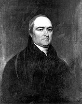
Among the first climbers on Mount Greylock were the then President of Yale University Timothy Dwight IV and the first President of Williams College Ebenezer Fitch , who climbed it in 1799 on a route that was probably laid out by the farmer Jeremiah Wilbur.
19th century
At Williams College, founded in 1793 in nearby Williamstown, the history of Mount Greylock was explored from the start. In May 1830, a group of students laid a path to the summit, now known as the Hopper Trail, which their college successors still climb annually on Mountain Day .
By the mid-19th century, the mountain was already very popular and attracted writers and artists such as Nathaniel Hawthorne , William Cullen Bryant , Oliver Wendell Holmes , Herman Melville and Henry David Thoreau , who took inspiration from its surroundings. The aforementioned processed their impressions in different ways. Hawthorne developed his story "The Unpardonable Sin" from this, while Melville is said to have reminded him of the snow-capped peak of an emerging white sperm whale , which he incorporated into Moby Dick . Thoreau wrote about his way to the summit on today's Bellows Pipe Trail in his book "A Week on the Concord and Merrimack Rivers".
Towards the end of the 19th century, the mountain had already been largely cleared to supply the surrounding industries. This practice led to wildfires and landslides , some of which were devastating , and after another outbreak of fire, a group of business people formed the Greylock Park Association (GPA) on July 20, 1885 . They then bought 400 acres (1.6 km² ) around the summit and began repairing access roads. To finance her work, she levied a toll of 25 US cents (around 6.85 US dollars today ) and an entrance fee of 10 US cents (around 2.86 US cents today) for the roads on the mountain . Dollars) for a lookout and observation tower built in 1889. In 1898 these beginnings resulted in the Mount Greylock State Reservation , which still exists today and covers an area of 12,455 acres (50.4 km²) .
20th century
In 1906, a Berkshire County commission began building the first road from the south to the summit. This was finally opened on September 16, 1907. Then she took care of the expansion of the hiking trails, so that in 1913 there were already 17 different routes.
In 1929 the Appalachian Trail was laid out in this region , but there were disputes between those involved over who was responsible. The path threatened to deteriorate again until its maintenance was finally taken over by the Mount Greylock Ski Club in 1937.
From 1931 to 1932, the Massachusetts (Veterans) War Memorial Tower was erected at the summit to commemorate the state's war veterans. The 107th Company of the Civilian Conservation Corps expanded the roads and paths on the mountain from 1933 to 1944 and also improved the health of the forest. The mountain became increasingly popular with skiers and winter tourists, so ski slopes were created. The Thunderbolt Trail was used for championships of the then United States Eastern Amateur Ski Association (now the United States Ski and Snowboard Association ) in 1938 and 1940 .
In October 1966, after long legal disputes, the management of the mountain was transferred from Berkshire County to the Massachusetts Department of Conservation and Recreation on the initiative of the Mount Greylock Protective Association, which was set up specifically for this purpose .
Buildings erected on the mountain
Veterans War Memorial Tower
The construction of the memorial tower - initially for veterans of the state in World War I , and later for all subsequent wars - was approved by the Massachusetts General Court in 1930 , which was also supported by then Governor Frank G. Allen , among others . The tower was originally intended to be built in the Boston metropolitan area, but it was decided to build it on Mount Greylock instead. It was completed in 1931 and 1932 at a total cost of $ 200,000 (this is approximately $ 3,350,000 today). The tower looks like a lighthouse and is permanently in operation in honor of the veterans; it can be seen at night from a distance of up to 70 mi (112.7 km) and for a long time had the brightest light source in the entire state of Massachusetts with 12 1500 watt lamps.
The 93 ft (28.3 m) high tower has eight observation posts, each framed by a frieze, and was not intended as a utilitarian structure at the time of planning , but was intended to convey classical austerity . Some details, such as the stone eagle at the foot of the tower, can be attributed to Art Deco . Although local residents and authorities voted to build the tower from locally mined material, it is made of granite stones extracted from a quarry near Quincy .
Bascom Lodge
The Bascom Lodge , built from 1932 to 1938 from slate extracted directly from Mount Greylock and from American red spruce growing there , was designed by an architect from Pittsfield . The Greylock Commission decided to build it after the previous structure fell victim to a fire in 1929. The refuge was named after John Bascom , who was a member of the commission and professor at Williams College.
Thunderbolt Ski Shelter
In 1940, the Thunderbolt Ski Shelter was built by the Civilian Conservation Corps as a place to warm up skiers hitting the Thunderbolt Trail . In February 2010, on the occasion of the 75th anniversary of this route, a ski race took place that commemorated the first run on February 17, 1935. Since then, the race has taken place annually, provided the conditions permit.
Radio towers
The mountain is also the location of three radio towers for radio and television signals. A fourth tower is owned by the National Oceanic and Atmospheric Administration (NOAA) but is out of order.
See also
Individual evidence
- ^ National Register Information System . In: National Register of Historic Places . National Park Service . Retrieved April 15, 2008.
- ↑ a b Chet Raymo, Maureen E. Raymo: Written in stone: a geological history of the northeastern United States . Globe Pequot Press, Old Saybrook, Conn. 1989, ISBN 978-0-87106-320-5 .
- ^ Balance Rock State Park. stateparks.com, accessed August 21, 2014 .
- ^ Henry W. Art: The Natural History of the Berkshires. Williams College , accessed August 21, 2014 .
- ↑ eBird. National Audubon Society , Cornell Lab of Ornithology , accessed August 21, 2014 .
- ↑ Mount Greylock. (No longer available online.) The BerkshireWeb, 1999, archived from the original January 4, 2015 ; accessed on August 22, 2014 (English). Info: The archive link was inserted automatically and has not yet been checked. Please check the original and archive link according to the instructions and then remove this notice.
- ^ Colin G. Calloway: The Western Abenakis of Vermont, 1600-1800 . war, migration, and the survival of an Indian people. University of Oklahoma Press, Norman 1990, ISBN 978-0-8061-2274-8 .
- ^ Timothy Dwight, Barbara Miller Solomon: Travels in New England and New York . Belknap Press of Harvard University Press, Cambridge, Mass. 1969, ISBN 978-0-674-90670-9 .
- ^ Mountain Day. Williams College, accessed August 22, 2014 .
- ↑ a b The Romantic Period. Massachusetts Department of Conservation and Recreation , accessed August 22, 2014 .
- ↑ Herman Melville's Arrowhead. (No longer available online.) Berkshire Historical Society, 2009, archived from the original January 11, 2000 ; accessed on August 22, 2014 (English). Info: The archive link was inserted automatically and has not yet been checked. Please check the original and archive link according to the instructions and then remove this notice.
- ^ Henry David Thoreau, Robert F. Sayre: A week on the Concord and Merrimack rivers . Viking Press, New York 1985, ISBN 978-0-940450-27-1 .
- ^ William H. Tague: The Rise and Evaporation of the Greylock Tramway Authority . In: Williams College (Ed.): Berkshire Review . tape III , no. 1 , 1967, ISSN 0005-920X .
- ↑ Acts and Resolves Passed by the General Court of Massachusetts 1966. (PDF) Chapter 444. The State Library of Massachusetts, accessed August 22, 2014 .
- ^ Acts and Resolves Passed by the General Court of Massachusetts 1933. (PDF) Chapter 336. The State Library of Massachusetts, accessed August 23, 2014 .
- ↑ Patricia Harris, David Lyon: You know you're in Massachusetts when ... 101 quintessential places, people, events, customs, lingo, and eats of the Bay State. Insiders' Guide, Guilford, Conn. 2006, ISBN 978-0-7627-4132-8 ( online in Google book search).
- ^ Bascom Lodge. Bascom Lodge, accessed August 23, 2014 .
- ^ A History of the Thunderbolt Ski Run. (No longer available online.) Thunderbolt Ski Runners, 2014, archived from the original on February 8, 2015 ; accessed on August 23, 2014 . Info: The archive link was inserted automatically and has not yet been checked. Please check the original and archive link according to the instructions and then remove this notice.
- ^ NWR Stations Listing for Massachusetts. National Oceanic and Atmospheric Administration, October 25, 2013, accessed August 23, 2014 .


