Long Island Sound
| Long Island Sound | |
|---|---|
|
Beach on Long Island Sound |
|
| Waters | North Atlantic ( Atlantic Ocean ) |
| Land mass | New York , Connecticut ( United States ) |
| Geographical location | 41 ° 6 ′ N , 72 ° 54 ′ W |
| width | Max. 34 km |
| length | 177 km |
| Coastline | 960 km |
| Greatest water depth | 91 m |
| Medium water depth | 24 m |
| Islands | NY / CT: Pelham Islands CT: Great Captain Island , Norwalk Islands , Kelsey Island , Thimble Islands , Falkner Island ; Plum Island , Great and Little Gull Island , Fishers Island (selection; from west to east) |
| Tributaries | NY: Nissequogue River (Long Island); Mamaroneck River, Blind Brook (both mainland) CT: |
|
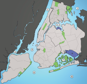
The largest waterways (light blue) of New York City (light gray / green / blue): |
|
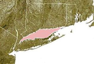
The Long Iceland Sound [ ˌlɑːŋ‿aɪ.lənd saʊnd ] is a tidal embossed inlet ( Engl. Tidal estuary ) of the Northwest Atlantic on the east coast of North America . Politically, the coastal water is part of the United States , with - roughly divided - its southern half belongs to the state of New York (mainly Long Island ) and its northern half to the state of Connecticut .
The most important cities directly on the Sound are (from west to east):
New York:
Connecticut:
Emergence
18,000 years ago the area of today's Sound was covered by the ice masses of the last Ice Age ( Wisconsin Glacial Episode ). The continental ice sheet scraped off an average of 20 meters of material from the land mass of what is now New England and deposited it again on the shelf. This material now forms the island of Long Island . The actual bay already existed before the glaciation, probably it was created by draining glacier water from older ice ages. The sediments at greater depths, however, show that the bay was also a freshwater lake in its history - separated from the sea.
Physical parameters
The sound is about 177 km long and up to 34 km wide. The average depth is 24 m, the maximum depth 91 m. The bay is open on both sides, with the larger opening to the Atlantic on the eastern side. At its western end, the sound merges into the narrow East River , which is the southwestern connection to the Atlantic. Numerous rivers such as the Connecticut River flow into the bay, most of them from the northern side. Due to the strong tidal current, which covers the entire bay, there is a strong mixing of the water body, the water in the eastern part is of Atlantic origin with a salt content of 35 per thousand, in front of the river mouths and in the west brackish water with a salt content of 22 per thousand is dominant. The largest bay on the north coast of Long Island is Smithtown Bay , there are also many smaller bays and fjords. Some islands are off the Connecticut coast and near the open side of the bay to the east.
traffic
The two banks of the Sound are connected by ferry traffic. The most important is the Bridgeport & Port Jefferson Ferry between Port Jefferson on Long Island and Bridgeport in Connecticut. This connection has existed since 1872. Various bridge building projects that have been discussed since 1930 have so far failed. There are also some submarine cables, including the 40-kilometer Cross Sound Cable , which connects the power grids of New England and Long Island.
Others
- In 1614 the first European , the Dutch Adriaen Block , reached the bay through the East River and crossed it completely.
- During the colonial era, the sound was also called The Devil's Belt . One reef in the bay was known as the Devil's Stepping Stones . There is the Stepping Stones Lighthouse .
- On June 15, 1904, more than 1,000 people died on board the excursion paddle steamer General Slocum on the way to the Locust Grove Recreation Park on Long Island Sound .
- The ashes of US pop singer Laura Branigan were scattered in the sound in 2004.
- The Sunken Meadow State Park is a state park on the bay, about 40 kilometers east of Manhattan on Long Iceland.
- Around four million people live in the cities around the Sound, and almost nine million in the entire catchment area.
Web links
Remarks
-
↑ see List of rivers of Connecticut (from: en-Wiki ; dt. 'List of rivers of Connecticut')
- According to that article, all of Connecticut's rivers drain into Long Island Sound; the list made there is therefore also complete for "our" article here - but too extensive to list all these flows here in the info box. Therefore only the reference directly to the above. English-language wiki article.
- ↑ Long Island, which is more of a small town, has no major city , hence the list from west to east and not clockwise.
Individual evidence
- ^ "Long Island Sound: An Atlas of Natural Resources", booklet "Prepared under the supervision of the Coastal Area Management Program" of the Connecticut Department of Environmental Protection, November 1977, "1. Glacial History "section, page 4
- ^ Long Island Sound Study: History of the Sound.
- ^ Long Island Sound Study: Long Island Sound - By the Numbers.
- ^ Long Island Crossings, Connecticut Roads.
- ^ Website of the operating company Cross-Sound Cable Company, LLC
- ^ History of the United States of America: from the discovery of the Continent, George Bancroft, 1886, Volume 1 p 489.
- ^ The Left Bank of the Bronx.
- ↑ Branigan's tomb
- ^ Long Island Sound Study: What makes it special


