Lower New York Bay
| Lower New York Bay | ||
|---|---|---|
|
Beach on the bay from Wolfe's Pond Park |
||
| Waters | Atlantic Ocean | |
| Land mass | Staten Island , Long Island | |
| Geographical location | 40 ° 31 ′ N , 74 ° 3 ′ W | |
|
|
||
| width | 32 km | |
| depth | 12 km | |
| Islands | Hoffman Island , Swinburne Island | |
| Tributaries | Hudson River | |
|
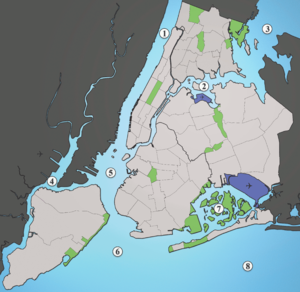
1: Hudson River , 2: East River , 3: Long Island Sound , 4: Newark Bay , 5: Upper New York Bay , 6: Lower New York Bay, 7: Jamaica Bay , 8: Atlantic |
||
The Lower New York Bay is a bay in front of the harbor of New York City . With the Upper New York Bay , it is through the strait The Narrows connected. It is the outer part of New York Bay and connects New York Harbor with the Atlantic .
location
The bay forms a triangle that is open to the Atlantic. On the western side is the island of Staten Island and New Jersey , the bay extends to the Sandy Hook peninsula . Brooklyn is on the east side and the bay extends to the tip of the Rockaway Peninsula . On the southern side, the bay is divided into Raritan Bay and Sandy Hook Bay . Due to its shape and location, Lower New York Bay offers hardly any protection for ships; protection is only granted behind The Narrows.
There are numerous parks and beaches along the bay. These include Brighton Beach and Coney Island in Brooklyn, the beaches of Sandy Hook , Breezy Point, and Jacob Riis Park , Wolfe's Pond Park , Great Kills Park, and Cheesequake State Park in Old Bridge .
In the bay there are two small artificial islands in the mouth of the Hudson River, in front of the South Beach district on Staten Island. Hoffman Island and Swinburne Island were built as quarantine islands to separate immigrants with infectious diseases who arrived on Ellis Island .
There are also numerous lighthouses in the bay and on the banks. On the New Jersey coastline, you'll find Chapel Hill Rear Range Light , Conover Beacon , Great Beds Light , Navesink Twin Lights, and Sandy Hook Light . On the New York coast are the Coney Island Light , New Dorp Lighthouse , Princes Bay Light and Staten Island Light, and in the bay are the Old Orchard Shoal Light and the West Bank Light .
Physical parameters
The bay is an estuary into which some large rivers such as the Hudson River and over the Newark Bay and the Kill Van Kull the Passaic River and the Hackensack River through the strait The Narrows and Arthur Krill drain. Due to the large opening to the Atlantic, the water has a relatively high exchange rate and a high salinity. The pollution from the rivers and the port is reflected in the high concentration of nutrients and the high level of germs in the water. The mean tidal range in the bay is around one meter.
history
The first European to sail into the bay was the Italian Giovanni da Verrazzano . He sailed into the bay on behalf of the French King Francis I in 1524 and anchored off Staten Island. The Verrazzano-Narrows Bridge over The Narrow was named after him. In the next few years more explorers came, but did not explore or describe the bay. It was only when Henry Hudson came to the bay in 1609 that he examined and described it and then sailed up the Hudson River. He published the first full description of the bay.
Individual evidence
- ^ Quarantine At New York in Harper's Weekly , September 6, 1879
- ↑ Water Body Inventory for the New York Harbor Watershed, New York State Department of Environmental Conservation (pdf)
- ^ NOAA - Tidal Station Locations and Ranges
- ↑ a b Rickie Lazzerini (2006) The History of New York, From early Native American cultures through WWII ( page no longer available , search in web archives ) Info: The link was automatically marked as defective. Please check the link according to the instructions and then remove this notice.


