Passaic River
| Passaic River | ||
|
River basins of Passaic River and Hackensack River |
||
| Data | ||
| Water code | US : 879159 | |
| location | New Jersey (USA) | |
| River system | Passaic River | |
| Drain over | Passaic River → Atlantic | |
| source | at Mendham, NJ 40 ° 45 ′ 41 ″ N , 74 ° 34 ′ 40 ″ W. |
|
| Source height | 165 m | |
| muzzle | in Newark Bay coordinates: 40 ° 42 ′ 44 " N , 74 ° 7 ′ 6" W 40 ° 42 ′ 44 " N , 74 ° 7 ′ 6" W. |
|
| Mouth height | 0 m | |
| Height difference | 165 m | |
| Bottom slope | 1.3 ‰ | |
| length | 129 km | |
| Catchment area | 2390 km² (6 km above the mouth) | |
| Discharge at the gauge Dundee Dam A Eo : 2085 km² Location: 27 km above the estuary |
MQ 2008/2015 Mq 2008/2015 HHQ (08/30/2011) |
38 m³ / s 18.2 l / (s km²) 733 m³ / s |
| Left tributaries | Rockaway River , Pompton River , Saddle River | |
| Right tributaries | Dead River | |
| Big cities | Newark , Paterson | |
| Medium-sized cities | Passaic | |
|
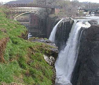
Great Falls of the Passaic River in Paterson, NJ |
||
The Passaic River [ pəˈseɪ.ɨk ] is a 129 km long river in the north of the US state New Jersey .
The upper reaches of the Passaic River makes many bends and meanders through the Great Swamp wetlands of the lowlands between the hills of urban and suburban northern New Jersey. Together with its tributaries, it drains the northern part of the state. The lower reaches largely runs through urbanized and industrialized areas of New Jersey. He also passes the center of Newark . The lower section of the Passaic River is severely polluted .
Tributaries
Tributaries of the Passaic River in the upstream direction are:
- First River (aka Mill Brook)
- Second River
- Third River or Yanticaw River
- McDonalds Brook
- Weasel Brook
- Saddle River
- Butcher Brook
- Lyncrest Brook
- Little Diamond Brook
- Diamond Brook
- Stevenson Brook
- Goffle Brook
- Molly Ann Brook
- Brook slippery skirt
- Peckman River
- Singac Brook
- Deepavaal Brook
- Pompton River
- Rockaway River
- Foulerton's Brook
- Spring Garden Brook
- Slough Brook
- Canoe Brook
- Cory's Brook
- Dead River
- Black Brook
- Great Brook
- Loantaka Brook
- Primrose Brook
- Penns Brook
- Indian Grove Brook
- Naak point Brook
- Salt Brook
Individual evidence
- ↑ USGS - GNIS - Passaic River
- ↑ USGS 01392600 Passaic R at Harrison NJ
- ↑ USGS 01389890 Passaic River at Dundee Dam at Clifton NJ
- ↑ PassaicRiver.com. "About the River."
Web links
- Lower Passaic River Restoration Project
- Passaic River Coalition
- Passaic River Boat Club
- Passaic River Institute, Montclair State University
- North Jersey District Water Supply Commission
- Delaware and Hudson Canoe and Kayak Club: Passaic River- Source to Mouth
- My Passaic River Kayak Trip - 90 Miles of Fun in Northern New Jersey - June 2000 - by Steve Garufi
- Great Swamp National Wildlife Refuge
- US Geological Survey: NJ stream gaging stations
- Passaic River Rowing Association


