
Robertshall mine
| Robertshall mine | |||
|---|---|---|---|
| General information about the mine | |||
 |
|||
| other names | Robertshall Union | ||
| Mining technology | Underground mining | ||
| Funding / year | 49,600 t | ||
| Funding / total | 84,400 t | ||
| Information about the mining company | |||
| Operating company | Gebr. Stern KG | ||
| Employees | approx. 210 | ||
| Start of operation | 1919 | ||
| End of operation | 1922 | ||
| Funded raw materials | |||
| Degradation of | Brown coal | ||
| Brown coal | |||
| Mightiness | 8-10 | ||
| Greatest depth | 17 m | ||
| Geographical location | |||
| Coordinates | 53 ° 27 '19 " N , 9 ° 53' 47.7" E | ||
|
|||
| Location | House break | ||
| local community | Hamburg | ||
| Independent city ( NUTS3 ) | Hamburg | ||
| country | Free and Hanseatic City of Hamburg | ||
| Country | Germany | ||

The mine Robert Hall (also mining company Robert Hall ) was a downhole brown coal - mine in the Harburg low mountain range , in today's Hamburg district Hausbruch . The mine was only in operation from 1919 to 1922, when, due to the scarcity of raw materials after the First World War, it was also economically worthwhile to mine unproductive deposits . The extracted lignite was delivered exclusively to the Vereinigte Gummiwaaren Fabriken Harburg - Vienna in Harburg .
geology
In the area of the mine there are three Miocene lignite seams , the upper seam with a thickness of up to 8.5 meters at a depth of about 17 meters, the middle seam at a depth of about 35 m with a depth of 4–10 meters and the lower seam at a depth of 100 to 300 Meters with a thickness of about four to eight meters. The groundwater level is in the range from 17 to 17.5 m above sea level. NN . The turf hanging bench of the conveyor shaft had a height of 31.5 m above sea level. NN . The seam consisted of a sand-coal mixture with grain sizes of the coal from wheat grain to child's head size, whereby the majority of the coal was in the size of plums.
Shaft position: 53 ° 27 ′ 22 ″ N, 9 ° 53 ′ 41 ″ E
history
During excavations for a well on the weekend property of the widow of the haulage contractor Paul, workers came across the upper seam. Ms. Paul unsuspected at the Mining Office together 423 Celle ha large mining concessions , which later Robert and Louis were called. After Hugo Strache had appraised the deposits , she sold her mining rights to the company Gebr. Stern KG from Dortmund in 1917 . After the Stern company had concluded a supply contract with the United Gummiwaaren Fabriken Harburg - Vienna, the newly founded Robertshall union began on December 6, 1919 with the mining of coal on two levels at 17 and 13 m depths. The mining operation was initially started with a simple wooden headframe; this with the intention of replacing the headframe with a conventional steel headframe after achieving economic operation and to erect a second headframe about 200 m away near the Hohlredder road. Usually two shafts were always required in mining for safety reasons, so that a second way out is possible in the event of an accident. However, due to the lack of economic efficiency, neither the second production shaft was built nor the first shaft was upgraded to a steel frame construction. The operation was organized by two Steiger from the Harz Mountains , the miners were recruited from the Upper Harz, and helpers and apprentices were recruited from Hamburg and Harburg. At that time, the Harz miners were offered a fixed wage for each cart, regardless of the content (sand or coal), which was completely unusual in the mining sector, whereas in the Harz they were usually paid on the basis of the yield. Under these favorable conditions, a number of miners were willing to work in Hausbruch. Worked in three shifts with 60 men under and about eight men over days .
As early as 1921, wastewater from the mine and coal washer caused protests by the Jork community , as the wells in Francop were so heavily polluted by the wastewater that it was no longer possible to draw drinking water. A sedimentation basin was built north of the shaft, but it never achieved the desired clarification effect.
Settlement basin location: 53 ° 27 ′ 26 ″ N, 9 ° 53 ′ 37 ″ E
After the upper coal seam on the 17 m level was exhausted, an attempt was made to penetrate the lower coal seam on the 35 m level through an inclined shaft , but this failed due to massive water ingress. After Hamburg's coal supply from the Ruhr area consolidated again at the beginning of the 1920s and the coal price fell again as a result, the mining of Harburg coal became increasingly unprofitable and mining operations ceased on September 22, 1922. The bay that the Ehestorfer Heuweg under crossing routes and the weather bays were with sand filled . The underground wooden expansion was partly, as well as large parts of the above-ground wooden houses dismantled and reused. The remaining wooden structures above ground fell into disrepair.
When the raw material situation deteriorated again after the Second World War in 1947, the possibilities of restarting the Robertshall mine were examined again. For this purpose, twelve test drillings were carried out in order to be able to estimate the stocks. A resumption of the promotion was planned for 1947; the approval of the mining authority was already available. The resumption of mining operations was, however, rejected for economic reasons.
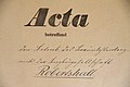
Cover of a file in the Clausthal mountain archive

Articles of association of the health insurance company of the Robertshall mining company


present
At present, some day breaks, pinging , remains of walls and foundations of the coal washing plant and the street name Beim Bergwerk point to the former Robertshall mine. The stone canteen on the same street has served as a residential building since the mine was closed. The former coal handling point is now a bus turning loop on Stader Straße . A model of the mine was shown for many years in the permanent city history exhibition of the Helms Museum (today the Hamburg Archaeological Museum ).
Location of the former coal washing plant: 53 ° 27 ′ 23 ″ N, 9 ° 53 ′ 40 ″ E.
Location of the former canteen: 53 ° 27 ′ 21 ″ N, 9 ° 53 ′ 38 ″ E
In the years 2000 and 2001, the underground situation was superficially compared by comparing the crack system with the existing fractures and various stretches of up to 100 m in length were identified, which until then seemed to be self-supporting in the lignite. Students from the Helms Museum took part in this study, led by Rolf Czapiewski. In 2000, with the support of students and employees of the Helms Museum and the Celler Brunnenbau company, Czapiewski carried out boreholes with well drilling rigs in this area. A total of about 15 holes were drilled at different points, of which only the last hole hit an old section at a depth of about 15 meters that had not yet been broken. This area was partially bricked up and originally backfilled, but the backfill has either collapsed or washed out over the decades, so that voids between the roof and the ground at a height of approx. 40–50 cm could be detected. The backfilling was partly done with lignite. At that time, smaller pieces of brown coal could be recovered. The length of the route could not be estimated, as the photographic technology of the time could only illuminate short stretches with a flash. The idea of making this route passable again for exploratory purposes with the help of frost stabilization failed during the planning phase, as the Forest Office refused permits for excavations or large-scale drilling in the forest area. Since then, further underground exploration work has been suspended.
The Bergwerk Robertshall eV association was founded in 2015 in order to process and document the history of the mine. In the summer of 2018, a memorial with an information board and a mining memorial path were erected on the former site.
In December 2017, the Bergwerk Robertshall eV association carried out ground penetration radar measurements at some points and found that there were still existing ground irritations in the area of the Ehestorfer Heuweg road and in the forest. At these points, cavities in tunnels and so-called soft spots through uncompacted material such as lignite have been identified. Since road construction work was pending, this information was forwarded to the responsible office of the Hamburg building administration, but ignored there. Road construction began in May 2019. In August, the places previously named by the association actually began to sag, which significantly impeded and delayed the construction work. After excavations, considerable amounts of brown coal were found there, which are not stable and have to be completely excavated in the street area.

Inscription on the remains of the foundations of the former coal washing plant in 2011

Remnants of the coal washing foundation in September 2011
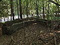
Remains of the coal washing machine seen from above 2011


advancement
The brown coal was only in Oberflöz on the 17-m- sole degraded. The process must have been a kind of site construction in which stretches were driven, the roofs of which were gradually broken up to a height of four meters. The routes were expanded with wooden door frames . In order to reach the lignite lying above, the 13 m level was laid in March 1921. The mined lignite was cut to the 17 m level below and transported to the shaft by truck . The tunneling of the sections was carried out with good luck, as the course of the seam was not known due to a lack of prospecting . The expansion was largely removed from the charred buildings , which led to the breakage . From other sources it is known that the stamps remained in the mine workings in the last months of mining . The ventilation took place through weather shafts, which were dug to the surface as required. In the case of water ingress, there was only surface water that seeped in, which was channeled to the shaft and pumped out from there. For a short time there was a deeper bed (34 m), which was soon abandoned due to the inflowing water.
transport
First of all, the extracted coal was transported directly to the rubber goods factory by truck and washed out of the sand on the factory premises. Later a coal washing machine with two sieve drums was built next to the shaft, in which the coal was washed out with the pumped pit water . The pure coal was then transported on a single-track field railway along the Ehestorfer Heuweg with a diesel locomotive to an above-ground bunker at the Jägerhof . In 1921 a three-kilometer-long material cable car was built to transport the coal from the bunker to the transhipment station in Bostelbek, where the coal was loaded onto trucks and transported to the rubber goods factory.
Cable car top station: 53 ° 27 '25 "N, 9 ° 53' 39" E
Cable car bottom station: 53 ° 28 '14 "N, 9 ° 55' 53"
E Rubber goods factory: 53 ° 27 '15 "N, 9 ° 59 ′ 21 ″ E
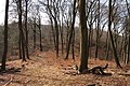
The aisle of the cable car route still visible in 2018
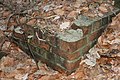
Remnants of the foundations of the cable car structures
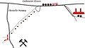
Schematic sketch of the coal transport from Hausbruch to Harburg in 1922


literature
- Hinrich Prigge: The “Robertshall” lignite mine near Hamburg-Hausbruch . In: Museum and Heimatverein Harburg Stadt und Land eV (Hrsg.): Harburger Jahrbuch . No. 6 , 1956, ISSN 0722-6055 , p. 39-49 .
- Rolf Czapiewski: The Robertshall lignite mine in Hausbruch (= the flange wheel . No. 3 ). Flanged wheel, Stade 2001, p. 3-13 .
Web links
- Robertshall mine.
- Michael Grube: A brown coal mine near Hamburg - Robertshall. In: geschichtsspuren.de.
- Authority for Urban Development and the Environment, Hamburg: Robershall mine. Archived from the original on August 1, 2012 .
- Thomas Hirschbiegel: When Hamburg had a mine: Harburg's coal miners. In: Hamburger Morgenpost . March 13, 2017 .
- Anke Settekorn: The mine that hardly anyone knows about. In: Kreiszeitung-Wochenblatt. 3rd August 2018 .
Individual evidence
- ^ Hinrich Prigge: The lignite mine "Robertshall" near Hamburg-Hausbruch . In: Museum and Heimatverein Harburg Stadt und Land eV (Hrsg.): Harburger Jahrbuch . No. 6 , 1956, ISSN 0722-6055 , p. 39–49 ( PDF in the Hamburg State and University Library ).
- ↑ a b c d e Jörn Claußnitzer: Model of the “Robertshall” lignite mine . In: Ralf Busch (ed.): Hidden treasures in the collections . Wachholtz, Neumünster 1998, ISBN 3-529-02001-X , p. 218-219 .
- ↑ a b c d Michael Grube: A brown coal mine near Hamburg. Robertshall. In: geschichtsspuren.de. Retrieved March 7, 2015 .
- ^ Robertshall mine - start. Retrieved April 26, 2019 .
- ↑ Lars Hansen: Complete closure of Ehestorfer Heuweg: residents are angry. August 20, 2019, accessed on August 25, 2019 (German).