Prospecting (geology)
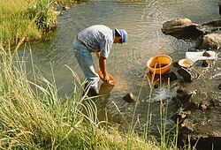
In mining and geology , prospecting is the search for and exploration of new, previously unknown raw material deposits using geological, geophysical, geochemical and mining methods. The previously common term prospecting is rarely used today.
Deposits close to the surface have often been discovered by chance throughout history. Today, the systematic search for new deposits usually begins with a thorough study of the literature and maps in specialist libraries, at the geological services ( state offices ) of the respective countries and (if possible) with mining companies that are already active in the region. Since the cost of an extensive exploration program is very high, the work must be carried out in different phases, each ending with a clear decision by the geologist as to whether it is worthwhile to continue the work or to abandon it.
Basics
The first phase of the search consists of reconnaissance in the area. This is followed by the actual prospecting, the prospecting. The general geological nature of the region is somewhat known at this point; However, deposits are still unknown.
In this situation, an obvious approach is to look first in areas in which deposits of the desired raw materials are already known, hence the saying “elephants can be found in elephant land” among prospectors. On the other hand, it also has its advantages to search in undeveloped regions for which little geological data is available. The risk of total failure must be weighed against the chances of an unexpected, large find.
Aerial photographs , satellite images and geophysical explorations with the help of airplanes or helicopters, so-called airborne methods, provide an important basis for the first overview mappings. However, this data alone is worthless without a review of the geological conditions in the area, such as the investigation and geochemical sampling of rocks , rubble and river sediments. In addition, there is the observation of soil discolouration, abnormalities in the shape of the terrain and vegetation .
Find and findings
If the signs suggest a deposit, special mapping is carried out, the surface is digged , or the first shallow exploratory drilling is carried out. In this phase methods of soil geophysics are also applied, such as gravimetry , seismics , magnetics , electrical and radar methods .
A period of about three years is expected for prospecting a deposit. At the end of this phase, there should be at least one prospective (i.e., good ore good) area known to warrant further investigation. In the best case scenario, the completed prospecting phase is followed by exploration of the deposit found.
Prospecting on the sea floor
According to Section 4 of the Seabed Mining Act (MbergG), anyone wishing to carry out prospecting in an area beyond the scope of national sovereignty on the seabed or in the seabed must have been registered by the Secretary General of the International Seabed Authority.
See also
literature
- FW Prokop, W. Streck, M. Sagher, RW Tschoepke, HW Walther, H. Pietzner, G. Stadler, H. Vogler, H. Werner: Investigation and evaluation of deposits of ores, usable minerals and rocks (Vademecum 1) . 2nd Edition. Geological State Office of North Rhine-Westphalia, Krefeld 1981.
- Literary
- Jocelyne Saucier : Never without her . Translated by Sonja Finck , Frank Weigang. Insel, Berlin 2019 (Roman, ore exploration in Canada ).
