
Roshe
| coat of arms | Germany map | |
|---|---|---|

|
Coordinates: 52 ° 59 ′ N , 10 ° 45 ′ E |
|
| Basic data | ||
| State : | Lower Saxony | |
| County : | Uelzen | |
| Joint municipality : | Roshe | |
| Height : | 53 m above sea level NHN | |
| Area : | 71.91 km 2 | |
| Residents: | 2598 | |
| Postal code : | 29571 | |
| Primaries : | 05803, 05863 | |
| License plate : | UE | |
| Community key : | 03 3 60 018 | |
| LOCODE : | DE ZFF | |
| Community structure: | 17 districts | |
| Association administration address: | Lüchower Str. 15 29571 Rosche |
|
| Mayor : | Michael Widdecke ( CDU ) | |
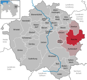
| Location of the municipality of Rosche in the district of Uelzen | ||
  |
||


Rosche is a municipality in the district of Uelzen , Lower Saxony . The municipality of Rosche is the administrative seat of the joint municipality of Rosche .
geography
Geographical location
In terms of nature, the area around the community is to be assigned to the Uelzen basin, it is located in the east of the Lüneburg Heath . The surrounding area used to be a heather, swamp and wetland area in the course of the Wipperau stream .
Community structure
The municipality of Rosche consists of the districts Borg , Gauel , Göddenstedt , Gut Göddenstedt , Hohenweddrien , Katzien , Nateln , Neumühle , Polau , Probien , Retzien , Rosche-Prielip , Schwemlitz , Schmölau , Stütensen , Teyendorf and Zarenthien as well as the Göddenstedter mill .
history
In the area of Rosche-Prielip, the enclosed round building in the former town of Prielip shows that Slavs lived there around 2400 years ago.
In 1130 Roshe was first mentioned in a document.
In the late Middle Ages, however, Rosche belonged to the Duchy of Braunschweig-Lüneburg, near the then very prosperous city of Uelzen, which was well known in the whole area because of the Uhlenköper history and did a lot of trade, the main reason why Uelzen was so wealthy at the time. So Rosche also became wealthy through the trade with Uelzen, Rosche mainly traded in potatoes and bread baked from flour, the trade collapsed with the great fire of Uelzen. At the turn of the century, in the modern era, the Duchy of Braunschweig-Lüneburg became the Kingdom of Hanover, at that time Uelzen had already been rebuilt after the great fire, so the trade could also be rebuilt.
At the beginning of the German Empire, with the ever-increasing expansion of Prussia, the Kingdom of Hanover also swallowed up. At this time the sugar factory in Uelzen was also built, this also influenced the trade with Uelzen, because for sugar you need sugar cane, or sugar beet, since you cannot grow sugar cane in Germany, many farms were growing sugar beets at that time, including many farms in Rosche and the surrounding area so not only the merchants with the trade in Uelzen became rich, but also the farmers who were still poor up until then. With the money from the sugar beet, the farmers were able to build large, beautiful, valuable farms, the beet castles, not only in Rosche and the surrounding area, but also in the entire late Uelzen district.
Incorporations
On July 1, 1972, the communities Borg, Göddenstedt, Hohenweddrien, Katzien, Nateln, Polau, Schmölau, Schwemlitz, Stütensen, Teyendorf and Zarenthien were incorporated.
politics
Municipal council
The council of the municipality of Roshe consists of 13 councilors.
| CDU | SPD | Green | total | |
| 2016 | 8 (60.6%) | 3 (25.7%) | 2 (13.7%) | 13 seats |
Last local election on September 11, 2016
Mayor / Administration
Michael Widdecke (CDU) is the honorary mayor. The municipal council has appointed the general representative of the mayor of the entire municipality, Rolf Musik, as the municipality director. The administrative business of the community is done in the Samtgemeinderathaus.
coat of arms
The coat of arms of the municipality of Roshe is split in red and gold. On the left is a twelve-pinnate silver ash leaf. On the right a blue brook, accompanied by a blue millstone above and a blue ploughshare below.
Buildings
The St. Johannis Church is a neo-Gothic brick hall that was built around 1800 according to plans by the architect Ernst Wilhelm Wagner and inaugurated in 1862.
Sports
Sports club of the place is the "SV Rosche", in which several sports are offered. The first men's soccer team played in the Lower Saxony state league at the end of the 1990s.
Sons and daughters of the church
- Uwe Becker (born December 10, 1955), athlete, runner-up European champion
Trivia
Rosche was implemented as the card of the same name for the computer game ARMA 3 . The map shows the community and its surroundings in great detail with a total area of 236 km² and can be incorporated into the game as a modification and combined with any other modifications. The tasks of the player can therefore vary from a military mission to an everyday simulation.
Individual evidence
- ^ Federal Statistical Office (ed.): Historical municipality directory for the Federal Republic of Germany. Name, border and key number changes in municipalities, counties and administrative districts from May 27, 1970 to December 31, 1982 . W. Kohlhammer GmbH, Stuttgart / Mainz 1983, ISBN 3-17-003263-1 , p. 238 .
- ↑ Preliminary final result
- ^ Steam Workshop :: Rosche, Germany. Retrieved October 23, 2018 .
Web links
Altenmedingen | Bad Bevensen | Bad Bodenteich | Barum | Beehive | Ebstorf | Eimke | Emmendorf | Gerdau | Hanstedt | Himberg Mountains | Jelmstorf | Lüder | Natendorf | Oetzen | Rätzlingen | Römstedt | Roshe | Schwienau | Soltendieck | Stoetze | Suderburg | Suhlendorf | Uelzen | Vest | Wrestedt | Wriedel
Borg | Gauel | Göddenstedt | Göddenstedter Mill | Gut Göddenstedt | Hohenweddrien | Catsia | Nateln | Neumühle | Polau | Probien | Retzia | Rosche-Prielip | Schwemlitz | Schmölau | Stütensen | Teyendorf | Tsarists