Upper New York Bay
| Upper New York Bay | ||
|---|---|---|
|
Ships in Upper New York Bay |
||
| Waters | Atlantic Ocean | |
| Land mass | Long Island , Manhattan , New Jersey | |
| Geographical location | 40 ° 40 ′ 6 ″ N , 74 ° 2 ′ 44 ″ W | |
|
|
||
| width | 6 km | |
| depth | 9.5 km | |
| Islands | Governors Island , Liberty Island , Ellis Island | |
| Tributaries | Hudson River , East River , Kill Van Kull | |
|
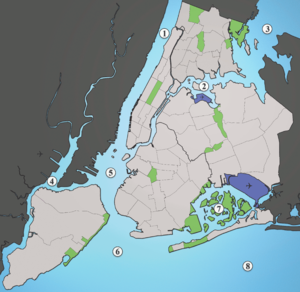
1: Hudson River, 2: East River, 3: Long Island Sound, 4: Newark Bay, 5: Upper New York Bay, 6: Lower New York Bay, 7: Jamaica Bay, 8: Atlantic Ocean |
||
The Upper New York Bay is a bay south of Manhattan in the US states New York and New Jersey . It is the northern part of New York Bay , which also consists of Lower New York Bay and The Narrows canal , which connects the two bays. Upper New York Bay forms the central part of New York Harbor .
location
The bay is bounded by the southern tip of Manhattan to the north, the New York borough of Brooklyn to the east, Staten Island and The Narrows Canal to the south, and Bayonne and Jersey City in New Jersey to the west. The Narrows strait connects Upper New York Bay with Lower New York Bay and finally the Atlantic . With a strong tidal current, this strait ensures a high exchange of water with the Atlantic, but it also represents a natural protection for the bay. The Hudson River and the East River , which forms the connection to Long Island Sound , end in the bay. About the Kill Van Kull south of Bayonne, the bay is connected to Newark Bay, which is also influenced by the tides. The tidal current transports around 100,000 tons of suspended matter from Upper New York Bay to Newark Bay each year, where they sediment. The Passaic River and the Hackensack River flow into Newark Bay and finally drain through the Kill Van Kull into Upper New York Bay.
There are numerous islands in the bay, the largest being Governors Island , Liberty Island and Ellis Island as well as the large underwater reef Robbins Reef , on the New Jersey side. The reef is marked by the Robbins Reef Lighthouse on a small island. The reef used to be one of the largest oyster beds in the world. With the increase in water pollution at the end of the 19th century, the oysters disappeared from the bay.
Furthermore, in the bay on the Brooklyn side is Gowanus Bay , into which the Gowanus Canal flows, and a small bay in front of Red Hook , the Buttermilk Channel , the waterway between Brooklyn and Governors Island and the Bay Ridge Channel on the eastern side of the Bay in front of the Narrow. On the west side are the Greenville Channel and the Claremont Terminal Channel .
Physical parameters
The bay's water consists of fresh water from the Hudson River and salt water that comes from the tidal currents mainly through the Narrows Channel and the East River. These water masses mix in the bay. The mean exchange time of the water in the bay is about two weeks, the contribution of the Hudson River to this is negligible. If the water were only exchanged through the Hudson River, the mean exchange time would be about 5 months. The water in the bay therefore consists mainly of salt water of marine origin with brackish water near the mouth of the Hudson River.
Trivia
The Staten Island Ferry crosses the bay on its approximately half-hour journey between Whitehall Street in Manhattan and the St. George Ferry Terminal on Staten Island.
The Owls Head sewage treatment plant in Bay Ridge , a borough of Brooklyn, feeds the treated wastewater from around 750,000 people into the bay.
The Brooklyn-Battery Tunnel , the road link between Manhattan and Brooklyn, runs below the bay.
Large parts of New York are about 3 meters above sea level . In order to protect these areas from a flood of the century , studies were carried out that show that it is possible to close Upper New York Bay and the waterways connected to it with three weirs and thus protect the urban area, similar to the Thames Barrier in London is already being done.
Individual evidence
- ↑ Joel A. Pecchioli et al: The New Jersey Toxics Reduction Workplan for New York - New Jersey Harbor: Study IE - Hydrodynamic Studies in the Newark Bay Complex. Division of Science, Research and Technology Research Project Summary, New Jersey Department of Environmental Protection, 2006. (pdf)
- ↑ Mark Kurlansky: The Big Oyster. Random House Trade paperbacks, New York 2006, ISBN 0-345-47639-5 .
- ↑ OCEANOGRAPHIC FEATURES AND PROPERTIES, National Sea Grant Library University of Rhode Island (pdf)
- ↑ New York City's Wastewater Treatment System, New York City Department of Environmental Protection (pdf)
- ↑ Malcolm J. Bowman et al .: Hydrologic Feasibility of Storm Surge Barriers to Protect the Metropolitan New York - New Jersey Region Full Report, Marine Sciences Research Center, Stony Brook University 2005. (pdf; 9.7 MB) ( page no longer available , Search in web archives ) Info: The link was automatically marked as defective. Please check the link according to the instructions and then remove this notice.


