
Staten Island
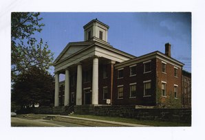 former Staten Island Courthouse |
|
| administration | |
|---|---|
| US state : | new York |
| Administrative headquarters : | |
| Foundation : | 1683 |
| Demographics | |
| Residents : | 495,747 (2020) |
| Population density : | 3,272.3 inhabitants / km 2 |
| geography | |
| Total area : | 265.5 km² |
| Water surface : | 114.0 km² |
| map | |
 |
|
| Website : www.statenislandusa.com | |
Staten Island [ ˌstætənˈaɪlənd ] is an island on the east coast of the United States of America . The island on the one hand is one of the five boroughs ( boroughs ) of New York City and on the other hand, the Richmond County of the State of New York , along with several small uninhabited surrounding islands: collision Iceland (West), Isle of Meadowns (southwest), Shooters Iceland (North , for the most part), as well as the man-made islands Hoffman Island and Swinburne Island to the east.
geography
Staten Island (Richmond) is located southwest of Manhattan and west of the borough of Brooklyn on Long Island . To the north is Upper New York Bay and to the east is The Narrows Canal , which separates the island from Long Island and Lower New York Bay . The island is connected to Brooklyn via the Verrazzano-Narrows Bridge, which is subject to a toll (in the direction of Staten Island) . The free Staten Island Ferry for pedestrians runs between Staten Island and Manhattan . To the west and north, the island is separated from the state of New Jersey by the narrow Arthur Kill and the Kill Van Kull . The name Kill is derived from the Dutch word for a canal, which there are several variants in the region. The Goethals Bridge , the Bayonne Bridge and the Outerbridge Crossing , which are subject to tolls (in the direction of Staten Island) lead to New Jersey .
The highest point on the island, Todt Hill (125 m), is also the highest point in New York City.
story
Finds of the Clovis culture have been made on Staten Island, suggesting a 14,000 year old settlement. In 1520, Giovanni da Verrazzano's expedition members were the first Europeans to discover Staten Island. From 1624 to 1667 the island belonged to the Dutch colony Nieuw Nederland and was called States Eylandt . During this time there was a war between the Dutch settlers and the indigenous people, the so-called pig war . In 1667 the Netherlands ceded Staten Island to the English in the Treaty of Breda , the island became part of New England until the USA declared its independence in 1776 . In 1788 the island was divided into four cities: Castleton (northeast), Northfield (northwest), Southfield (east) and Westfield (southwest). In 1860, Middleton became a fifth town from parts of Castleton and Southfield. All five cities were dissolved when Staten Island became a municipality of New York in 1898. On November 21, 1964, the Verrazzano-Narrows Bridge was opened, which connects the island with Brooklyn, which led to a sharp increase in population in the following decades. Staten Island was hit hard by Hurricane Sandy in 2012 ; 24 people died.
cards
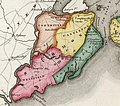
The four original cities of Staten Island (1839 map)

Map of Staten Island (1891), with five cities

Community Districts (with Staten Island in the southwest)
_cropped_from_Richmond_Queens_Kings_counties_map_by_David_Burr_1839.jpg)


Attractions

In addition to some remarkable houses from the 17th and 18th centuries, Staten Island includes the Conference House from 1680 and Voorlezer's House from 1695, the two oldest surviving school buildings in the USA.
Historic Richmond Town is a historic city and museum complex in the Richmondtown neighborhood. The site includes over 30 historic buildings dating from the late 17th century to the early 20th century. The museum shows the colonial American style.
There are many parks such as the Staten Island Greenbelt in the central part of the island and Wolfe's Pond Park , Great Kills Park and Conference House Park on the south coast. The Postcards memorial stands on St. George Esplanade to commemorate the residents of Staten Island among the victims of the September 11, 2001 terrorist attacks .
The Staten Island Ferry runs between Staten Island and Manhattan past the Statue of Liberty .
The Alice Austen House exhibits photographs by Alice Austen (1866–1952).
Six locations have National Historic Landmark status . 51 buildings and sites in the county are registered in the National Register of Historic Places (as of February 20, 2018).
Museums
- Garibaldi-Meucci Museum
- Historic Richmond Town
- Jacques Marchais Museum of Tibetan Art
- Staten Island Museum
etymology
The name comes from the Dutch state Eylandt ("estate island"), after the states Generaal (" States General "), the parliament of the Netherlands at that time . The island belonged to the former colony of New Amsterdam in Nieuw Nederland or Nova Belgica .
Population, economy and education


With a population of around 440,000, Staten Island is the least populous district of New York. The cityscape with its suburban character is characterized by loosely built-up residential areas and green spaces.
There are major shipyards and oil refineries on the island , as well as various colleges and a campus of Saint John's University .
traffic
The Staten Island Ferry connects the St. George Terminal on Staten Island with the Whitehall Terminal in Lower Manhattan . The NYC Ferry plans from 2021 with the St. George route (SG) is a ferry service between St. George Terminal and the west side of Manhattan with ferry docks in Battery Park City and Midtown West .
In the New York metropolitan area, Staten Island is accessible on Interstate 278 from Brooklyn via the Verrazano-Narrows Bridge . There are other road connections to New Jersey . Here you can go over the Bayonne Bridge to Bayonne , over the Goethals Bridge to Elizabeth (Interstate 278) and over the Outerbridge Crossing Bridge to Perth Amboy (NY 440).
The Staten Island Railway runs along the east coast of the island . The Midland Beach Railway Company operated a miniature railway in Midland Beach around 1903 .
landfill
Since 1948, located on Staten Iceland, the Fresh Kills - landfill , which served the city of New York for more than half a century as a central dump. The landfill was one of the largest man surveys the world and was for their strong outgassing of methane gas notorious. In March 2001 it was closed after increasing protests; Renaturation began in 2003 . The rubble from the World Trade Center , which was destroyed by terrorist attacks, was stored here from 2001/2002.
Administrative division
Staten Island is divided into three so-called "Community Boards", which in turn are divided into 64 Neighborhoods :
| Staten Island CD 1 | Staten Island CD 2 | Staten Island CD 3 |
|---|---|---|
|
|
|
Not yet assigned:
- Brighton Heights
- Caliville
- Heartland Village
- Lighthouse Hill
- Manor Heights
- Richmondtown
- Rudolph Lake
- Tottenville Beach
- Ward Hill
- Willowbrook
Culture
literature
- Michael Rosenfeld, Charles LaCerra (Eds.): Community, Continuity and Change: New Perspectives on Staten Island History. Pace University Press, New York 1999, ISBN 978-0-944473-46-7 .
Web links
Individual evidence
- ↑ dapd / Reuters / mak: "Sandy" damage: Too little help - the people's soul is cooking in Staten Island. In: welt.de . November 2, 2012, accessed October 7, 2018 .
- ↑ nytimes.com: On Staten Island, Haunting Memories of Those Killed by Hurricane Sandy
- ↑ Map of Historic Richmond Town
- ↑ The Staten Island Ferry
- ↑ Sightseeing on Staten Island. Retrieved August 31, 2017 .
- ↑ aliceausten.org
- ↑ Listing of National Historic Landmarks by State: New York . National Park Service , accessed February 20, 2018.
- ↑ Search mask database in the National Register Information System. National Park Service , accessed February 20, 2018.
- ↑ see also : Garibaldi-Meucci Museum
List of counties in New York
Albany |
Allegany |
Bronx |
Broome |
Cattaraugus |
Cayuga |
Chautauqua |
Chemung |
Chenango |
Clinton |
Columbia |
Cortland |
Delaware |
Dutchess |
Erie |
Essex |
Franklin |
Fulton |
Genesee |
Greene |
Hamilton |
Herkimer |
Jefferson |
Kings (Brooklyn) |
Lewis |
Livingston |
Madison |
Monroe |
Montgomery |
Nassau |
New York (Manhattan) |
Niagara |
Oneida |
Onondaga |
Ontario |
Orange |
Orleans |
Oswego |
Otsego |
Putnam |
Queens |
Rensselaer |
Richmond, Staten Island |
Rockland |
Saratoga |
Schenectady |
Schoharie |
Schuyler |
Seneca |
St. Lawrence |
Steuben |
Suffolk |
Sullivan |
Tioga |
Tompkins |
Ulster |
Warren |
Washington |
Wayne |
Westchester |
Wyoming |
Yates
Coordinates: 40 ° 34 ′ N , 74 ° 9 ′ W