Westchester County
 Westchester County Courthouse |
|
| administration | |
|---|---|
| US state : | new York |
| Administrative headquarters : | White Plains |
| Foundation : | November 1, 1683 |
| Made up from: | Province of New York |
| Area code : | 001 914 |
| Demographics | |
| Residents : | 923,459 (2000) |
| Population density : | 823.8 inhabitants / km 2 |
| geography | |
| Total area : | 1295 km² |
| Water surface : | 174 km² |
| map | |
| Website : www.westchestergov.com | |
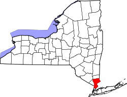
Westchester County is a county in southeast New York state in the United States . The county seat is White Plains .
history
Historical sights

- The historic Elephant Hotel in Somers is a landmark. It was listed as a Historic Monument in 2005 and is located on New York State Route 202 at number 335.
- In Port Chester is located in the North Main Street 's historic Lifesavers Building . The building of the candy manufacturer Life Savers of the same name was added to the National Register of Historic Places on July 11, 1985 as a historic site with the number 85001496 .
- The Yorktown Heights Railroad Station is in the town of the same name on Commerce Street . The railway station, built in 1877, was added to the NRHP in 1981 and is now a museum.
- Numerous personalities from sports, politics and culture are buried in the Gate of Heaven Cemetery in Hawthorne .
The county has a National Historic Site , Saint Paul's Church National Historic Site . 19 places have the status of a National Historic Landmark . 225 buildings and sites in the county are listed in the National Register of Historic Places (as of February 17, 2018).
geography
Westchester County is located between the Hudson River in the west and Connecticut in the south of the US state of New York . In the south of the county, in the area of the city of Yonkers , a peninsula is formed by the Long Island Sound in the southeast and the Hudson River in the west, which continues to the south. The county is bounded to the south by New York City .
| Putnam County | ||
|
Rockland County Hudson River |
|
Connecticut |
| Bronx County | Long Island Sound |
Long Island Sound's coastline is flat; there are sandy beaches and marshes. There are various islands in front of the coast:
Westchester County has been hit by tornadoes several times in the past, such as the Westchester County Tornado 1900 and the Westchester County Tornado 2006 .
geology
Just like in Manhattan, the county's subsoil consists of gneiss and mica slate .
traffic
To the north of the county, Interstate 684 runs through the countryside. It ends near Harrison on Interstate 287 , an east-west link between Interstate 87 and Interstate 95 . Both highways run north-south, the first along the Hudson River, the second along the Long Island Sound, from Connecticut to New York.
US Highway 9 always runs along the Hudson River and US Highway 1 along Long Island Sound . In the far north of the county, US Highways 6 and 202 also run in an east-west direction.
cities and communes
(in brackets population figures according to the United States Census 2000 )
|
Combined Towns / Villages
|
|
Individual evidence
- ↑ GNIS-ID: 974157. Retrieved on February 22, 2011 (English).
- ↑ NRIS
- ↑ Listing of National Historic Landmarks by State: New York . National Park Service , accessed February 17, 2018.
- ↑ Search mask database in the National Register Information System. National Park Service , accessed February 17, 2018.
Web links
- Official Website of Westchester County (English)
Coordinates: 41 ° 7 ′ N , 73 ° 48 ′ W


