Warren County (New York)
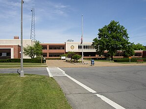
 Warren County Municipal Center |
|
| administration | |
|---|---|
| US state : | new York |
| Administrative headquarters : | Lake George |
| Foundation : | March 12, 1813 |
| Made up from: | Washington County |
| Demographics | |
| Residents : | 65,707 (2010) |
| Population density : | 29.3 inhabitants / km 2 |
| geography | |
| Total area : | 2,412.8 km² |
| Water surface : | 167.4 km² |
| map | |
| Website : www.co.warren.ny.us | |
Warren County is a county in the state of New York in the United States . At the 2010 census , the county had 65,707 residents and a population density of 29.3 people per square kilometer. The county seat is Lake George .
geography
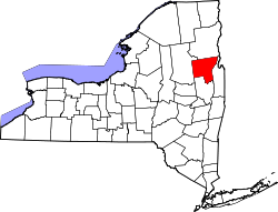
Warren County is located in northeast New York State, south of Lake Champlain . It consists of heavily forested hill country, the northeastern foothills of the Adirondack Mountains , and has many elongated lakes. The most important of these are Lake George and Lake Pleasant . The Hudson River , whose source is a few kilometers to the north, crosses the county from north to south-east. It is also the largest river in the county. Warren County covers an area of 2,412.8 square kilometers, of which 167.4 square kilometers are water.
Surrounding areas
| Hamilton County | Essex County | Essex County |
| Hamilton County |

|
Washington County |
| Hamilton County | Saratoga County | Washington County |
history
The county was named after Joseph Warren (1741–1775), a Massachusetts militia general who died in the Battle of Bunker Hill , and was founded on March 12, 1813.

Two places in the county have National Historic Landmark status , Owl's Nest House and Land Tortoise Shipwreck . A total of 71 structures and sites in the county are registered on the National Register of Historic Places (as of February 21, 2018).
Population development
| year | 1800 | 1810 | 1820 | 1830 | 1840 | 1850 | 1860 | 1870 | 1880 | 1890 |
|---|---|---|---|---|---|---|---|---|---|---|
| Residents | - | - | 9453 | 11,796 | 13,422 | 17.199 | 21,434 | 22,592 | 25.179 | 27,866 |
| year | 1900 | 1910 | 1920 | 1930 | 1940 | 1950 | 1960 | 1970 | 1980 | 1990 |
| Residents | 29,943 | 32,223 | 31,673 | 34,174 | 36,035 | 39.205 | 44.002 | 49,402 | 54,854 | 59.209 |
| year | 2000 | 2010 | 2020 | 2030 | 2040 | 2050 | 2060 | 2070 | 2080 | 2090 |
| Residents | 63,303 | 65,707 |
Cities and towns
In addition to the independent communities listed below, there are several villages in Warren County that are co-administered by the respective higher-ranking towns .
| Locality | status | Population (2010) |
Total area [km²] |
Land area [km²] |
Population density [inhabitants / km²] |
founding | Specialty |
|---|---|---|---|---|---|---|---|
| Bolton | town | 2,326 | 232.6 | 163.9 | 14.2 | 25th Mar 1799 | |
| Chester | town | 3,355 | 225.5 | 218.1 | 15.4 | 25th Mar 1799 | |
| Glens Falls | City | 14,700 | 10.3 | 10.0 | 1470.0 | 1908 | Proclaimed as city in 1908, but already settled around 1760 and continuously documented from 1783 |
| Hague | town | 699 | 206.2 | 165.1 | 4.2 | 28 Feb 1807 | |
| Horicon | town | 1,389 | 186.1 | 170.3 | 8.2 | 29 Mar 1838 | |
| Johnsburg | town | 2,395 | 535.5 | 528.3 | 4.5 | Apr 6, 1805 | |
| Lake George | town | 3,515 | 84.5 | 77.9 | 45.1 | 2nd Mar 1810 | originally under the name of Caldwell founded |
| Lake alfalfa | town | 3,347 | 140.0 | 136.0 | 24.6 | Apr 6, 1808 | |
| Queensbury | town | 27.901 | 167.9 | 162.7 | 171.5 | May 20, 1761 | Establishment as a township ; Newly founded as a town on March 13, 1786 |
| Stony Creek | town | 767 | 215.5 | 212.8 | 3.6 | Nov 3, 1852 | |
| Thurman | town | 1,219 | 240.3 | 235.9 | 5.2 | Apr 10, 1792 | |
| Warrensburg | town | 4,094 | 167.8 | 164.4 | 24.9 | Feb 12, 1813 |
literature
- John Homer French: Gazetteer of the State of New York . RP Smith, Syracuse, NY 1860 (English, archive.org [PDF; 63.8 MB ; accessed on January 1, 2016]).
- Franklin Benjamin Hough: Gazetteer of the State of New York . tape 2 . A. Boyd, Albany, NY 1873, pp. 679 ff . (English, archive.org [PDF; 58.3 MB ; accessed on January 1, 2016]).
Web links
Individual evidence
- ^ Warren County (New York) ( English ) In: Geographic Names Information System . United States Geological Survey . Retrieved February 22, 2011.
- ↑ Charles Curry Aiken, Joseph Nathan Kane: The American Counties: Origins of County Names, Dates of Creation, Area, and Population Data, 1950-2010 . 6th edition. Scarecrow Press, Lanham 2013, ISBN 978-0-8108-8762-6 , p. 317 .
- ↑ Listing of National Historic Landmarks by State: New York . National Park Service , accessed February 21, 2018.
- ↑ Search mask database in the National Register Information System. National Park Service , accessed February 21, 2018.
- ↑ Population 1820–2010 according to census results
- ↑ Population data from the 2010 US Census in the American Factfinder
- ↑ John Homer French: Gazetteer of the State of New York . RP Smith, Syracuse, NY 1860, pp. 673 ff . (unless otherwise stated)
Coordinates: 43 ° 33 ′ N , 73 ° 50 ′ W
