Herkimer County
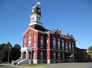
 Herkimer County Courthouse |
|
| administration | |
|---|---|
| US state : | new York |
| Administrative headquarters : | Herkimer |
| Address of the administrative headquarters: |
109 Mary St. Suite 1310 Herkimer, NY 13350 |
| Foundation : | February 16, 1791 |
| Made up from: | Montgomery County |
| Area code : | 001 315 |
| Demographics | |
| Residents : | 64,519 (2010) |
| Population density : | 17.6 inhabitants / km 2 |
| geography | |
| Total area : | 3,776.1 km² |
| Water surface : | 120.4 km² |
| map | |
| Website : www.herkimercounty.org | |
Herkimer County is a county in the US state of New York in the United States . At the 2010 census , the county had 64,519 residents and a population density of 17.6 people per square kilometer. The county seat is Herkimer .
geography
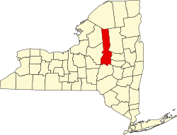
Herkimer County is located in northeast New York State. It is a hilly, in the north mountainous, heavily forested ground moraine landscape with a large number of mostly elongated lakes , which was formed in the last ice age. The most densely populated part of the county is in the south, while the northern part is almost uninhabited.
The county covers an area of 3,776.1 square kilometers, of which 120.4 square kilometers are water. The most important watercourse is the Mohawk River , which crosses the southern area of the county from west to east and forms the Mohawk Valley , in whose area the towns of Frankfort, Herkimer and Little Falls as well as the Villages Mohawk and Ilion are located. The so-called Herkimer diamonds , clear, double-ended quartz crystals , are also found in this area . North of the Mohawk Valley, the land rises in several stages and forms a mountainous plateau from about 300 to 500 meters high and individual mountain peaks between about 750 and 1000 meters high.
Surrounding areas
| Lewis County | St. Lawrence County | St. Lawrence County |
|
Lewis County Oneida County |

|
Hamilton County Fulton County |
| Madison County | Otsego County | Montgomery County |
history
The settlement of today's Herkimer County took place first along the Mohawk River. Little Falls, a colony of settlers from the Electoral Palatinate , was founded around 1722 . Until the end of the War of Independence, they were practically the only settlers in this area; but they were divided into several settlements. During the British-French War from 1756 the settlement was raided twice and some residents were killed or taken away as prisoners of war. The settlement was also attacked several times during the War of Independence , and buildings and fields were destroyed. In September 1778 the German Flats, founded in 1772, was taken by 300 British soldiers and around 150 allied Indians, the buildings destroyed and the cattle killed; two residents were killed. Then a fortified fort was built at German Flats and at Danube, but they remained unaffected by later fighting.
After the end of the War of Independence in 1778, the settlement proceeded rapidly; about 10,000 settlers from the New England states and the east coast settled in the area of the county within the next 15 years, particularly in the south and in the center. As the population increased, a state administration became necessary. So the county was formed on February 16, 1791. It was named after Nicholas Herkimer , a brigadier general of the state militia during the American War of Independence , and the son of Palatine immigrants from Sandhausen near Heidelberg .
According to the customs of the time, the county was initially responsible for the administration of a very large area, which was further subdivided as the population increased. So Onondaga County was separated in 1794, Oneida County and part of Chenango County followed in 1798. The later Hamilton County changed affiliation in 1797 and was added to Montgomery County. Finally, in 1816, the towns of Richfield and Plainfield, which had previously been part of Otsego County, were added to Herkimer County when Winfield was formed.
With the construction of the Erie Canal , which was completed in 1825, and later the construction of the lines of the Mohawk and Hudson Railroad (from 1831) and the West Shore Railroad , all of which ran through the Mohawk Valley, new industrial centers and production facilities arose along these transport routes between the centers of the east coast and the Great Lakes in the west.
Since the production in these centers was primarily a matter of refining local products, the county's economy remained largely unaffected during the civil war , the Great Depression of 1929 and the Second World War . The decline of the railway lines in the 1950s and 1960s also left the industry unaffected, because the new construction of expressways through the Mohawk Valley only changed, not reduced, the means of transport. Since the 1980s, tourism has been increasingly used as a source of income, which connects the vastness of the northern hinterland of the county with the good transport links of the Mohawk Valley.
Two locations have National Historic Landmark status , the New York State Barge Canal and the Mohawk Upper Castle Historic District . A total of 62 buildings and sites in the county are registered in the National Register of Historic Places (as of February 18, 2018).
Population development
| year | 1800 | 1810 | 1820 | 1830 | 1840 | 1850 | 1860 | 1870 | 1880 | 1890 |
|---|---|---|---|---|---|---|---|---|---|---|
| Residents | 14,479 | 22,046 | 31,017 | 35,870 | 37,477 | 38,244 | 40,561 | 39,929 | 42,669 | 45,608 |
| year | 1900 | 1910 | 1920 | 1930 | 1940 | 1950 | 1960 | 1970 | 1980 | 1990 |
| Residents | 51,049 | 56,356 | 64,962 | 64.006 | 59,527 | 61,407 | 66,370 | 67,633 | 66,714 | 65,797 |
| year | 2000 | 2010 | 2020 | 2030 | 2040 | 2050 | 2060 | 2070 | 2080 | 2090 |
| Residents | 64,427 | 64,519 |
cities and communes
In addition to the independent municipalities listed below, there are several villages in Herkimer County that are co-administered by the respective higher-ranking towns .
| Locality | status | Population (2010) |
Total area [km²] |
Land area [km²] |
Population density [inhabitants / km²] |
founding | Specialty |
|---|---|---|---|---|---|---|---|
| Columbia | town | 1,580 | 90.9 | 90.8 | 17.4 | June 8, 1812 | |
| Danube | town | 1,039 | 76.7 | 76.0 | 13.7 | Apr 7, 1817 | |
| Fairfield | town | 1,627 | 107.4 | 107.0 | 15.2 | 19 Feb 1796 | |
| Frankfort | town | 7,636 | 94.6 | 94.3 | 87.0 | Feb 5, 1796 | |
| German flatts | town | 13,258 | 88.6 | 87.3 | 151.9 | 24 Mar 1772 | Founded as a district; appointed town on March 7, 1788 |
| Herkimer | town | 10.175 | 83.5 | 82.0 | 124.1 | 7th Mar 1788 | County Seat |
| Litchfield | town | 1,513 | 77.8 | 77.7 | 19.5 | Feb 5, 1796 | |
| Little Falls City | City | 4,946 | 10.3 | 9.9 | 500.0 | 1895 | |
| Little Falls | town | 1,587 | 58.3 | 57.9 | 27.4 | Feb 16, 1829 | |
| Manheim | town | 1,587 | 76.9 | 75.5 | 21.0 | Apr 7, 1817 | |
| Newport | town | 2,302 | 84.1 | 82.9 | 27.8 | Apr 7, 1806 | |
| Norway | town | 762 | 92.9 | 92.1 | 8.3 | Apr 10, 1796 | |
| Ohio | town | 1.002 | 796.6 | 780.5 | 1.3 | Apr 11, 1823 | |
| Russia | town | 2,587 | 156.5 | 147.5 | 17.5 | Apr 7, 1806 | |
| Salisbury | town | 1,958 | 281.0 | 278.1 | 7.0 | Apr 7, 1817 | |
| Schuyler | town | 3,420 | 104.2 | 103.3 | 33.1 | Apr 10, 1792 | |
| Strong | town | 757 | 82.5 | 82.4 | 9.2 | 18 Mar 1828 | |
| Warren | town | 1,143 | 98.7 | 97.9 | 11.7 | Feb 5, 1796 | |
| Webb | town | 1,807 | 1254.3 | 1171.4 | 1.5 | 1896 | |
| Winfield | town | 2,086 | 61.3 | 61.2 | 34.1 | Apr 17, 1816 |
literature
- John Homer French: Gazetteer of the State of New York . RP Smith, Syracuse, NY 1860 ( PDF 63.8 MB , accessed June 15, 2016).
- Franklin Benjamin Hough: Gazetteer of the State of New York . 1st volume. A. Boyd, Albany, NY 1873, pp. 333 ff . ( PDF 58.3 MB , accessed June 15, 2016).
Web links
Individual evidence
- ^ Herkimer County in the Geographic Names Information System of the United States Geological Survey , accessed June 16, 2016
- ^ Mineralienatlas - Herkimer Diamant , accessed on June 23, 2016
- ↑ Listing of National Historic Landmarks by State: New York . National Park Service , accessed February 18, 2018.
- ↑ Search mask database in the National Register Information System. National Park Service , accessed February 18, 2018.
- ↑ Population 1810-2010 according to census results
- ↑ Population data from the 2010 US Census in the American Factfinder
- ↑ John Homer French: Gazetteer of the State of New York . RP Smith, Syracuse, NY 1860, pp. 336 ff . (unless otherwise stated)
Coordinates: 43 ° 28 ′ N , 74 ° 54 ′ W


