Ulster County
 Ulster County Courthouse |
|
| administration | |
|---|---|
| US state : | new York |
| Administrative headquarters : | Kingston |
| Foundation : | 1683 |
| Demographics | |
| Residents : | 177,749 (2000) |
| Population density : | 60.9 inhabitants / km 2 |
| geography | |
| Total area : | 3006 km² |
| Water surface : | 89 km² |
| map | |
| Website : www.co.ulster.ny.us | |
Ulster County is a county in the state of New York in the United States . At the 2000 census , the county had 177,749 residents and a population density of 61 people per square kilometer. The county seat is Kingston .
history
The county was founded on November 1, 1683 and named in honor of James II , who had been Earl of Ulster since 1659 .
Eight places in the county have National Historic Landmark status . A total of 176 buildings and sites in the county are registered in the National Register of Historic Places (as of February 21, 2018).
geography
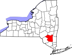
The county covers an area of 3,006 square kilometers, of which 89 square kilometers, or 2.95 percent, is water. It is located in the southeastern part of the state, south of Albany , but still west of the Hudson River . Most of the county falls within the range of the Catskill Mountains and the Shawangunk Ridge . Ulster County has several wildlife sanctuaries and state forests, including Minnewaska State Park , Mohonk Preserve , Sundown State Park , VerNooykill State Forest, Witches Hole State Forest and Shawangunk Ridge State Forest, and Sam's Point Preserve , which is home to VerKeerderkill Falls .
The highest point in the county is Slide Mountain , the summit of which is 1,274 m above sea level.
The New York State Thruway runs north-south on Interstate 87 through the county and connects the area with New York City and its surroundings.
Cities and towns
- Accord
- Big Indian
- Clintondale
- Cragsmoor
- Denning
- East Kingston
- Ellenville
- Esopus
- Gardiner
- Glasco
- Hardenburgh
- High falls
- Highland
- Hillside
- Hurley
- Kerhonkson
- Kingston
- Lake Katrine
- Lincoln Park
- Lloyd
- Malden
- Marbletown
- Marlborough
- Milton
- Napanoch
- New Paltz
- olive
- Phenicia
- Pine Hill
- Plattekill
- Port Ewen
- Rifton
- Rochester
- Rosendale Village
- Rosendale
- Saugerties South
- Suckers
- Shandaken
- Shawangunk
- Shokan
- Stone Ridge
- Tillson
- Ulster
- Walker Valley
- Wallkill
- Wawarsing
- West Hurley
- Woodstock
- Zena
Web links
Individual evidence
- ↑ GNIS-ID: 974153. Retrieved on February 22, 2011 (English).
- ↑ Charles Curry Aiken, Joseph Nathan Kane: The American Counties: Origins of County Names, Dates of Creation, Area, and Population Data, 1950-2010 . 6th edition. Scarecrow Press, Lanham 2013, ISBN 978-0-8108-8762-6 , p. 307 .
- ↑ Listing of National Historic Landmarks by State: New York . National Park Service , accessed February 21, 2018.
- ↑ Search mask database in the National Register Information System. National Park Service , accessed February 21, 2018.
Coordinates: 41 ° 53 ′ N , 74 ° 16 ′ W


