US Highway 9
| map | |
|---|---|

|
|
| Basic data | |
| Overall length: | 1540 mi / 2478 km |
| Opening: | 1926 |
| States: |
Delaware New Jersey New York |
| Starting point: |
|
| End point: |
|
| Important cities: |
New York City , NY Albany , NY |
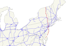
US Highway 9 is a highway in the United States that runs in a north-south direction through the US states of Delaware , New Jersey, and New York . In addition to US Route 10 , US Route 9 is one of only two US highways with a ferry connection along its route. The south end is an intersection with US Route 13 and is located in Laurel , Delaware. In the north the road ends in a dead end near the Canadian border . If you want to cross the Canadian border, you have to take the turn-off to Interstate 87 in Champlain .
Most of the US 9, with a few exceptions in the population centers, has two lanes. The main exception is the section in Middlesex and Monmouth Counties in central and northern New Jersey. In this region, the road runs parallel to US Route 11 and has four or six lanes with separate lanes. Other exceptions run in the state of New York with similar sections, at Albany the road to the expressway has been expanded. In New Jersey and New York, US 9 runs largely parallel to the Garden State Parkway or Interstate 87
course
Delaware
At its southern end, US 9 runs east to west in Sussex County. It begins its course as a junction of US Route 13 in Laurel and passes Georgetown east to Lewes to Cape May . The Lewes Ferry , which is part of US 9, crosses Delaware Bay there . This section of the route was created by the expansion of Delaware Route 28 between Laurel and Georgetown and Delaware Route 18 between Georgetown and Lewes, which were replaced by it.
New Jersey
At Cape May, US 9 runs parallel to the Garden State Parkway through the suburbs of Atlantic City until they briefly converge at the crossing of the mouth of the Mullica River . Then the road runs independently along the coast until it joins the Garden State Parkway again at the crossing of the Toms River . After crossing the river, the two roads separate and US 9 then turns inland towards New York. The road has separate lanes from Lakewood . After the Edison Bridge over the Raritan River , the road in Woodbridge merges with US Highway 1 . There it initially runs along Newark Liberty International Airport , and US 9 leaves New Jersey via the Pulaski Skyway along with Route 1 and Interstate 95 over the George Washington Bridge .
new York
After the bridge, the street at the northern tip of Manhattan reaches New York City via the toll-free Broadway Bridge , where it forms part of Broadway . After the road has crossed the Bronx , it leaves the city and enters Westchester County . There it partially simulates the course of the old Albany Post Road . Along the Hudson River , US 9 is a busy road that connects many suburbs and passes National Historic Landmarks like Sunnyside and Kykuit. The road between Croton-on-Hudson and Peekskill is called the Croton Expressway. This section ends at Annsville Circle at the intersection with US 20 and US 202 , then US 9 again runs in two lanes along the old Poststrasse. At Fishkill , the road passes the Van Wyck Homestead Museum and becomes a six-lane, two-way street on the Poughkeepsie city limits . From Poughkeepsie the number of lanes will be reduced to 4. At the junction of St. Andrews Road on the city limits to Hyde Park , the road finally reduces to 2 lanes. At Red Hook , the road turns inland and remains a two-lane country road through Columbia County to the outskirts of Hudson . In Rensselaer County , the road widens again at the turn for I-90 and joins in Albany with the US 20 . There she crosses the Hudson River over the Dunn Memorial Bridge . During the course of the road through Albany, US 9 is a busy road that connects the city center with the northern suburbs. Commuters use the roads as far as Saratoga Springs and Lake George on the border with Adirondack Park . The section through this park is the least traveled part of the entire road. In the park, the road becomes two-lane again, because when crossing the almost 150 km long section through the forest wilderness of the Adirondack Park, the road only leads through a few isolated villages and hamlets. After the park, the road on the west bank of Lake Champlain to the city limits of Plattsburgh runs parallel to Interstate 87. While the Interstate makes a loop around the city, the US 9 runs directly on the west bank of the lake and through the city. After Plattsburgh, the two roads are again very close to each other until the US 9 ends in a dead end at Champlain near the Canadian border.
Web links
- Delaware Highways - US 9
- NJDOT - US 9 line graph for the US 9 New Jersey section of the New Jersey Department of Transportation
- New Jersey Highways - US 9
- Capital Highways - Mid-Crosstown Arterial
Individual evidence
- ↑ US Highways ( Memento of the original of May 13, 2007 in the Internet Archive ) Info: The archive link was automatically inserted and not yet checked. Please check the original and archive link according to the instructions and then remove this notice.

