Thames Barrier
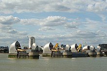
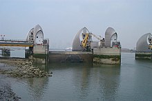
The Thames Barrier is one of the world's largest storm surge barriers . It is located on the River Thames in London district of Woolwich . Their main job is to protect London from exceptionally high tides in the North Sea , especially storm surges .
Technical specifications
The Thames Barrier has a total length of 520 meters and consists of ten pivoting gates. In order not to hinder shipping traffic, they are lowered to the bottom of the Thames when open. Ships with a draft of up to 16 meters can then easily pass the barrage. The four middle gates through which the shipping traffic runs are each 60 meters wide, 10.5 meters high and each weigh 1500 tons. If a storm surge threatens, the gates can be closed within 15 minutes. This also makes the Thames Barrier unique, as most comparable barriers need several hours to close the gates.
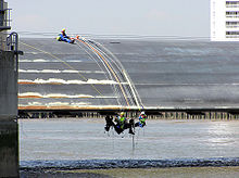
The gates are closed once a month as part of the maintenance work.
history
Current barrage
Planning for the Thames Barrier began after the Dutch storm flood in 1953, which killed 307 people in Great Britain alone.
Construction of the barrage began in 1974, and Queen Elizabeth II inaugurated it on May 8, 1984. The construction costs amounted to 534 million pounds . The barrier was used 184 times as flood protection for London by March 2019.
Plans for another barrage
At the beginning of 2005, plans were announced that the Thames Barrier would be replaced by a new barrier from 2030. This is to be built over a length of around 16 kilometers between Sheerness and Southend directly into the Thames estuary. One reason for this is the concern that the Thames Barrier will not be able to withstand future severe storm surges. More importantly, the new barrage would also protect the eastern suburbs of London and the Medway Towns , which is currently not the case.
Thames Barrier Park
In 2000, the Thames Barrier Park, designed by Alain Provost , opened in Silvertown . It was commissioned by the London Docklands Development Corporation in 1995 and has been managed by the London Development Agency since 1998 . It lies on the sealed, toxic remains of a dye works and is judged to be one of the most exciting English parks in recent years.
See also
Web links
- Thames Barrier in the Encyclopaedia Britannica online (graphic representation of the functionality, English)
- Thames Barrier. In: Structurae
Individual evidence
- ↑ Aisha Gani, London flood alerts in place as 'astronomical' tides hit Thames in: The Guardian , February 12, 2016, accessed February 12, 2016
- ↑ 10-mile Thames flood barrier plan. In: BBC News. January 10, 2005 (English).
- ↑ http://www.london.gov.uk/priorities/housing-land/land-assets/thames-barrier-park
- ↑ Janet Waymark 2003. Modern garden design. Innovation since 1900. London, Thames and Hudson, 209.
|
upstream Emirates Air Line |
River crossings of the Thames |
Downriver Woolwich Ferry |
Coordinates: 51 ° 29 ′ 50 ″ N , 0 ° 2 ′ 13 ″ E


