Bridgeport (Connecticut)
| Bridgeport | ||
|---|---|---|
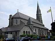
 Clockwise: Downtown, Bridgeport & Port Jefferson Ferry, United Congregational Church, St Patrick's Church, PT Barnum Museum |
||
 seal |
 flag |
|
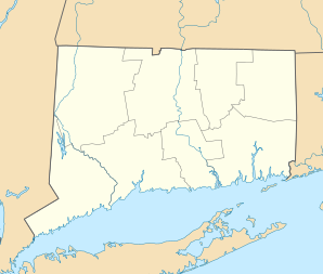
| Location of Bridgeport in Connecticut | ||
|
|
||
| Basic data | ||
| Foundation : | 1821 | |
| State : | United States | |
| State : | Connecticut | |
| County : | Fairfield County | |
| Coordinates : | 41 ° 11 ′ N , 73 ° 12 ′ W | |
| Time zone : | Eastern ( UTC − 5 / −4 ) | |
|
Inhabitants : - Metropolitan Area : |
144,000 (as of 2016) 944,177 (as of 2016) |
|
| Population density : | 3,478.3 inhabitants per km 2 | |
| Area : | 50.2 km 2 (approx. 19 mi 2 ) of which 41.4 km 2 (approx. 16 mi 2 ) is land |
|
| Height : | 1 m | |
| Postcodes : | 06600-06699 | |
| Area code : | +1 203 | |
| FIPS : | 09-08000 | |
| GNIS ID : | 0205720 | |
| Website : | www.ci.bridgeport.ct.us | |
| Mayor : | Joe Ganim | |
 Bridgeport train station |
||
With around 144,000 inhabitants (2016 estimate, US Census Bureau ), Bridgeport is the largest city in the US state of Connecticut and the seat of the administration of Fairfield County . The urban area has a size of 50.2 km².
Parts of the old town are registered as Bridgeport Downtown North Historic District and Bridgeport Downtown South Historic District in the National Register of Historic Places and are under ensemble protection .
The Remington company , a well-known manufacturer of metal alloys and weapons, was founded there on August 9, 1867, which gave the city enormous economic growth during the Russian Revolution and in both World Wars .
history
The first manned powered flight by the German aircraft pioneer Gustav Weißkopf took place in Bridgeport on August 14, 1901 .
Population development
|
|
|
|
religion
Bridgeport is the seat of the Roman Catholic Diocese of Bridgeport . Episcopal Church is the St. Augustine Cathedral. It was completed as a parish church in 1868 and made a cathedral in 1953 with the establishment of the diocese .
schools
|
|
|
economy
The metropolitan area of Bridgeport generated a gross domestic product of 102.4 billion US dollars in 2016, making it 37th among the metropolitan areas of the United States. The unemployment rate in the metropolitan region was 4.2 percent and was thus slightly above the national average of 3.8 percent (as of March 2018). The personal per capita income in 2016 was $ 106,666, making Bridgeport the highest income level of any metropolitan area in the country.
traffic
The Interstate 95 , the Merritt Parkway , the Connecticut Routes 8 and 25 , the US Route 1 and the Boston Post Road passing through the city. There is a ferry service to Port Jefferson in the US state of New York . The Amtrak and Metro North trains stop at Bridgeport Station.
Stadion
The Bridgeport Arena at Harbor Yard is a multi-purpose arena that seats 8281 people. This is where the home games of the Bridgeport Sound Tigers ice hockey team are played. The arena was built at The Ballpark at Harbor Yard .
Climate table
| Bridgeport, Connecticut | ||||||||||||||||||||||||||||||||||||||||||||||||
|---|---|---|---|---|---|---|---|---|---|---|---|---|---|---|---|---|---|---|---|---|---|---|---|---|---|---|---|---|---|---|---|---|---|---|---|---|---|---|---|---|---|---|---|---|---|---|---|---|
| Climate diagram | ||||||||||||||||||||||||||||||||||||||||||||||||
| ||||||||||||||||||||||||||||||||||||||||||||||||
|
Average monthly temperatures and rainfall for Bridgeport, Connecticut
|
|||||||||||||||||||||||||||||||||||||||||||||||||||||||||||||||||||||||||||||||||||||||||||||||||||||||||
Personalities
sons and daughters of the town
- Roger MacBride Allen (born 1957), science fiction writer
- Art Baron (* 1950), jazz trombonist
- Richard Belzer (born 1944), actor
- Big Bill Bissonnette (1937–2018), jazz musician and music producer
- Eric Blau (1921–2009), writer
- Alexandra Breckenridge (* 1982), actress
- Adriana Caselotti (1916–1997), singer and voice actress
- Dan Curtis (1928–2006), film director and film and television producer
- Brian Dennehy (1938-2020), actor
- Robert A. Hurley (1895–1968), politician
- Alfred James Jolson (1928–1994), Bishop of the Catholic Church
- Theodore D. Judah (1826–1863), railroad engineer, initiator of the Central Pacific Railroad
- Joe Killian (1927-2013), jazz musician
- Robert Kowalski (* 1941), computer scientist and logician
- Larry Kramer (1935–2020), author and playwright
- Edwin Herbert Land (1909–1991), physicist
- Mike LeDonne (* 1956), jazz pianist
- Albert Lester Lehninger (1917–1986), biochemist and professor of physiological chemistry
- Robert W. Lowndes (1916-1998), science fiction writer and editor
- Barbara McDermott (1912-2008), survivor of the Lusitania sinking
- Angus MacLise (1938–1979), drummer, composer, poet and visual artist
- John Mayer (* 1977), guitarist / singer-songwriter
- Edward Warren Miney (1926-2006), demonologist
- John Mitchum (1919-2001), actor
- Robert Mitchum (1917–1997), actor
- Tony Musante (1936-2013), actor
- Alyssa Naeher (* 1988), soccer player
- Jerome Namias (1910–1997), meteorologist
- Roy Neuberger (1903-2010), art patron
- Jeff Parker (* 1967), guitarist
- John Ratzenberger (* 1947), actor
- Charles Schnee (1916–1963), screenwriter and film producer
- Joseph Selling (* 1945), Roman Catholic theologian
- Kurt Schrader (* 1951), politician
- BP Schulberg (1892–1957), film producer
- Wilbur L. Scoville (1865-1942), pharmacologist
- James C. Shannon (1896–1980), politician
- Samuel Simons (1792–1847), politician
- Holly Solomon (1934–2002), art dealer and actress
- Rick Sternbach (* 1951), illustrator for Star Trek
- Charles Stratton (1838–1883), circus performer and actor
- Laura Tătulescu (* 1981), opera singer
- Marnie Weber (* 1959), artist
Others
- Circus owner Phineas Taylor Barnum was mayor of Bridgeport twice in the 1870s.
Web links
- History of Bridgeport (English)
- The story in Postcards (English)
Individual evidence
- ^ Dispute over the first powered flight: US governor honors aviation pioneer Weißkopf Bayerischer Rundfunk Franken, June 27, 2013
- ^ US Department of Commerce, BEA, Bureau of Economic Analysis: Bureau of Economic Analysis. Retrieved July 4, 2018 (American English).
- ^ Bridgeport-Stamford-Norwalk, CT Economy at a Glance. Retrieved July 5, 2018 .
- ^ US Department of Commerce, BEA, Bureau of Economic Analysis: Bureau of Economic Analysis. Retrieved July 5, 2018 (American English).

