Williamstown, Massachusetts
| Williamstown | |
|---|---|
 |
|
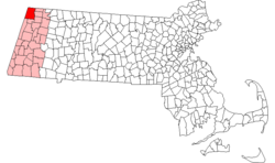
| Location in Massachusetts | |
| Basic data | |
| Foundation : | 1749 |
| State : | United States |
| State : | Massachusetts |
| County : | Berkshire County |
| Coordinates : | 42 ° 43 ′ N , 73 ° 12 ′ W |
| Time zone : | Eastern ( UTC − 5 / −4 ) |
| Residents : | 8,424 (as of: 2000) |
| Population density : | 69.4 inhabitants per km 2 |
| Area : | 121.5 km 2 (about 47 mi 2 ) of which 121.4 km 2 (about 47 mi 2 ) is land |
| Height : | 194 m |
| Postal code : | 01267 |
| FIPS : | 25-79985 |
| GNIS ID : | 0619430 |
| Website : | www.williamstown.net |
Williamstown (formerly West Hoosuck Plantation ) is a place in the extreme northwest of Massachusetts , on the border with Vermont in the north and New York in the west. The place is the location of Williams College and the Sterling and Francine Clark Art Institute . The prestigious Tony Award-winning Williamstown Theater Festival has been held there since 1955 .
geography
The place is at the confluence of the Green River in the Hoosic River . To the west, the Taconic Range forms the border with New York, where Taconic State Park is located . In the south, next to Brodie Mountain , Mount Greylock rises . The place is on the Appalachian Trail . To the north is the Green Mountain National Forest .
history
The place was first established under the name West Hoosac in 1749. In 1756 a fort was built from a log house with a palisade. The place gained its independence in 1765 under its current name, named after Ephraim Williams , who gave the place extensive financial donations on condition that it was named after him and opened a school in 1791, which became Williams College in 1793. The main source of income for the inhabitants was agriculture ( milk production , sheep breeding and wool production). It came saw and flour mills added later, larger mills such as the Walley Mill , the textiles produced. Furthermore, were cords produced. After the opening of the railway , tourists reached the place, with the result that many hotels and restaurants were opened. The 1753 House , a popular event location, commemorates the founding of the place .
traffic
The place is on US Highway 7, which runs from north to south . The Massachusetts State Route 2 begins at the border of New York and is called after the short common route with Highway 2 Taconic Trail . In addition, Massachusetts State Route 43 branches off from Route 2 to Hancock here.
sons and daughters of the town
- William Livingston Alden , author and theosophist
- Florence Bascom , geologist
- Bernard Blair , politician
- Albert Cummings , blues guitarist
- Carol Holloway , actress
- Ronold WP King , physicist
- John Bennett Perry , actor
- Matthew Perry , actor
- Charles Stebbins , politician
- Ezra Stoller , photographer
Web links
Individual evidence
- ^ Charlotte Pease Davis (compiler): Directory of Massachusetts Place Names. 1st edition. np: Massachusetts Daughters of the American Revolution, 1987.
- ^ Tony Award: "Winners 2002: Regional Theater Tony Award" .
- ↑ http://wtfestival.org/about/
