Hancock, Massachusetts
| Hancock | ||
|---|---|---|
 Taylor Memorial Library |
||
| Location in Massachusetts | ||
|
|
||
| Basic data | ||
| Foundation : | July 2, 1776 | |
| State : | United States | |
| State : | Massachusetts | |
| County : | Berkshire County | |
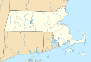
| Coordinates : | 42 ° 32 ′ N , 73 ° 19 ′ W | |
| Time zone : | Eastern ( UTC − 5 / −4 ) | |
| Residents : | 717 (as of 2010) | |
| Population density : | 7.7 inhabitants per km 2 | |
| Area : | 92.375 km 2 (approx. 36 mi 2 ) of which 92.553 km 2 (approx. 36 mi 2 ) is land |
|
| Height : | 534 m | |
| Postal code : | 01237 | |
| Area code : | +1 413 | |
| FIPS : | 25-28180 | |
| GNIS ID : | 619421 | |

Hancock is a town in the west of the US state Massachusetts . In the United States Census 2010, the city in Berkshire County had 717 inhabitants.
geography
Geographical location
According to the United States Census Bureau , Hancock has a total area of 69.2 km². The town has an elongated north-south orientation and is located in the west of the state of Massachusetts, along the border with the state of New York . To the south is the Hancock Shaker Village; here the US Highway 20 crosses the area of the town. In the north, the West Branch Green River takes the water from the Forebusch Wildelife Sanctuary and drains into the Green River . In the south there are only a few streams and two small lakes. Hancock is very hilly and it is not possible to cross the area of the town from north to south. To do this, a detour must be made via the state of New York. In the valleys the soil is very fertile and wheat, maize and potatoes are grown. Maple trees , birches , ash trees and elms grow in the forests .
Neighboring communities
Hancock is bordered by Richmond to the south, Pittsfield to the southeast , Lanesborough to the east, New Ashford to the northeast, and Williamstown to the north .
climate
The mean mean temperature in Hancock ranges from −7 ° C (20 ° Fahrenheit ) in January to 21 ° C (70 ° Fahrenheit) in July. Snowfalls between October and May are up to 40 cm (16 inches ), about twice the mean snow depth in the United States. The daily sunshine duration is at the lower end of the range in the USA.
history
The Hancock Grant was given in 1760 to Asa Douglass, Timothy Hurlburt, John Ashley, and Josiah Dean. Berkshire County was the last county to be settled in Massachusetts. Settlement began in April 1762; the area was called "Jericho" at the time. The first settler was the lawyer Asa Douglass. The first settlers settled in the northern part of the town. In 1761 Charles Goodrich received a grant for the southern part of the town. In 1764, his nephew Daniel Goodrich was the first to settle there, followed by other members of the family. The Osborn and Talcot families followed. The town was named after John Hancock when it was founded on July 2, 1776 . Two settlement areas formed independently of one another: Hancock in the north and the Hancock Shaker Village in the south. The first town meeting took place on August 21, 1776 at Asa Douglass' home. He was then also appointed representative of the town in the General Court of Massachusetts .
In 1778, Hancock was also drawn into the American Revolutionary War . In the town meeting, according to the instructions of the General Court, support for the soldiers was decided, and Asa Douglass was given supervision of the town's ammunition dump. The cemetery was later set up on the site. During the revolution, the town's population was divided into two parts, some stuck to their home country England, others already felt like Americans. In the elections in 1780, 32 residents voted for John Hancock and two for James Bowdoin .
Hancock Shaker Village


The Hancock Shaker Village is on the Pittsfield border and partially in the Pittsfield area. The community was founded in 1792 and called itself City of Peace . The Gooderich, Osborn and Talcot families, who settled in the southern part of Hancock, became Shakers and on January 17, 1791 the first church meeting was held. They ran agriculture and worked as craftsmen. The Gooderichs were the first family in the community in 1791, John Deming's family became the second family that same year, and the Talcots became the Western family in 1792. An Eastern family was added in 1793. In the years 1820 to 1830 the community had its greatest bloom when about three hundred members lived there. Hancock was the third Shaker ward in America and later became a bishopric .
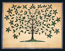
The community also included painters Polly Collins and Hannah Cohoon . Cohoon's Tree of Light, a religious symbol of the Shaker movement for life and eternal growth, was dated to the year 1845.
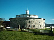
Today the Hancock Shaker Village is a museum with 20 original Shaker buildings, the most famous of which is the round barn built in 1826 . The museum has costumed performers and a large collection of Shaker furniture , which is shown in temporary exhibitions.
Religions
A Baptist congregation was organized in 1772 with fifteen members. There was also a “Friends Meetinghouse” in Hancock.
Population development
| year | 1800 | 1810 | 1820 | 1830 | 1840 | 1850 | 1860 | 1870 | 1880 | 1890 |
|---|---|---|---|---|---|---|---|---|---|---|
| Residents | 1187 | 984 | 789 | 816 | 882 | 642 | 506 | |||
| year | 1900 | 1910 | 1920 | 1930 | 1940 | 1950 | 1960 | 1970 | 1980 | 1990 |
| Residents | 451 | 465 | 464 | 361 | 332 | 445 | 455 | 675 | 643 | 628 |
| year | 2000 | 2010 | 2020 | 2030 | 2040 | 2050 | 2060 | 2070 | 2080 | 2090 |
| Residents | 721 | 717 |
education
Hancock has the Hancock Public Library and Hancock Elementary School with classes from kindergarten through sixth grade. Then the students attend the "Mount Greylock Regional High School" in Williamstown or the "Pittsfield High School" in Pittsfield.
Personalities
sons and daughters of the town
- Martin I. Townsend (1810–1903), lawyer and politician
Personalities who have worked on site
- Hannah Cohoon (1788–1864), artist
literature
- John Hayward: A Gazetteer of Massachusetts . John Hayward, Boston 1847, p. 166 ff . ( Book in PDF format at archive.org ).
- Elias Nason: A gazetteer of the state of Massachusetts . BB Russell, Boston 1874, p. 244 f . ( Book in PDF format at archive.org ).
Individual evidence
- ↑ United States Census 2010 ( Memento of the original from March 23, 2015 in the Internet Archive ) Info: The archive link was inserted automatically and has not yet been checked. Please check the original and archive link according to the instructions and then remove this notice.
- ^ A b c David Dudley Field, Chester Dewey, Berkshire Association (Mass.): A History of the County of Berkshire, Massachusetts, in Two Parts: The First Being a General View of the County; the Second, an Account of the Several Towns . SW Bush, 1829 ( books.google.com ).
- ↑ Climate, school and employment data at www.City-Data.com (English)
- ^ A b c d Full text of "Western Massachusetts; a history, 1636-1925". In: archive.org. Retrieved May 1, 2016 .
- ↑ a b c Stephen J. Paterwic: Historical Dictionary of the Shakers . Scarecrow Press, 2008, ISBN 978-0-8108-6255-5 ( books.google.com ).
- ^ History - Hancock Shaker Village. In: hancockshakervillage.org. Hancock Shaker Village, accessed May 1, 2016 (American English).
- ↑ Population 1800–2010 according to census results
