
Mount Everest
| Mount Everest | |
|---|---|
 North side, seen from the path to the base camp |
|
| height | 8848 m |
| location | Solukhumbu District (Nepal) , Tibet (China) |
| Mountains | Mahalangur Himal ( Himalaya ) |
| Coordinates | 27 ° 59 '16 " N , 86 ° 55' 29" E |
 |
|
| rock | Crystalline rocks , limestone |
| Age of the rock | Neoproterozoic - Ordovician , Tertiary |
| First ascent | May 29, 1953 by Edmund Hillary and Tenzing Norgay |
| Normal way | South route |
|
Virtual flight around Mount Everest |
|

The Mount Everest is a mountain in the Himalayas and with a height of over 8,848 meters (more precisely see heights ) of the highest mountain on earth. It is one of the 14 eight-thousanders and one of the Seven Summits . Mount Everest has been named after the British surveyor George Everest since 1856 . In Nepali the mountain is called Sagarmatha , in Tibetan Qomolangma (German pronunciation "Tschomolangma") and in Chinese and standard Chinese 珠穆朗瑪峰, Zhūmùlǎngmǎ Fēng .
Mount Everest is located in Mahalangur Himal in the region Khumbu in Nepal on the border with China ( Tibet Autonomous Region ); the western and south-eastern of its three summit ridges form the border. On the Nepalese side, it is part of the Sagarmatha National Park , which is a UNESCO World Heritage Site . On the north side it belongs to the Qomolangma National Nature Reserve , which corresponds to the UNESCO designated Qomolangma Biosphere Reserve .
Edmund Hillary and Tenzing Norgay succeeded on May 29, 1953, the first ascent of the "third pole". On May 8, 1978, Reinhold Messner and Peter Habeler climbed the summit for the first time without additional oxygen. To date (as of the end of 2018) the summit has been reached around 8,400 times by climbers. Over 300 climbers were killed on the way there or back.
While Mount Everest is the highest point above sea level , there are two other mountains that are known as the "highest mountain on earth" . Measured from the foot of the mountain, this is the Mauna Kea volcano in Hawaii , and the Chimborazo in Ecuador from the center of the earth .
Name of Mount Everest
In Nepali the mountain is called सगरमाथा Sagarmatha (“forehead of heaven”) and in Tibetan ཇོ་ མོ་ གླང་ མ Jo mo glang ma or Qomolangma (“mother of the universe”). The Chinese name珠穆朗玛峰 Zhūmùlǎngmǎ Fēng is a phonetic rendering of the Tibetan name. Their transcription Chomolungma in English is common in Europe today. The Tschomolungma used in German-language, especially older, texts has been superseded in favor of Chomolungma in more recent German-language sources.

Sir George Everest was head of the Great Trigonometric Survey of India and Surveyor General of India for many years . Under his successor Andrew Scott Waugh , the summit, initially referred to as "Peak b", was first measured from India in 1848; At that time, Nepal refused access to its territory. Further surveying work over distances of up to 200 km was followed by extensive, complex calculations by Radhanath Sikdar in the Computing Offices in Dehradun ; In 1852 he came to the conclusion that the summit, now known as "Peak XV" ("Summit 15"), was 29,002 feet (8840 m) higher than all other mountains known up to that point. Because of the great distances, last doubts about the accuracy of the measurements had to be dispelled, this result was not made known until 1856 by Andrew Waugh in a letter to the Royal Geographical Society . He named the mountain in honor of his predecessor as Mount Everest. The current pronunciation of Mount Everest is [ˈmaʊnt ˈɛvərɛst] , but Sir George pronounced his own surname [ˈiːvrɪst] .

The mountain was known as Gauri Sankar for a long time, especially in the German-speaking world . This was based on a misunderstanding by the German Himalayan pioneer Hermann von Schlagintweit . In 1855 he tried to explore Peak XV, which had just been calculated as the highest mountain on earth, but was unknown. From near Kathmandu he looked at the west side of the mountain and saw a mountain that lay in the direction of Everest and towered above all other mountains. This mountain was known to the Nepali as Gaurisankar, but Schlagintweit thought it was the mysterious Peak XV. Based on this error and from the rejection of the English name Mount Everest in favor of the "beautiful old name [s] Gaurisankar", this designation for the highest mountain in the world was included in the atlases in Germany and taught in schools. In 1903 it was established that the Gaurisankar is a different one, namely the 7145 m high Peak XX; its distance to Everest is 58 km.
Mythological meaning

Like basically all the distinctive peaks of the Khumbu region, Mount Everest is a sacred mountain for the Sherpas . In this people, Buddhism is paired with more original religions, especially animism and Bon . According to the Sherpas, ghosts and demons inhabit springs, trees and even the peaks. According to Buddhists, Mount Everest is the seat of Jomo Miyo Lang Sangma, one of the five "sisters of long life" who live on the five highest peaks of the Himalayas. Jomo Miyo Lang Sangma gives food to people.


According to legend, the great saint Padmasambhava , who brought Buddhism from India to Tibet, organized a race to the summit of Mount Everest. After Padmasambhava meditated on the summit for some time and fought with the demons, he was challenged by a lama of the Bon religion. It was about the question of which of the two is more powerful. The lama of the Bon religion set out in the night, carried by his magic drum, Padmasambhava only at daybreak. He won the race anyway because, sitting on a chair, a beam of light brought him directly to the summit. After waiting upstairs for some time, Padmasambhava left his chair and began to descend. The Bon Lama gave in and left his drum behind. To this day it is said that the ghosts beat the drum when an avalanche thunders down into the valley.
Because of this importance, the Sherpas perform a sacrificial ceremony, a so-called puja , before climbing . The Sherpas are convinced that a puja is absolutely necessary in order to avert disaster. This festival of sacrifice is indispensable for their peace of mind, and in general all western expedition participants take part in it, otherwise, according to the Sherpas' belief, the mountain gods would be angry, not only with the foreigners, but especially with the Sherpas who do this would have admitted.
Religious symbols such as mani stones and a stupa with prayer flags printed with mantras can be found at the foot of Mount Everest. On the way to the Everest base camp ( Mount Everest Trek ), at the Thokla Pass between Dingboche and Lobuche , a memorial was created for the victims of Everest. The dead are paid their last respects with a so-called stone man , a pile of piled stones, or a stele.
geology
Regional geological framework


Like the entire Himalayas , Mount Everest is a result of the alpine mountain formation . In the South Asian section of the Alpidic mountain belt, the convergence of the Indian plate and the Eurasian plate , which began around 90 million years ago in the Upper Cretaceous , led to the closure of the eastern Tethys and subsequently to the collision of the continental blocks of India and Asia from the Eocene around 50 million years ago . The much smaller Indian plate continues to slide beneath Eurasia at a rate of about three centimeters per year. Due to the thickening of the continental crust associated with the collision, Mount Everest is still growing, but only a few millimeters a year. The continuous uplift is caused by isostatic compensatory movements , which follow from the difference in density between the stacked crust of the earth in the area of the mountains and the denser earth mantle . The mountain root protruding into the earth's mantle receives a buoyancy , similar to a cork in water. However, the uplift is partially offset by erosion , the process that was ultimately also responsible for modeling the mountain out of the mountain body.
Geological structure and rocks
Due to intensive tectonic deformation (" folding ") under high pressure and high temperatures, the original rocks underwent a transformation when they were submerged in the lower levels of the earth's crust , with the degree of metamorphosis in the Everest massif generally decreasing from bottom to top. The lowest rock unit of the massif (above 5400 m ) consists mainly of highly medium-grade metamorphic rocks , especially dark, biotite-rich sillimanite - cordierite - gneisses , the protolithic age of which is estimated to be the late Neoproterozoic (more than 540 million years). These gneisses belong to the central crystalline zone of the Himalayas (also called Greater Himalayan Sequence or Higher Himalayan Crystalline Sequence ).
The gneisses on the upper “floor” of the crystalline zone are interspersed in many places with plutons and corridors made of light granite ( leuco granite). On Everest this is the so-called Everest-Nuptse-Granite (partly named after the neighboring mountain Nuptse ). In addition to the general granite-typical main mixes, it contains quartz , feldspar (here microcline or orthoclase and plagioclase ) and mica (here muscovite and biotite ) mainly tourmaline . The magma from which this granite emerged melted in the deeper structural levels of the crystalline sequence. The formation of the magma and the settlement of the granite bodies took place at the turn of the Oligocene - Miocene approx. 24 to 21 million years ago and in the Middle Miocene around 16 million years ago.
The lower part of the summit pyramid, from a height of about 7500 m , is made up of low-medium to low-grade metamorphic sedimentary rocks of the Cambrian , which are summarized under the name North Col Formation or Everest Series . These are mainly quartz-bearing mica slate , phyllite and chlorite slate . They are separated from the gneisses and granites of the central crystalline by the so-called Lhotse shear zone , but some granite dikes cross the shear zone and also penetrate the basal part of the North Col Formation. At around 8350 m , the North Col Formation is overlaid by an approx. 170 m thick sequence of coarse crystalline marble and slate, which is known as a yellow band due to its striking weathering color .
The actual summit area consists of Ordovician, slightly dolomitized , fine-grain limestone - the Qomolangma Formation . These limestones usually show clear signs of vigorous movement (their fine-grain structure is probably mainly due to dynamic recrystallization; see → Mylonite ). Calcite - porphyroclasts swim in the fine-grained, foiled base material or are “ flowed around ” by it in a characteristic way. Some of these "calcite eyes" are clearly identifiable in the thin section as relics of fossils (e.g. crinoid arm or stalk limbs). A few meters below the summit, samples with numerous fragments of crinoids, trilobites , ostracods and brachiopods have been collected, which apparently have undergone significantly less deformation and metamorphosis.
The Qomolangma formation is against the yellow band by the flat northeast incident Qomolangma Detachment limited ( "Tschomolangma-shearing area"), which in contrast to the Lhotse-shear zone as the warp is formed. Lhotse Shear Zone and Qomolangma Detachment are structural elements of the so-called South Tibetan Detachment System (" South Tibetan Shear Surface System "), an extensive fault system that separates the central crystalline from the phanerozoic , marine-sedimentary (typically weakly intermediate to unmetamorphic) Tethys-Himalayan sequence , adjacent to the north , to which the Qomolangma formation is also assigned, separates.
earthquake
The ongoing plate movements cause some very strong earthquakes in large parts of South and East Asia, which also affect Mount Everest. As a result of the severe earthquake on April 25, 2015 , the mountain was shifted three centimeters in a south-westerly direction, according to measurements by the Chinese Surveying, Mapping and Geoinformation (测绘 地理 信息 管理). The earthquake of May 12, 2015, however, had no impact on the location of the mountain. In the previous ten years, Everest had moved at an average speed of four centimeters per year in the opposite direction, to the northeast, and was raised by an average of 0.3 cm per year.
topography

The summit pyramid is modeled by erosion and huge glaciers . The three main ridges - west ridge, north / northeast ridge and southeast ridge - subdivide the summit into three main walls - southwest wall, north wall and east wall ( Kangshung flank ). In addition, the ridges separate the three glaciers that pour from Mount Everest and its neighboring peaks: Khumbu Glacier , Rongpu Glacier (also Rongbuk Glacier ) and Kangshung Glacier .
The southeast ridge and west ridge as well as their continuations form the further border between Tibet and Nepal. The southeast ridge connects Mount Everest with the 8516 m high Lhotse , the lowest point of this ridge is the 7906 m high South Col. The ridge continues from the Lhotse in the direction of Lhotse Shar ( 8415 m ) and Peak 38 ( 7591 m ). The west ridge initially runs out into a secondary peak - the so-called west shoulder - which drops to the Lho-La pass ( 6606 m ) and then into the mountain range of Khumbutse ( 6636 m ), Lingtren ( 6714 m ) and Pumori ( 7138 m ) continues. The northeast ridge on the Tibetan side aims from the summit over three rocky steps and three rock needles down to the eastern Rongpu Glacier. The north ridge branches off from it below the steps and above the needles at an altitude of 8420 m and connects Mount Everest via the lowest point on the north saddle ( 7005 m ) with the 7543 m high Changtse . The long ridge of the Nuptse ( 7861 m ), which is separated from Mount Everest by the Valley of Silence and the Khumbu Glacier, stretches from the Lhotse on the Nepalese side in a westerly direction .
The walls of Everest are structured differently. The southwest wall to the Valley of Silence has two prominent pillars. On the whole, it is steep (around 60–70 degrees). The north face is essentially divided by two high couloirs, the Norton Couloir and the Hornbein Couloir . The slope of the north wall varies by 40–45 degrees. The heavily glaciated east wall or Kangshung wall has three main pillars. It is very steep in the lower part (up to 80 degrees) and marked by hanging glaciers in the upper, less inclined part.
climate
The climatic conditions on Mount Everest are extreme. In January, the coldest month, the average temperature at the summit is -36 ° C and can drop to values as low as -60 ° C. Even in the warmest month, July, the temperatures do not rise above the frost line, the average temperature at the summit is then −19 ° C.

In winter and spring, winds from western directions prevail. The moisture-laden air condenses into a white, east-facing cloud (often falsely referred to as "snow plume"). Because of these clouds of clouds, the Himalayas were originally thought to be a chain of volcanoes. With the help of the cloud plume of Mount Everest, mountaineers also estimate the wind speed on the summit: At around 80 km / h it is at right angles to the summit, with higher levels it slopes down and with lower levels it slopes upwards. In winter, the southwest jet stream hits the summit and can cause wind speeds of up to 285 km / h. From June to September the mountain comes under the influence of the Indian monsoons . This is the time when most of the precipitation falls and heavy snowstorms shape the weather.
As in all high mountain regions, the weather can change rapidly . This also applies to the two climbing seasons in May and October. Sudden drops in temperature, storms and snowfalls of up to three meters per day are not unusual. Usually there are only a few days with stable weather in the respective season - the so-called "window days" - on which an ascent is most likely.
Various studies in the first decade after the turn of the millennium came to the conclusion that the ice masses in the area of Mount Everest are melting rapidly due to climate change . As a result, among other things, more and larger meltwater lakes are forming on the Khumbu Glacier , which hinder an ascent and increase the risk. Also, as a result of climate change, the melting of ice has thawed many of the 200 or so mountaineering bodies there from glaciers and ice fields.
fauna and Flora
The air pressure on the summit of Mount Everest is 325.4 hPa according to the barometric altitude formula and corresponds to almost a third of the normal pressure at sea level. This shifts the boiling point of water from 100 ° C under normal conditions to only 70 ° C, and the oxygen partial pressure of the air is only a third compared to sea level. In addition, there are extreme temperature fluctuations and strong winds. Only a few animals were able to adapt to this extremely hostile environment; flowering plants can no longer be found in the area of the eternal ice.
Euophrys omnisuperstes , a small representative of the jumping spiders (Salticidae), wasobservedby RWG Hingston as early as 1924 up to an altitude of 6700 m . Its nutritional basis remained a mystery for a long time. It was not until 1954 that it was discovered that they feed on flies and springtails (Collembola), which can be found up to an altitude of 6000 m . The latter live on fungi and lichens , which break down organic material that is blown in. In the Everest expedition carried out in 1924, lichens werecollectedbetween 4600 and 5500 m . Based on this, R. Paulson was able to identify around 30 species in 1925.
Of the vertebrates, only a few birds are able to permanently adapt to the extreme altitude. The strip goose ( Anser indicus ) adheres to heights of 5600 m on. Alpine crows ( Pyrrhocorax pyrrhocorax ) have even been observed on the 7,920 m high South Col, where they feed on refuse, but also on climbers who have died in an accident. The body of George Mallory , which was found at about 8,160 m , was probably also eaten by birds.
Height information and measurements

The height of Mount Everest has been determined in many measurements. This resulted in heights between 8844 and 8850 m . The measurement is difficult due to the altitude ( dead zone ) and the layer of ice on the summit. The ice layer on the summit is not included in the amount, as it is subject to strong fluctuations. The exact height must therefore relate to the height of the rock pedestal below. This was not yet possible with the first measurements. Another problem is the sea level as a reference parameter . Chinese measurements are based on the defined zero point of a level in Qingdao , Nepalese measurements from the zero point of a level in Karachi . The distance between the two locations is more than 6000 kilometers, and this different reference system alone results in significant differences. In addition, GPS altitude information is based on a simplified model of the earth, the reference ellipsoid of the World Geodetic System 1984 . In such measurements, the difference between the geoid and the reference ellipsoid must be taken into account, as was the case with the measurement in May 2004.
The information for the summit height of Mount Everest has been corrected several times since the first measurement in 1848. In 1856, data from six different surveying stations were used to calculate 8,840 m . The stations were, however, more than 150 kilometers away from the Everest massif, as the surveyors of the British Indian Survey were not allowed to enter Nepal. Until then, one saw the Dhaulagiri ( 8167 m ), the first eight-thousander to be discovered , and from 1838 the Kangchenjunga ( 8586 m ) as the highest mountain.


The altitude of 8,848 m, which was valid for a long time, was calculated as an average value by the Survey of India in 1954 from the measurement data from a total of twelve surveying stations. This information was confirmed by a Chinese expedition in 1975 - they found 8,848.13 m .
A height measurement carried out directly on the mountain by a Chinese-Italian expedition team in September 1992 as the first using modern means gave almost the same value at 8,848.82 m . The data used came from measurements with conventional theodolites as well as from laser measurements and GPS signals.
Very precise measurements with the help of several GPS receivers on May 5, 1999 showed an altitude of 8850 m . This information is based on the height of the rock pedestal. The thickness of the layer of ice and snow at the summit varies between one and three meters , depending on the season and the amount of rainfall during the monsoon season .
During a measurement in May 2004, eight radar reflectors were anchored at the summit, thus determining the height of the rock base. The respective height of the radar profiles was then determined. The thickness of the ice layer was then subtracted from this height. According to this measurement, Everest had a height of 8848.82 m , with an inaccuracy of ± 0.23 meters. This confirms the level from 1992.
Another measurement is from May 2005, again carried out by a Chinese expedition. It resulted in a height of 8844.43 m for the mountain , with an inaccuracy of ± 0.21 meters. It is about 3.7 meters lower than assumed since the Chinese measurement of 1975. However, like those from 1999 and 2004, the information only refers to the pure rock base. This investigation was undertaken from China's north side rather than the Nepalese south and lasted a year. Radar detectors as well as laser measuring devices and satellite positioning systems were used.
In 2020, China and Nepal re-measured the mountain together and determined a height of 8,848.86 m .
Ascent history

As the highest mountain on earth, Mount Everest is always an attractive destination. The first attempts at ascent were made in the 1920s, but it was not until May 29, 1953 that Edmund Hillary and Tenzing Norgay were the first to climb the summit. Numerous new routes have been opened since the 1960s. A Chinese expedition succeeded in climbing from the Chinese north side in 1960. On May 8, 1978, Reinhold Messner and Peter Habeler reached the summit for the first time without additional oxygen.
First attempts to climb
Francis Younghusband's British army expedition forcibly made its way through Tibet in 1904 to force the country to open its borders and grant trade privileges. J. Claude White also took the first detailed photograph of the eastern flank from Kampa Dzong (about 150 kilometers away).
1920s

The first ascent of Mount Everest by a British man was of great national importance in the United Kingdom. The British chemist, researcher in altitude medicine and mountaineer Alexander Mitchell Kellas summarized the prevailing opinion on February 22, 1916 in a letter to Sandy Wollaston , who, like Kellas, would later belong to the members of the first British expedition to Mount Everest:
"We missed both poles after ruling the seas for 300 years, and we are definitely not going to miss the chance to explore the area around Mount Everest after being the dominant power in India for 160 years [ For example, I would be proud to go there with 2 to 10 porters, or even alone, to give Britain this little bit of exploration. "
During the exploration and climbing expeditions, attempts were made to obtain approval from the Dalai Lama . It was not until the 1920s that he gave this permission to the Royal Geographical Society .
The first British exploration expedition was sent to the area in 1921. Here, however, it was not primarily about climbing the mountain, but about geological surveys, mapping of the area and an initial exploration of possible ascent routes. Participants in the expedition completed the survey of 31,000 square kilometers. In the course of this expedition, George Mallory discovered a practicable route to the summit from Lhakpa La , the previous standard north route through the valley of the eastern Rongpu glacier to the north saddle. A short-term ascent attempt failed on the north saddle due to the onset of the monsoon.
In 1922 no more topographical surveys were planned and the expedition was scheduled for the pre-monsoon period. The ascent attempts were made in small groups. The first attempt was made by Mallory, Somervell, Norton and Morshead without the use of supplemental oxygen. They set up a small camp at an altitude of 7600 m and continued the ascent the following day. Morshead had to stop the ascent very quickly, the other climbers reached an altitude of 8,225 m that day, a new world record for mountaineers.
The next attempt was made by George Ingle Finch , Geoffrey Bruce and the Gurkha Tejbir with oxygen bottles. Although they made good progress at first, due to strong winds they were only able to set up the camp at 7460 m. They could not continue the ascent until two days later. Since Tejbir did not have windproof clothing, he began to flag early. He collapsed at 7,925 m. Finch and Bruce sent him back to camp and continued their ascent. They came up to an altitude of 8,326 m, a new height record.
Another attempt to climb was made by Mallory, Somervell and Crawford. Mallory was impressed by Finch's achievements - he had come higher than himself and was also closer to the summit horizontally - and now wanted to take oxygen with him as well. On the ascent of Camp III, an avalanche broke off and carried away seven porters that could not be rescued. The expedition was over.
In 1924 the British returned. Mallory and Andrew Irvine never returned from their last attempt at ascent. To this day there have been discussions about whether they were at the summit or died earlier. Mallory's body was found in 1999 with no clear evidence of reaching the summit, and Irvine is still missing.
1930 to 1949

In 1933 other mountaineers from Great Britain dared to climb Everest. It was Longland, Frank Smythe , Eric Shipton , Wyn-Harris, and Wager . Camp VI was built at an altitude of 8,320 m. On May 30th, the group started the first attempt. Wyn Harris and Wager climbed first on the ridge and then towards Norton Couloir . In doing so, they got confused and turned back. On June 1, Shipton and Smythe made the second attempt. They spent two nights in the so-called death zone. When the weather improved, they climbed higher, but had to give up after a traverse of the Great Couloir. Frank Smythe reached 8,573 m, the same height as Norton in 1924.
In 1934, the British adventurer Maurice Wilson tried to climb Mount Everest. His plan was to fly from Britain to Tibet on a plane, crash-land near Everest, and then ascend from there. Until then he had never flown or climbed a mountain. After taking flight lessons, he managed to fly to India. After a few complications, he managed to set up a camp at the foot of the north saddle. From there he made several attempts to get to the North Col. On May 31, 1934, he made one last entry in his diary. He wrote that he wanted to rise again. His body was found a year later. How he died and how high he got is not known.
In 1935 another British expedition to Everest was due. Tenzing Norgay was there for the first time as a carrier . The goal of this expedition was not to climb Everest, as it did not take place until the beginning of July and thus in the monsoon season. The goals were exploration, land surveying and climbing in the entire region. It should also be explored whether a post-monsoon expedition could be successful. Therefore one climbed up to camp III.
In 1936 the ascent was to be tackled again. The mountaineers included Smythe, Shipton, Wyn Harris, Kempson, Warren, Wigram, Oliver and Gavin. Tenzing Norgay was there again as a porter. Since the monsoon started on May 25th, the ascent failed early.
In 1938 the British team consisted of Shipton, Smythe, Warren, Floyd, Oliver and Odell, who were taken along despite his advanced age. Tenzing Norgay was there again as the porter. They were in Rongpu on April 6th . Conditions initially looked good, and three weeks later there were mountaineers in Camp III. Since many climbers were sick, they first descended again. A week later (on May 5th) the monsoon brought snow. Nevertheless, an attempt was made to set up camp VI at 8,290 m. The heavy snow made the last part impassable.
In the 1940s there were attempts to climb Everest, but from today's perspective, they cannot be taken seriously. The mountain was approached unsuccessfully by individuals on adventurous paths and without a permit.
1950 to 1952
In the 1950s there was a race between two nations for the summit. As a result of the Chinese reconquest , Tibet was no longer accessible to foreigners, but the Kingdom of Nepal, which between 1815 and 1945 had denied foreigners entry and thus the exploration of the Himalayas, had meanwhile given up its blockade and approved individual expeditions. The southwest side of Everest was hardly known, although Mallory was able to take a look at the south side and into the Western Cwm from Lho La in 1921 , but whether the mountain could be climbed from there or at least the south saddle could be reached remained unknown. In 1951 a British expedition explored this access route.
In 1952 two Swiss expeditions were approved. However, they were not allowed to climb the northern route from Tibet, but had to find a new route from the south to the mountain (this route was partially explored by a British expedition in 1951). In spring the mountaineers Chevalley, Lambert, Dittert, Flory, Aubert, Roch, Asper, Hofstetter and again Tenzing Norgay (this time as leader of the Sherpas) were on the mountain. Camp 6 was set up on the South Col, Camp 7 at 8382 m on the southeast ridge. Tenzing Norgay also excelled as a mountaineer on this expedition and tried to climb to the summit with Lambert. After a night without sleeping bags and stoves, they came just below the southern summit. A new altitude record was set: 8,600 m. The second expedition climbed for the first time in autumn via today's standard route south of the Geneva spur through the Lhotse flank to the south saddle. Lambert and Tenzing were forced to turn back due to extremely cold weather at 8100 m on the south ridge. The knowledge of the route gained during this expedition helped the British expedition the following year.
There are reports that a Soviet expedition attempted an ascent via the northern route that same year without a permit. However, no artifacts from this expedition were ever found and it was always denied.
1953: The first successful ascent


In 1953 the ninth British expedition to Mount Everest was organized, this time under the direction of John Hunt . After several high camps had been set up, two rope teams were formed. The first rope team should, so to speak, dare to take a quick shot, the second then, if unsuccessful, move the last high camp further up. This should ensure success.
The first rope team consisted of Tom Bourdillon and Charles Evans . They reached the south summit on May 26, but had to give up because the closed oxygen systems developed by Bourdillon and his father failed due to icing. This cost her so much time that another ascent would have left no chance for a safe descent.
The second rope team now used a traditional, open oxygen system. Two days later the New Zealander Edmund Hillary and the Sherpas Tenzing Norgay and Ang Nyima managed to move the last camp to an altitude of 8,510 m . Ang Nyima then descended again while Hillary and Norgay set out for the summit at 6:30 am on May 29th. Since they started further up the mountain, they reached the south summit at 9:00 a.m. At around 10:00 a.m. they reached a rock step that was later called the Hillary Step and which is the last mountaineering obstacle. At around 11:30 a.m. they were on the summit.
During their ascent, they found no traces of an earlier summit. Hillary's first words to his longtime friend George Lowe after his return were: " Well George, we finally knocked the bastard off. " on the morning of June 2, 1953. That was Elizabeth II's coronation day . On July 16, Hillary was awarded the Order of the British Empire , which also marked his elevation to the nobility of the British Kingdom. Norgay was honored by Elizabeth II by being awarded the George Medal . The first ascent triggered a great international response and was celebrated as the conquest of the “third pole” (after the North and South Poles).
Which of the two reached the summit first was the subject of a heated dispute. A summit photo only exists of Tenzing Norgay, as he was unable to operate the camera and therefore could not take a picture of Hillary. Hillary once said that the summit of Everest is not a good place to teach photography to anyone. Tenzing Norgay was celebrated by the Asian side as the first to climb and even forced him to sign a corresponding document. But he admitted in 1955 that Hillary first set foot on the summit. However, both emphasized that the first ascent was the work of a team and remained lifelong friends.
1954 to 1959
In 1956 another Swiss expedition was on the mountain. The mountaineers Ernst Schmied and Jürg Marmet on May 23rd and a day later Dölf Reist and Hansruedi von Gunten managed the second and third ascent on the route of the first climber. Before that, Ernst Reiss and Fritz Luchsinger managed the first ascent of the neighboring Lhotse on May 18th as part of this expedition . The last survivor of the expedition, Hansruedi von Gunten, said that the participants could hardly have imagined that afterwards someone would “want to go up there”.
1960s

In 1960, Mount Everest was first climbed from the Tibetan side (northeast ridge) by a Chinese expedition. Mountaineers Wang Fu-chou, Konbu and Qu Yinhua were probably the first to climb the second step . Chu Ying-hua is said to have mastered the last piece barefoot from the shoulders of a teammate. However, this ascent was occasionally doubted because there is no reliable documentation for the summit victory. A photo published at the time shows the mountain above the Second Step. This ascent is now officially recognized. Better documented and therefore still seen as the first ascent of this route is that of a Chinese expedition in 1975.
In 1962 a very improvised organized expedition of three Americans and one Swiss ventured to Everest from the Tibetan side without a permit. The Swiss Hans-Peter Duttle had to make a decision within a day and followed the others from Kathmandu with only two porters and a tourist visa to Khumbu. To deceive the authorities, the Americans had a permit for the Gyachung Kang . At the foot of the Nup La transition , the last two porters were paid out and the four climbers fought their way up to the border for a week. They reached the north saddle of Everest via Tibetan territory. There, after three weeks, the leader of the expedition, Woodrow Wilson Sayre and Roger Hart crashed while transporting material. Duttle and the fourth man, Norman Hansen, had already given up, but the two of them saved themselves. The completely inadequately equipped group climbed in the next few days without oxygen up to an altitude of 7700 meters, for which Robert Bösch showed both admiration and incredulous shaking of his head at so much carelessness. There Sayre fell again and the group turned back when fall injuries became life-threatening. With hardly any more material, all four managed to return to civilization. The expedition had created political distance and could have endangered Norman Dyhrenfurth's expedition the following year.
In 1963, the officially first American expedition, led by Norman Dyhrenfurth, opened a new route over the west ridge. Tom Hornbein and Willi Unsoeld climbed from the valley of silence to the west shoulder, followed the west ridge, but then had to move to the north face due to technical difficulties on the ridge. They climbed to the summit in the gorge on the north face, known since then as the " Hornbein-Couloir ", and then crossed Mount Everest for the first time by following their comrades who had climbed on the south route in the descent. This crossing was also the first crossing of an eight-thousander at all. The four bivouacked on the descent to 8,600 meters. Due to diplomatic difficulties in 1962, the expedition was somewhat endangered due to a double illegal attempt to climb it by three Americans and one Swiss.
1970s
On May 16, 1975, the Japanese Junko Tabei became the first woman to climb the summit. A little later, the Tibetan Phanthog, a participant in the Chinese north ridge expedition, was the second woman to reach the summit. In the same year, the southwest face, which rises 2500 m from the Valley of Silence, was conquered for the first time by a British expedition led by Chris Bonington by Doug Scott and Dougal Haston . Six expeditions had previously failed on this wall. The key point in the route is overcoming a huge ledge above the snow-filled gully. Doug Scott and Dougal Haston bivouacked one night in a snow cave on the south summit ( 8750 m ) during the descent .
On May 3, 1978, Robert Schauer was the first Austrian to reach the summit. Schauer managed a second ascent 18 years later and a third in 2004. Only five days later, on May 8, 1978, Reinhold Messner and Peter Habeler climbed the summit for the first time without additional oxygen. Another three days later, Reinhard Karl from the same expedition was the first German to reach the summit. Far less known is that in the autumn of the same year Hans Engl was the first German to climb the summit without additional oxygen. The Austrian Franz Oppurg managed the first solo ascent of Mount Everest on May 14, 1978. The first German woman stood on the summit in 1979: Hannelore Schmatz died on the descent. Probably the most difficult ridge route, the direct west ridge, was also mastered in 1979 by a Yugoslav expedition. Andrej Štremfelj and Jernej Zaplotnik conquered the most difficult rocky passages.
1980s
In the 1980s, the first winter and the first solo ascent as well as new, difficult routes reached the summit. The first winter ascent of the South Saddle Route was practiced by a Polish expedition in 1980. Leszek Cichy and Krzysztof Wielicki reached the summit on February 17th, struggling with temperatures as low as −45 ° C and wind speeds of almost 200 km / h. In the same year, Reinhold Messner managed the first solo ascent of the mountain in pure alpine style . In addition, the north face was completely climbed for the first time by the Japanese Takashi Ozaki and Tsuneo Shigehiro. Jerzy Kukuczka was successful with a Polish expedition on the south pillar. In 1982 a Soviet expedition opened a new route over the southwest pillar. The east face was conquered in 1983 by the Americans Louis Reichardt , Kim Momb and Carlos Buhler . In 1986 Erhard Loretan and Jean Troillet climbed the Hornbein-Couloir. The New Zealander Lydia Bradey was the first woman to climb without additional oxygen on October 14, 1988.
1990s

In 1990 Andrej Štremfelj climbed Mount Everest a second time, this time together with his wife. Both were the first married couple on the highest peak on earth. On February 5, 1990, Tim Macartney-Snape from Australia started with his wife Ann Ward in the Bay of Bengal to ascend every meter by himself. He walked all the way from the island of Sagar in the Ganges delta on the coast of India and reached the summit via the normal route without the assistance of Sherpas or oxygen bottles. The film Everest Sea to Summit of Michael Dillon documented the company. Macartney-Snape then founded the equipment and clothing company Sea to Summit with Roland Tysen .
In 1995 the long northeast ridge was fully climbed to the summit. In the same year, Alison Hargreaves from Scotland became the first woman to reach the summit via the northern route (!) Without additional oxygen.
In 1996, the season was overshadowed by twelve deaths, the deadliest season on Mount Everest to date. In a high-altitude storm approaching at noon, several climbers from the summit zone did not come back to their tents, including very experienced expedition leaders who had been up there several times before. Details are given in the article Unluckiness on Mount Everest (1996) .
In 1996 it took Hans Kammerlander only 16 hours and 45 minutes to climb from the advanced base camp via the northern route to the summit. Then he went down partly on skis.
From October 1995 the Swede Göran Kropp (1966–2002) rode his bike and trailer from Stockholm 13,000 km to Mount Everest and climbed it on May 23, 1996. In the course of another ascent in 1999 with his partner Renata Chlumska - first Swede and Czech at the summit - both did a cleanup on the mountain.
The British adventurer Bear Grylls climbed Mount Everest in 1998 as the youngest Briton at the time, at the age of 23.
In 1998 the British Tom Whittaker was the first leg amputee to reach the summit.
A year later, Babu Chiri Sherpa spent 21 hours on the summit without additional oxygen (record for the longest summit stay).
On May 27, 1999, Helga Hengge was the first German woman to successfully climb the northern route.
2000s
In 2000, Davo Karničar went down the entire mountain on skis.
A year later, Erik Weihenmayer, the first blind man to reach the summit, and Marco Siffredi snowboarded down the large couloir .
Evelyne Binsack was the first Swiss woman to reach the summit on May 23, 2001.
In 2004 a Russian expedition opened a new route through the north face, which is largely a direttissima . On May 30th, Pavel Shabalin , Ilya Tukhvatullin and Andrei Mariev reached the summit.
In 2006, Mark Inglis, the first double-leg amputee, stood on the summit, while the skyrunner Christian Stangl only needed 16 hours and 42 minutes to climb the northern route from the advanced base camp.
In 2007, the wireless service provider China Mobile had three transmitter masts installed at heights of 5200 m, 5800 m and 6500 m. This should make it possible to use a mobile phone on the entire ascent route to the summit and was in connection with the Olympic torch relay planned for the following year.
On the occasion of the 2008 Olympic Games in Beijing, the Olympic torch was brought to the summit by mountaineers from the Tibetan side during the torch relay on May 8, 2008. In order to better present this in the media, the road to the northern base camp in the Rongpu Valley was paved. The training of Chinese mountaineers for this torch relay took place for the first time in the 2007 season with military barriers, privileged access and guarded posts at the Chinese base camp, a circumstance unfamiliar and critically viewed for mountaineers that did not previously exist on any mountain. In the spring of 2008, all expeditions on the northern route were initially banned until May 10, and later Nepal joined them and banned mountaineering on Mount Everest. Thus, apart from the torch relay expedition, there were hardly any summit chances for foreign mountaineers in spring. Climbing Cho Oyu was also banned until May 10th. In addition, the mountaineers were not allowed to use modern means of communication or to take photos.
After several failed attempts, Park Young-Seok started a new route in the south-west wall in 2009.
2010s
Sylvia Studer was the first Austrian to reach the summit with her daughter Claudia and her husband Wilfried on May 23, 2010.
As the first Austrian without additional oxygen, Gerlinde Kaltenbrunner reached the summit on May 24, 2010.
The South Korean Kim Chang-ho started his expedition "0 to 8,848 m" also on the island of Sagar on the Bay of Bengal, but paddled the first 160 km up the Ganges to Calcutta, cycled the next 1000 km via Dharan and Tumlingtar, hiked another 150 km to the Everest Base Camp and climbed the normal route on May 20, 2013 to the summit with An Chi-Young, Oh Young-hoon and Seo Sung-ho, who died on the descent.
On April 18, 2014, 16 people (including three missing) were killed on the Nepalese side by an avalanche in the Khumbu icefall at an altitude of 5800 meters, the most momentous accident in the history of ascent to date.
Due to the earthquake on April 25, 2015 , avalanches occurred in the area of the base camp. At least 18 people were killed, which is the worst accident in the history of ascent to date. At the time of the accident on Saturday, according to official information, there were around 1,000 climbers and porters on Mount Everest. After the earthquake, the Chinese authorities banned further ascent of Mount Everest via the northern route until the pre-monsoon 2016 due to the possible dangers of loose ice and rock. In Nepal, no official ascent ban was issued. However, since the Khumbu Icefall could not be insured again, attempts to climb the southern route also ended. The earthquake destroyed part of the upper part of the Hillary Step .
Anja Blacha, who comes from Bielefeld , was the youngest German woman to climb the summit in May 2017 at the age of 26. In the same group, the blind Austrian mountaineer Andy Holzer climbed and climbed the Seven Summits . They climbed the northern route with the help of bottled oxygen and reached the summit on May 21, 2017.
On May 14, 2018, 69-year-old Chinese Xia Boyu conquered Everest with two prosthetic legs . It was his 5th attempt; his feet froze to death on the first attempt in 1975, so that they had to be removed from him. In 1996 he was amputated below the knees on both sides. The regulation from 2017 that double leg amputees are not allowed to climb Everest had been repealed by a court as discriminatory. The New Zealander Mark Inglis was the only double amputee to have reached Mount Everest in 2006.
Commercial ascents

Everest euphoria has erupted since the 1980s, which has led to a significant increase in the number of summit climbs. While by 1979 - within 27 years of the first ascent - only 99 people were on the summit (three of them twice), the number of summit climbs doubled between 1980 and 1985 - within just six years. In 1993, for the first time, more than 100 people reached the summit in one year. In 2003, with 266, more than 200 ascents could be counted for the first time. In the record season of 2007, the highest point was reached by 604 climbers. Since some mountaineers stood on the summit several times this year, even 630 ascents could be counted. The spectrum of peak aspirants ranges from experienced alpinists to less experienced ones who have to rely on the fixed ropes laid by their mountain guides .
The cost of this is between $ 13,000 and $ 65,000. In 2013, 32 teams rose from the Nepalese side, with which 242 climbers (34 of them female) reached the summit. The approval fees for these 32 teams alone were $ 2,525,000. That is 80 percent of all climbing fees collected by the state in 2013 (for some mountains in Nepal the permits are not issued by the state, but by the "Nepal Mountaineering Association"). About a third of all mountaineers on Everest belong to a commercial expedition. As before, ascents without bottled oxygen are rare.
Expedition mountaineering on Everest in the classic "Himalayan siege tactic" has been viewed more and more critically since Messner's successes (1978 ascent with Habeler, 1980 solo, both times without additional oxygen): The attraction of the highest mountain on earth attracts many who can only face this challenge if they buy extensive help; Porters who relieve them of the burden of hauling all loads except the minimal personal equipment, even the tents and sleeping bags, are carried by Sherpas so that the dearly paying customer can save his strength for the summit. Many well-known mountaineers avoid Mount Everest because of the large number of people.
Twelve people were killed on two commercial ascents in 1996 because they were surprised by sudden changes in the weather high up in the mountains. These events are depicted in the IMAX film Everest, and in several books, including the bestseller In Icy Heights by Jon Krakauer and The Summit , a counter-statement by Anatoly Bukrejew . The routes on the high slopes of Mount Everest are lined with the corpses of dead mountaineers: Over 300 people lost their lives trying to climb it. The temptation to absolutely want to stand on the highest fixed point on the earth's surface is great for many inexperienced people. Exertion and a lack of oxygen lead to poor reactions and impaired thinking ability, which makes it difficult to decide to turn back in adverse conditions.

On some of the very few "window days" of the year (in May, before the advent of the monsoon), those who want to climb can accumulate for several hours at the more difficult climbs, secured with fixed ropes: time is running out, you cool off while waiting, and the risk of not being able to descend in daylight increases. Anyone who gets into the second night high up on Everest (the final ascent must begin the night before before midnight) has extremely poor prospects of coming back down from the mountain without serious physical damage (frozen toes, feet, fingers, nose). In the extreme environment of the last 2,000 meters of altitude, the mountain guides' assistance options are also very limited. Help is often not provided because of the risk of damage to one's own health or because one's own summit chances are thwarted.
Waste problem
Another problem with this type of "tourism" is that the pollution of the camps from rubbish (tents, oxygen bottles, leftover food, cans and medicines) has increased rapidly. The south saddle has already been dubbed the “highest garbage dump on earth”. In the meantime, the administrative side is increasingly trying to reduce these side effects. Every expedition has to leave a garbage deposit, which is only paid back when all equipment and even the faeces are removed from the base camp. In addition, expeditions are organized at regular intervals to collect garbage from the high camps on the mountain. Since spring 2014, mountaineers have even been obliged to collect at least 8 kilograms of waste on the descent and bring them with them. Private initiatives are also trying to alleviate the problem. 1995 organized, inter alia Scott Fischer undertook a cleaning expedition in which the Sherpas were paid a premium for every oxygen bottle that was brought down. The Japanese Ken Noguchi (as of 2007) organized five cleanup expeditions and removed nine tons of waste. In 2010, an initiative of 20 Sherpas started under the leadership of Namgyal Sherpa, with the aim of clearing the mountain of at least 3000 kg of mountaineering rubbish (old tents, ropes, oxygen bottles, food packaging, etc.). In addition, the bodies of several mountaineers (including Gianni Goltz † 2008, Rob Hall † 1996) were supposed to be recovered. In 2018, the waste collection campaign focused on recyclable materials.
Hotel-like lodges have emerged near Everest . They are not located in the traditional settlement centers and offer "comfort trekkers" a certain luxury. ( See also Mount Everest Trek ).
Statistics of the ascents
Number of ascents
Since the discovery in 1852 that Everest is the highest mountain on earth, 101 years passed before it was first ascent . 15 expeditions tried in vain; 21 people died. By the end of 2006 there had been over 14,000 ascent attempts, 3057 of which succeeded. Only about one in five aspirants made it to the top. By the end of 2010 a total of 5104 summit successes had been counted. Of these, only 173 ascents were carried out without additional oxygen.
On May 23, 2010, the biggest rush to date, 169 people stood on the summit. By the end of 2018 the number of ascents increased to 8,400. Kami Rita Sherpa has carried out most of the ascents so far , who has now reached the summit 25 times (as of May 2021).
Time records
The fastest ascent was achieved by the Sherpa Pemba Dorjee , who on May 21, 2004 managed the ascent from the base camp to the summit in just 8:10 hours. On the north route, Christian Stangl has held the record at 16:42 since 2006, although he started at the advanced base camp. Ten years earlier, Hans Kammerlander only needed a few minutes longer on the same route. With these quick ascents, however, it should be noted that the exact starting point was different for each ascent and therefore they can hardly be compared with each other.
Age records
The youngest climber was the American Jordan Romero , who reached the summit on May 22, 2010 at the age of 13 years and 10 months. The youngest female climber was Malavath Purna, an Indian woman of almost the same age, aged 13 years and 11 months, who climbed the summit on May 25, 2014.
The oldest woman to date to have been on Everest is the Japanese Tamae Watanabe . She first reached the summit on May 16, 2002 as the oldest female climber at the age of 63 on the southeast route from Nepal. With another ascent of the summit on May 19, 2012 via the northern route from Tibet, she raised her own, until then unbeaten age record to 73 years.
At the age of 80, the Japanese Yūichirō Miura was the oldest person on the summit on May 23, 2013. He was also the oldest person who ever stood on an eight-thousander. On May 6, 2017, 85-year-old Min Bahadur Sherchan presumably died of a heart attack in the base camp on the south side of the mountain before he could start his renewed attempt to set a new age record after his record in 2008.
Deaths
By 2013, a total of 248 people had died on Everest - 140 on the Nepalese and 108 on the Tibetan side. By the end of 2018, the number of fatally injured climbers had risen to over 300. Frequent causes of death are falls, frostbite, exhaustion, altitude sickness and avalanches . Most mountaineers have accidents above 8000 m during the descent. Ascents without bottled oxygen are on average only half as successful and have twice the risk of death as ascents with bottled oxygen.

Only about a third of the dead have been recovered so far. Around 200 corpses are often snowed in or frozen in the glaciers and ice fields along the ascent routes. Since it is expensive, time-consuming and dangerous to recover corpses, the dead are only recovered if they block the frequently used ascent routes or if this is requested by the families. Some of the dead, however, even serve as signposts, such as (until 2014) the Indian climber “Green Boots”: His light green boots signaled to the climbers that they would soon reach the summit.
Everest chronicler Alan Arnette regularly compiles death statistics. In 2018, he also broken down the 288 deaths up to 2017 according to whether they occurred on one of the two normal routes (south route and north route) or on other, more difficult routes. According to the statistics, the south route and north route hardly differ in terms of their risk; the north route seems a little less dangerous. The climbers other than the normal routes are most at risk: 80 deaths (28% of all deaths) occurred on these more difficult routes - although only 265 summit successes out of a total of 8306 successful climbs were achieved on them.
You have to take into account that the numbers of those who try unsuccessfully to get to the top are about five to six times higher than the successes and nobody records them for statistics. Well over 30,000 people tried to get to the summit of Everest. People who have never been to the top also die on Everest.
Routes

To date, there are a total of 20 routes on Everest. The two standard routes are the south route and the north route. The other routes are technically much more difficult and for the most part have only been climbed once.
The end point of all routes is a summit plateau only about two square meters in size. The Tibetan north route is compared to the Nepalese south route with about 40,000 US- $ (as of 2005) for the paying customer by a third "cheaper" if you join one of the numerous guided expeditions. The reason for this are logistical advantages (lower fees for the state approval of an expedition, number of necessary yaks and porters, number of oxygen bottles and more). However, the percentage success rate of the north route is lower than on the south route due to the very long distances. In any case, one must be aware of the dangers of the low air pressure (lack of oxygen), sudden weather changes and violent, extremely cold winds on the ridges. The stay in the so-called “ death zone ” above 7500 m is one to two days longer on the northern route; accordingly, the risk of getting stuck up there due to adverse weather or even getting caught in fog or snowstorms on the way is higher on the north side.
South route

The south route is considered the standard route and was also chosen for the first ascent. From the base camp on the Nepal south side to about 5400 m , they first of all carries the Khumbu - Eisbruch (Khumbu Icefall) : a steep passage in which the glacial from the valley of silence drops 600 meters and in large blocks - so-called Séracs - breaks, the make the climb very difficult. Since they can topple over at any time due to the movement of the ice, it is only advisable to climb them at cool times of the day. The Khumbu Icefall is secured at the beginning of each season by a team of Sherpas with ladders and fixed ropes. This secured route is shared by all expeditions.
The further course of the route leads through the Valley of Silence (Western Cwm, pronounced “kuum”, from Welsh ). The Western Cwm is a Mount Everest, Lhotse and Nuptse trapped Kar about 3 kilometers in length and the highest Kar Earth. After crossing this basin, the path continues over the glaciated western Lhotse flank. It is about 60 degrees steep and has an altitude of 1000 meters. In the upper part of the wall, the route leads over the Geneva spur to the South Col , located between Lhotse and Everest, at an altitude of around 8,000 m , where almost all expeditions set up the high camp for the summit stage. However, even higher camps have also been set up. From the south saddle the path leads up the ridge of Everest to the south summit about 100 meters below the actual summit, then over the last major obstacle until 2015, an almost vertical cliff edge about twelve meters high, the Hillary Step .
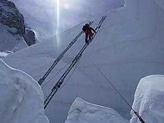
Ladders are used to pass the crevices in the Khumbu Icefall
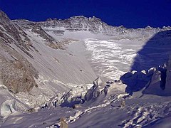
Valley of Silence and Lhotse Flank with the "Geneva Spur"


North route

The alternative to the south route is the north route from the Tibetan side. It begins in the Rongpu valley with a base camp at an altitude of around 5300 m and leads in a two-day trek with yak transport into the valley of the eastern Rongpu glacier, where the advanced base camp (ABC, advanced base camp ) is located at the foot of the north saddle wall. is located. Then the tour goes up the steep slope to the north saddle (North Col) with a height of about 7000 m , from where the exposed summit ridges (north ridge and northeast ridge) enable the further ascent over less inclined ridges (compared to the steeper south route). A serious strenuous and technical climbing obstacle is behind the last camp in about 8,300 m height on the upper ridge, the middle of the three rock steps (second step) with a foot height of about 8,610 m . The second step has a climbing height of about 40 meters, the last five meters are almost vertical. A ladder was attached here by a Chinese expedition in 1975. From there, the route, which mostly runs on the ridge, leads quite far and also over the snowfield at the summit, which is up to 50 degrees steep. On his solo ascent of Mount Everest, Reinhold Messner avoided the second step and chose a path through the Norton Couloir .
Direttissime
Two of the three main walls have already been climbed in an approximately direct fall line to the summit ( Direttissima ): in 1975 the southwest face and in 2004 the north face. On the east wall ( Kangshung wall ) there are two climbed routes, but they cannot be counted as Direttissime. The east wall or Kangshung Direttissima has thus far not been mastered. If you did this, you would have to climb one of the highest walls on earth - calculated from the foot to the summit - a steep rock that is more than 3500 meters high and prone to avalanches.
Aircraft on Everest
On April 3, 1933, Mount Everest was flown over by an airplane for the first time, a Westland PV-3 (registration number: G-ACAZ) and an accompanying Westland PV-6 (G-ACBR), both equipped with a Bristol Pegasus engine . Under the direction of Douglas Douglas-Hamilton , Lord Clydesdale and later 14th Duke of Hamilton, important knowledge about flights at high altitude was gathered during the flight with open biplanes, which contributed to the further development of the pressurized cabin .
On September 26, 1988, the French alpinist Jean Marc Boivin was the first person to paraglide from Mount Everest. At that time, paragliding was still in its infancy.
The French Didier Delsalle landed as the first person on the summit of Mount Everest on May 14th and 15th, 2005: with a specially prepared helicopter of the type Eurocopter AS 350 B-3 , with "hover landings", that is with almost full engine power , just put on so that you can start again immediately in the event of danger or gusts. He did not get out at the summit and could not take any loads there.
In 2007 Bear Grylls flew Mount Everest with a paramotor .
Documentaries and feature films (selection)
- Wings Over Everest - Oscar-winning short film with recordings of the first overflight. 1934
- Documentary film "Mount Everest" about the Swiss expedition in 1952
- National Geographic Video - Return to Mount Everest . 1984.
- Robert Markowitz: In icy heights - dying on Mount Everest . 1997
- Reinhold Messner, Peter Habeler: Mount Everest - death zone . 2002.
- National Geographic - Unique Everest . 2003.
- Barny Revill: Everest - Game with Death . Discovery Channel, 2006-2007
- Graeme Campbell: Everest - Race to Death . 2007
- Victor Grandits: Mount Everest - My friends cemetery . SWR, 2007.
- First on Everest Universe. ORF, 2010.
- Sherpas: The real heroes on Everest , SF
- Jennifer Peedom: Sherpa - Trouble on Everest . 2015
- Baltasar Kormákur: Everest . 2015
literature
- Anatoli Boukreev, G. Weston DeWalt: The summit - tragedy on Mount Everest . Wilhelm Heyne Verlag, Munich 1998, ISBN 3-453-15052-X .
- David Breashears, Audrey Salkeld: Mallory's Secret. What happened on Mount Everest? Steiger, Munich 2000, ISBN 3-89652-220-5 .
- Jochen Hemmleb, Larry A. Johnson, Eric R. Simonson: The Spirits of Mount Everest. Finding Mallory and Irvine; the report of the expedition that George Mallory found . Frederking & Thaler, Munich 2001, ISBN 3-89405-108-6 .
- Jochen Hemmleb: Everest. Goddess mother of the earth . AS Verlag & Buchkonzept, Zurich 2002, ISBN 3-905111-82-9 .
- Sir Edmund Hillary: He who dares wins . Frederking & Thaler, Munich 2004 (2nd edition), ISBN 3-89405-122-1 .
- Peter Meier-Hüsing: Where the snow lions dance - Maurice Wilson's forgotten Everest ascent . Piper, 2003, ISBN 3-89029-249-6 .
- Jon Krakauer: To icy heights. The drama on Mount Everest . Piper, 2000, ISBN 3-492-22970-0 (also as audio book on 9 CDs, ISBN 978-3-86974-064-5 )
- Reinhold Messner: Everest - expedition to the end point . National Geographic Paperback (March 2008), ISBN 3-89405-857-9 .
- Reinhold Messner: Survived - All 14 eight-thousanders . 8th edition. BLV Verlagsgesellschaft, ISBN 3-405-15788-9 .
- Reinhold Messner: Mount Everest: Summit storm without a mask. In: Geo-Magazin. No. 7/1978, pp. 26–48 (“Reinhold Messner and Peter Habeler's spectacular ascent of Everest”).
- Laxman Prasad Bhattarai (Editor-in-Chief): Mountaineering in Nepal - Facts & Figures. Government of Nepal, Ministry of Tourism & Civil Aviation, Tourism Industry Division, Kathmandu 2010, tourism.gov.np ( Memento from April 14, 2012 in the Internet Archive ) (PDF; 8.0 MB) pp. 5–83 (English) .
- Judy and Tashi Tenzing: In the shadow of Everest. The story of the Sherpa . Frederking & Thaler, Munich 2003, pp. 5-83; ISBN 3-89405-601-0 .
- Stephen Venables: Everest: The Story of Its Exploration. Frederking & Thaler, Munich 2007, ISBN 978-3-89405-544-8 .
- Göran Kropp, David Lagercrantz: Alone on Everest . Goldmann, Munich 1998, ISBN 3-442-15019-1 .
- Woodrow Wilson Sayre: Four against Everest: The story of the latest small expedition over the north flank. Albert Müller Verlag, Zurich 1965
- Friedrich Otten: The fight for the giant (youth book about the exploration of Mount Everest). Berlin 1924
Web links

- German-language information page with trekking routes and slide shows
- Information portal about Mt. Everest (English)
- QVTR panorama (fullscreen) from Mt. Everest
- National Geographic (English)
- Mount Everest at himalaya-info.org
- Over Mount Everest
- Documentary "Mount Everest" by Condor Films, year of production: 1952
- Everest 3D
- Mount Everest webcam (Italian)
- High resolution panorama by David Breashears
- Claire O'Neill: A 3.8 Billion-Pixel Tour Of Mount Everest . ( NPR ).
- Mount Everest on GeoFinder.ch
- List of Mount Everest climbers with the number of their ascents
- Video: Flight with motor glider on Mount Everest . German Aerospace Center 2014, made available by the Technical Information Library (TIB), doi : 10.5446 / 12743 .
- DLR animation: Virtual summit storm - Mount Everest in 3D May 13, 2011
Individual evidence
- ↑ The Qomolangma Biosphere Reserve on the UNESCO website.
- ↑ a b c d Mount Everest: Climate change thaws dead climbers free. In: Spektrum.de. Spektrum der Wissenschaft Verlagsgesellschaft, March 22, 2019, accessed on March 31, 2019 .
- ↑ Joseph Poindexter: Between heaven and earth. The 50 highest peaks. Könemann, Cologne 1999, ISBN 3-8290-3561-6 , p. 56.
- ^ Clements R. Markham: A Memoir on the Indian Surveys. 2nd Edition. WH Allen & Co., London 1878, p. 105, Text Archive - Internet Archive .
- ^ AS Waugh: Papers relating to the Himalaya and Mount Everest (A). In: Proceedings of the Royal Geographical Society of London. 1, 1857, pp. 345-347, digitized in the BHL.
- ^ GO Dyhrenfurth: To the third pole. Munich 1952, p. 27 ff.
- ↑ Sir George Everest never saw the mountain named after him.
- ^ GO Dyhrenfurth: To the third pole. Munich 1952, p. 28 f.
- ↑ a b M. P. Searle, RL Simpson, RD Law, RR Parrish, DJ Waters: The structural geometry, metamorphic and magmatic evolution of the Everest massif, High Himalaya of Nepal - South Tibet. In: Journal of the Geological Society. 160, 2003, pp. 345-366, doi: 10.1144 / 0016-764902-126 .
- ↑ a b c Paul M. Myrow, Nigel C. Hughes, Michael P. Searle, CM Fanning, S.-C. Peng, SK Parcha: Stratigraphic correlation of Cambrian-Ordovician deposits along the Himalaya: Implications for the age and nature of rocks in the Mount Everest region. In: GSA Bulletin. 120, 2009, pp. 323-332, doi: 10.1130 / B26384.1 .
- ↑ a b R. F. Weinberg: Himalayan leucogranites and migmatites: nature, timing and duration of anatexis. In: Journal of Metamorphic Geology. 34, 2016, pp. 821-843, doi: 10.1111 / jmg.12204 .
- ↑ Dario Visonà, Bruno Lombardo: Two-mica and tourmaline leucogranites from the Everest – Makalu region (Nepal – Tibet). Himalayan leucogranite genesis by isobaric heating? In: Lithos. 62, 2002, pp. 125-150, doi: 10.1016 / S0024-4937 (02) 00112-3 .
- ↑ Harutaka Sakai, Minoru Sawada, Yutaka Takigami, Yuji Orihashi, Tohru Danhara, Hideki Iwano, Yoshihiro Kuwahara, Qi Dong, Huawei Cai, Jianguo Li: Geology of the summit limestone of Mount Qomolangma (Everest) and cooling history of the Yellow Band under the Qomolangma detachment. In: Island Arc. 14, 2005, pp. 297-310, doi: 10.1111 / j.1440-1738.2005.00499.x .
- ^ Matthew J. Kohn: Himalayan Metamorphism and Its Tectonic Implications. In: Annual Review of Earth and Planetary Sciences. 42, 2014. pp. 381-419, doi: 10.1146 / annurev-earth-060313-055005 .
- ↑ Entire section, unless otherwise quoted, from Travis L. Corthouts, David R. Lageson, and Colin A. Shaw: Polyphase deformation, dynamic metamorphism, and metasomatism of Mount Everest's summit limestone, east central Himalaya, Nepal / Tibet. In: Lithosphere. 8, 2016, pp. 38-57, doi: 10.1130 / L473.1 (Open Access).
- ↑ Highest peak is shifted by quake. In: China Daily . June 16, 2015, accessed June 16, 2015.
- ^ A b John Ford Shroder, Jr .: Everest, Mount, mountain peak in the Himalayas of southern Asia, considered the highest mountain in the world. Publinet Switzerland, accessed December 24, 2007.
- ↑ Lawrence W. Swan: The Aeolian Biome. In: BioScience. 42, 1992, no. 4, pp. 262-270.
- ↑ Heribert Schöller: Lichen - history, biology, systematics, ecology, nature conservation and cultural significance. Schweizerbartsche Verlagbuchhandlung, Frankfurt am Main 1997, ISBN 3-7829-1151-2 , pp. 21-28.
- ↑ John Hunt: The Ascent of Everest. Hodder & Stoughton, 1953, chapter 14.
- ^ What happened to Mallory & Irvine - A Synopsis. In: jochenhemmleb.com. Retrieved March 3, 2015 .
- ↑ Joseph Poindexter: Between heaven and earth. The 50 highest peaks. Könemann, Cologne 1999. ISBN 3-8290-3561-6 , p. 56.
- ↑ GPS measurement from 1999.
- ↑ Mount Everest is now 86 centimeters higher. In: spiegel.de . December 8, 2020, accessed December 8, 2020 .
- ↑ Highest mountain - Mount Everest is higher than previously thought. In: srf.ch . December 8, 2020, accessed December 8, 2020 .
-
↑ Wikinews: Mount Everest 86 centimeters higher than previously assumed - News from January 9, 2021
- ↑ Wade Davis: Into the Silence. P. 79. In the original the quote is: We missed both Poles after having control of the sea for 300 years, and we certainly ought not to miss the exploration of the Mt. Everest group after being the premier power in India for 160 [... ] I for one would be glad to go in with 2 to 10 coolies, or even solo, so as to secure this little bit of exploration for Britain.
- ↑ a b D. Breashers, A. Salkeld: Mallory's secret.
- ↑ Joseph Poindexter: Between heaven and earth. The 50 highest peaks. Könemann, Cologne 1999, ISBN 3-8290-3561-6 , p. 58.
- ↑ Meier-Hüsing: Where the snow lions dance - Maurice Wilson's forgotten Everest ascent.
- ↑ a b Joseph Poindexter: Between heaven and earth. The 50 highest peaks. Könemann, Cologne 1999, ISBN 3-8290-3561-6 , p. 59.
- ↑ Steven Venables: Everest. The story of its discovery. Munich 2007, pp. 21 and 150.
- ↑ Steven Venables: Everest. The story of its discovery. Munich 2007, p. 77 f.
- ↑ Pioneer on Everest. In: NZZ. May 24, 2016.
- ↑ a b c d e Messner: All 14 eight-thousanders. Page 64.
- ↑ J. Hemmleb: Mount Everest crime scene: The Mallory case.
- ↑ a b c Joseph Poindexter: Between heaven and earth. The 50 highest peaks. Könemann, Cologne 1999, ISBN 3-8290-3561-6 , p. 60.
- ↑ Tenzing Norgay, James Ramsey Ullman: Man of Everest. 1955.
- ↑ 50 years of the Everest Lhotse expedition.
- ↑ Pioneer on Everest. In: NZZ. May 24, 2016.
- ↑ a b c d e f g 8000ers.com with statistics on Mount Everest.
- ↑ Christoph Gunkel: "They crawled up like ghosts". Report and photos of the expedition led by Woodrow Wilson Sayre (1919–2002) on one day on February 25, 2015 (accessed on February 25, 2015).
- ↑ a b c Illegal on Everest: A forbidden piece of Swiss mountain history. In: SRF1.ch. People and Horizons, June 29, 2014 (“political waves”, minute 16, political ice age, minute 26:45 ff.).
- ↑ SAYRE EXPEDITION CELEBRATES 40th REUNION. In: EverestNews.com. 2001.
- ↑ With rubber boots to Mount Everest. 10vor10 , May 7, 2018.
- ↑ The attempt to break out - How a Swiss wanted to illegally conquer Everest. The Alps (SAC), November 2014.
- ↑ a b Joseph Poindexter: Between heaven and earth. The 50 highest peaks. Könemann, Cologne 1999, ISBN 3-8290-3561-6 , p. 61.
- ↑ Book of Records.
- ^ Christian Stangl : Seven Summit Speed. ( Memento of May 17, 2008 in the Internet Archive ). In: skyrunning.at.
- ↑ Report on the ascent with video on Tagesschau.de. ( Memento of September 27, 2008 in the Internet Archive ).
- ^ Report on the closure of Mount Everest. (Tagesschau.de archive).
- ^ Report on the closure of Mount Everest in the spring of 2008. ( Memento of May 13, 2008 in the Internet Archive ).
- ^ Report on the seizure of means of communication. ( Memento from April 20, 2008 in the Internet Archive ).
- ↑ Breaking news: Mr Park climbs Everest SW face. ( Memento from May 23, 2009 in the Internet Archive ).
- ^ Nations Everest 8000ers.com, Eberhard Jurgalski (rosemon), April 25, 2017, accessed May 14, 2018. - 1st Austrian on May 23, 2010. 1st Austrian woman without oxygen on May 24, 2010.
- ↑ On top of Everest. On: vol.at. May 26, 2010.
- ^ Nations Everest 8000ers.com, Eberhard Jurgalski (rosemon), April 25, 2017, accessed May 14, 2018. - 1st Austrian on May 23, 2010. 1st Austrian woman without oxygen on May 24, 2010.
- ↑ Lindsay Griffin: Korean Everest Sea to Summit marred by tragedy thebmc.co.uk, The British Mountaineering Council, May 27, 2013, accessed on January 2, 2017.
- ↑ Rajan Pokhrel: At least killed in avalanche Everest 12 . In: The Himalayan. April 18, 2014; Avalanche disaster on Mount Everest. In: Deutsche Welle . April 18, 2014; Mount Everest - Avalanche kills twelve Sherpas. In: Frankfurter Allgemeine. (FAZ.NET), April 18, 2014; Jonah Goles: Everest Deaths - How Many Sherpas Have Been Killed? In: Outside Online. April 18, 2014; Search for missing climbers on Mount Everest stopped. In: time online. April 20, 2014.
- ↑ Earthquake on Mount Everest: Helicopters reach the devastated mountaineering base camp. Retrieved April 26, 2015 .
- ↑ Stephanie Geiger: The mountain is no longer calling. In: Frankfurter Allgemeine Zeitung. April 30, 2015.
- ↑ Rangdu's photo exhibit reveals truth about Hillary Step. My City on July 9, 2017, accessed December 24, 2019.
- ↑ Stephanie Geiger: Blind Austrian on Mount Everest. In: Frankfurter Allgemeine Zeitung online. May 21, 2017.
- ↑ A Chinese man with two leg amputations conquered Mount Everest. In: orf.at. May 14, 2018. Retrieved May 14, 2018.
- ↑ a b c Eberhard Jurgalski : Everest. In: 8000ers.com. Retrieved on November 26, 2010 (English, ascent statistics).
- ↑ Everest - "Playground of the world". In: Robert Lessmann : The small people who carry heavy loads. Vienna 2008, ISBN 978-3-85476-263-8 , p. 62; Government of Nepal, Ministry of Culture, Tourism and Civil Aviation: Nepal Tourism Statistics 2013. ( Memento from January 30, 2016 in the Internet Archive ) (PDF) pp. 66, 72.
- ↑ cf. on this complex of problems z. B .: Everest - "Playground of the world". In: Robert Lessmann: The small people who carry heavy loads. Vienna 2008, ISBN 978-3-85476-263-8 , pp. 61–65.
- ↑ a b Joseph Poindexter: Between heaven and earth. The 50 highest peaks. Könemann, Cologne 1999, ISBN 3-8290-3561-6 , p. 62.
- ↑ Nepal orders the cleansing of Mount Everest. Innovation Report, July 12, 2005 (online).
- ↑ Nepal says Everest climbers 'must collect 8kg litter'. In: BBC News. March 3, 2014, accessed April 18, 2014 .
- ↑ Japanese collects nine tons of waste on Everest. In: Spiegel online. May 29, 2007.
- ↑ Joanna Jolly: Everest 'death zone' to be cleaned up. In: BBC News. April 20, 2010, accessed May 22, 2012 .
- ↑ BBC.com: Everest clean-up campaign aims to airlift 100 tons of waste.
- ↑ Construction boom on Everest. In: Robert Lessmann : The small people who carry heavy loads. Vienna 2008, ISBN 978-3-85476-263-8 , pp. 71-73.
- ^ A b Paul G. Firth, Hui Zheng, Jeremy S. Windsor, Andrew I. Sutherland, Christopher H. Imray, GWK Moore, John L. Semple, Robert C. Roach, Richard A. Salisbury: Mortality on Mount Everest, 1921 –2006: descriptive study . doi : 10.1136 / bmj.a2654 ( abstract online [accessed on August 22, 2010]).
- ↑ Summit route opens as Kami Rita scales Everest 25 times In: The Himalayan Times. May 7, 2021.
- ↑ Saving Mount Everest. The highest mountain in the world is being cleaned up. ( Memento from January 3, 2018 in the Internet Archive ). In: primus.eu. o. J. (> = 2011), accessed on January 2, 2018.
- ↑ Doreen Fiedler: Malavath Poorna: With 13 years on Mount Everest. In: Westdeutsche Zeitung. June 15, 2014, online access .
- ↑ Japanese is the oldest woman on Mount Everest. In: Zeit Online . May 19, 2012.
- ↑ List of people who were more than 65 years old when they climbed 8000m. In: 8000ers.com.
- ↑ Stephanie Geiger: Nepalese dies before attempting to record. In: Frankfurter Allgemeine Zeitung . Retrieved May 8, 2017.
- ^ Alan Arnette: Everest by the Numbers: The Latest Summit Stats. In: alanarnette.com. Retrieved March 3, 2015.
- ↑ The gruesome sobering reality of death on Mt Everest. In: bbc.com. Retrieved May 24, 2016.
- ↑ Alan Arnette: Everest 2018: Welcome to Everest 2018 Coverage alanarnette.com, January 15, 2018.
- ↑ a b Joseph Poindexter: Between heaven and earth. The 50 highest peaks. Könemann, Cologne 1999, ISBN 3-8290-3561-6 , p. 64.
- ↑ Flight from Mount Everest - 30 years ago. In: Lu-Glidz-Blogspot.com. With video.
- ↑ Helicopter height record: Will there soon be a lift to Everest? In: Spiegel online. May 26, 2005.
- ^ Flying over the top of the world. In: BBC News. May 17, 2007 (English).
Africa: Kibo | Antarctica: Mount Vinson | Asia: Mount Everest | Australia / Oceania: Mount Kosciuszko • Puncak Jaya | Europe: Mont Blanc • Elbrus | North America: Denali | South America: Aconcagua