Greater Manchester
| Greater Manchester | |
|---|---|
| geography | |
| Status: |
Ceremonial County Metropolitan County |
| Region : | North West England |
| Area : | 1,276 km² |
| Demographics | |
| Population: | 2,812,569 ( 2018 ) |
| Population density : | 2,204 / km² |
| Metropolitan Boroughs | |
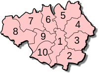
Greater Manchester is a metropolitan county in England and roughly covers the metropolitan area of Manchester . The county is located in the region of North West England and has 2.8 million inhabitants.
Greater Manchester is bordered by Cheshire , Derbyshire , West Yorkshire , Lancashire and Merseyside . It consists of ten metropolitan boroughs : Bolton , Bury , Manchester , Oldham , Rochdale , Salford , Stockport , Tameside , Trafford, and Wigan .
history
Before 1974, what is now Greater Manchester was divided between Cheshire and Lancashire . Smaller parts of the West Riding of Yorkshire and Derbyshire were also included. In the course of local government reform, the Metropolitan County Greater Manchester was formed, the administrative seat of which was in Manchester. The county government was abolished in 1986; since then, the metropolitan boroughs have performed their administrative tasks independently; Greater Manchester is still a ceremonial county .
towns and places
- Ainsworth , Altrincham , Ashton-in-Makerfield , Ashton-under-Lyne , Ashton-upon-Mersey , Astley Green , Atherton , Audenshaw
- Blackrod , Bolton , Boothstown , Bowdon , Bramhall , Broadbottom , Bury , Burnage
- Carrington , Chadderton , Cheadle , Cheadle Heath , Cheadle Hulme , Chorlton-cum-Hardy , Crumpsall
- Denton , Droylsden , Dukinfield
- Failsworth , Farnworth , Fallowfield , Flixton
- Gatley , Gorton
- Hazel Grove , Heald Green , Heywood , Horwich , Hyde
- Irlam
- Kearsley
- Leigh , Levenshulme , Littleborough , Little Lever , Lowton , Lowton Common
- Manchester , Marple , Marple Bridge , Mellor , Milnrow , Mossley , Mottram-in-Longdendale
- Northenden
- Oldham , Orrell , Openshaw
- Partington , Pendlebury , Pennington , Prestwich
- Radcliffe , Ramsbottom , Rochdale , Royton
- Sale , Salford , Shaw and Crompton , Standish , Stretford , Swinton
- Timperley , Trafford Park
- Urmston
- West Didsbury , Whitefield , Wigan , Withington , Woodley , Worsley , Westhoughton
Attractions
- Beetham / Hilton Tower
- Bolton Museum
- Bramall Hall
- Bury Art Gallery
- Bury Market
- Castlefield
- Chetham's School of Music, Manchester
- Curry Mile, Rusholme, Manchester
- Gallery of English Costume, Rusholme
- Salford Quays, Lowry Center and Imperial War Museum, North
- Salford Museum
- Wythenshawe Hall
- Astley Cheetham Art Gallery
- Museum of the Manchester Regiment, Ashton-under-Lyne
- Manchester Arndale Center
- Manchester Art Gallery
- Manchester Evening News Arena
- Manchester Museum
- Manchester Town Hall
- Manchester Central Library
- Manchester China Town
- Manchester Craft Village
- Manchester Northern Quarter
- Manchester Gay Village
- Manchester Spinningfields and People's History Museum
- Museum of Science and Industry , Manchester
- Imperial War Museum North , Manchester
- Ordsall Hall
- Park Bridge Heritage Center
- Portland Basin Museum
- Rochdale Town Hall
- Urbis
- Etherow Country Park
- Manchester Ship Canal
- East Lancashire Railway, a museum railway , Bury
- Whitworth Art Gallery , Manchester
- Heaton Park and Heaton Hall
- John Rylands Library, Deansgate
- Old Trafford
- Etihad Stadium
- City of Manchester Velodrome
- Hat Museum, Stockport
- Worsley Village
- Saddleworth and the surrounding area
- Trafford Center
Individual evidence
- ↑ Reevesn: Population Estimates for the UK, England and Wales, Scotland and Northern Ireland - Office for National Statistics. In: www.ons.gov.uk. Retrieved July 27, 2016 .
Coordinates: 53 ° 31 ′ N , 2 ° 16 ′ W


