
Fallowfield (Manchester)
| Fallowfield | |||
|---|---|---|---|
 |
|||
| Coordinates | 53 ° 27 ′ N , 2 ° 13 ′ W | ||
|
|||
| Residents | 14,132 (as of 2011) | ||
| administration | |||
| ZIP code section | M14 | ||
| prefix | 0161 | ||
| Part of the country | England | ||
| region | North West England | ||

Fallowfield is a district of Manchester , England , 3 miles south of the city center. The proportion of students in the population is very high, as the Fallowfield Campus and Owens Park (a high-rise) dormitories are located in this district .
history
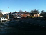
The first written mention comes from 1317 as Fallafeld (by the owner Jordan de Fallafield ). In 1530 there was the name Falowfelde . In 1891 the Fallowfield Station , the Fallowfield Train Station , was opened.
geography
Fallowfield is surrounded by Withington in the south, Whalley Range in the west, Levenshulme in the east and Rusholme in the north. In Fallowfield there is the publicly accessible Platt Fields Park .
Personalities
- Thomas Ashton (1855-1933), 1st Baron Ashton of Hyde
- Neil Young (1944-2011), football player
photos
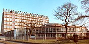
Fallowfield Campus of Manchester Metropolitan University

The Fallowfield Station building
The Yew Tree Road in Fallowfield


Web links
- Fallowfield, District of Manchester (English)