
Rusholme
| Rusholme | |||
|---|---|---|---|
 |
|||
| Coordinates | 53 ° 27 ′ N , 2 ° 13 ′ W | ||
|
|||
| Residents | 14,422 (as of 2011) | ||
| administration | |||
| ZIP code section | M14 | ||
| prefix | 0161 | ||
| Part of the country | England | ||
| region | North West England | ||

Rusholme is a district of Manchester , England , approximately 2 miles south of the city center. Because of its proximity to the universities, the population is largely made up of students.
The main thoroughfare is Wilmslow Road, with a variety of shops and restaurants, shaped by immigrants from India and Pakistan . In the south of Rusholme is the publicly accessible Platt Fields Park with a small lake.
history
The oldest finds are Roman gold coins from the second to third century AD, the name of a settlement Russum does not appear until the middle of the thirteenth century. Until the eighteenth century, the population depended on agriculture.
geography
Rusholme is surrounded by Fallowfield to the south, Moss Side to the west, Victoria Park to the east and Chorlton-on-Medlock to the north.
Personalities
- Neville Cardus , sports and music critic
- Roy Harper (* 1941), musician, singer-songwriter
- Alan Badel (1923–1982), actor
- Tina O'Brien , actress
- Ian Hay (real name John Hay Beith ), writer.
photos
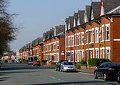
Platt Lane in Rusholme

View of Platt Fields Park
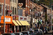
The Curry Mile of Wilmslow Road


Web links
- Rusholme, Suburb of Manchester (English)
- Historical about Rusholme (English)