
County Durham
| County Durham | |||
|---|---|---|---|
|
|||
|
|
|||
 _in_England.svg) |
|||
|
|
|||
| Country | United Kingdom | ||
| Part of the country | England | ||
| region | North East England | ||
|
|
|||
| status | Ceremonial county | ||
|
|
|||
| Ceremonial county | |||
| surface | 2,721 km² (18th of 48 ) | ||
| Residents | 862,600 | ||
| was standing | 2017 (estimate) | ||
|
|
|||
Districts / Unitary Authorities
|
|||


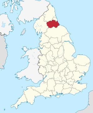
County Durham is a traditional and ceremonial county ( county ) in north east England .
About the name
The name of this county is a special case and in this form unique in England. Many counties are named for their capital city so one would expect the county to be called Durhamshire . However, it is called County Durham because the Bishop of Durham used to have sovereignty over areas that were outside the county. Therefore the inner part of his government area was named County Durham. (The naming County X is the normal form for the Irish counties and is not related to the specificity of County Durham).
geography
County Durham is bordered by the counties of Cumbria , Northumberland and Yorkshire , as well as Tyne and Wear . The eastern part of the county between the Ryhope district of the County Borough Sunderland and Hartlepool borders the North Sea . The administrative seat is Durham .
Geographically, County Durham is bounded by the watershed of the Pennines in the west, the River Tees in the south, the North Sea to the east and the River Tyne in the north. County Durham is bordered by traditional North Yorkshire counties .
administration
The administrative county was established in 1888. In the course of the 1974 territorial reform, the Metropolitan Boroughs Sunderland , South Tyneside and Gateshead were separated from County Durham and incorporated into the newly formed County Tyne and Wear . In addition, the borough , Stockton-on-Tees and the city of Hartlepool were incorporated into the also newly formed county of Cleveland . County Durham received the Startforth district south of the River Tees. Cleveland was later dissolved; Stockton and Hartlepool became independent city districts ( Unitary Authorities ).
In 1997, the city of Darlington, with over 100,000 residents, became a Unitary Authority and thus separated from County Durham. It has a joint police and fire department with the county.
On April 1, 2009, the seven districts of Derwentside , Chester-le-Street , City of Durham , Easington , Sedgefield , Wear Valley and Teesdale were abolished as part of an administrative reform and merged into the Unitary Authority County Durham . As a result, County Durham now has only a single administrative division into four unitary authorities.
towns and places
- Anfield Plain
- Barnard Castle
- Billingham
- Bishop Auckland
- Burnhope
- Catchgate
- Chester-le-Street
- Consett
- Craghead
- Darlington
- Durham
- Eaglescliffe
- Easington
- Everington
- Ferryhill
- Gainford
- Hartlepool
- Lanchester
- Newton Aycliffe
- No place
- Peterlee
- Sacristone
- Seaham
- Sedgefield
- Shotley Bridge
- Spennymoor
- Stanley
- Stockton-on-teas
- Tanfield
- Willington
Twin cities
At the suggestion of the British, there has been a partnership between County Durham and the university town of Tübingen since July 6, 1969.
Attractions
- Bowes Museum at Barnard Castle
- Durham Cathedral and Durham Castle, a World Heritage Site
- The High Force and Low Force Falls of the River Tees
- The Tansfield Railway in Tanfield
- North of England Open Air Museum in Stanley
Individual evidence
Bedfordshire | Berkshire | Buckinghamshire | Cambridgeshire | Cheshire | Cornwall | Cumberland | Derbyshire | Devon | Dorset | Durham | Essex | Gloucestershire | Hampshire | Herefordshire | Hertfordshire | Huntingdonshire | Kent | Lancashire | Leicestershire | Lincolnshire | Middlesex | Norfolk | Northamptonshire | Northumberland | Nottinghamshire | Oxfordshire | Rutland | Shropshire | Somerset | Staffordshire | Suffolk | Surrey | Sussex | Warwickshire | Westmorland | Wiltshire | Worcestershire | Yorkshire
Bedfordshire | Berkshire | Bristol | Buckinghamshire | Cambridgeshire | Cheshire | City of London | Cornwall | Cumbria | Derbyshire | Devon | Dorset | Durham | East Riding of Yorkshire | East Sussex | Essex | Gloucestershire | Greater London | Greater Manchester | Hampshire | Herefordshire | Hertfordshire | Isle of Wight | Kent | Lancashire | Leicestershire | Lincolnshire | Merseyside | Norfolk | North Yorkshire | Northamptonshire | Northumberland | Nottinghamshire | Oxfordshire | Rutland | Shropshire | Somerset | South Yorkshire | Staffordshire | Suffolk | Surrey | Tyne and Wear | Warwickshire | West Midlands | West Sussex | West Yorkshire | Wiltshire | Worcestershire
Coordinates: 54 ° 42 ′ N , 1 ° 51 ′ W