Stanage Edge
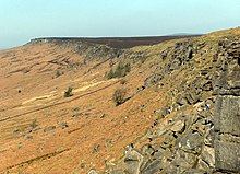
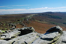
Stanage Edge , also shortened to Stanage (from English "Stone edge", German "Steinkante") is a sandstone part of the terrain in the Peak District National Park in northern England .
Geography and trivia

The northern part of the over 6 km long terrain formation is between High Peak in Derbyshire and Sheffield in South Yorkshire . The highest point is High Neb with 458 m ASL . In the 19th and early 20th centuries, millstones were made from stone from Stanage in certain areas . Millstones hewn on the slope, but never removed, can still be seen today.
A paved pack animal path ran along the upper edge of the terrain, remains of which can still be seen today. There are also remains of a Roman road that led through the demolition of Templeborough to Brough-on-Noe, crossed Hallam Moor and passed Stanedge Pole, an ancient landmark on the way to Sheffield. Some of the boundary marks along the contour line are even older. A well-known cave in the Stanage Edge cliff is known as Robin Hood's Cave .
Rock climbing
Stanage Edge is a popular destination for hikers , paragliders, and rock climbers in the Peak District. The edge of the land runs north from Cowper Stone to Stanage End. The northern cliffs are called Burbage Rocks, Froggatt Edge; Curbar Edge, Baslow Edge and Birden Edge. The southernmost point of Stanage Edge is a mighty block of sandstone called the Cowper Stone.
Although the edge of the terrain is only about 30 meters in elevation, it is one of the most popular hangouts for climbers in the UK. It offers a wealth of climbing routes. The challenging Right Unconquerable (HVS 5a) is also located at Stanage Edge, the first ascent of which by Joe Brown in 1949 is considered a milestone in British climbing. The 5 km long “Girdle Travers” is the longest climbing route in Great Britain. It was completely climbed for the first time in 1992 by the British climber Ron Fawcett and has the difficulty level "E5 6b (ish)" .
Others
- Stanage Edge was the film location of the Jane Austen novel Pride and Prejudice in 2005 . In one take, the leading actress Keira Knightley stands on a rock above the abyss of Stanage Edge.
- For the BBC production Jane Eyre in 2006 served Stanage also as a film location.
Web links
- Official Site of Stanage Edge (English)
Coordinates: 53 ° 21 ′ N , 1 ° 38 ′ W


