Ladybower Reservoir
| Ladybower Reservoir | |||||||
|---|---|---|---|---|---|---|---|
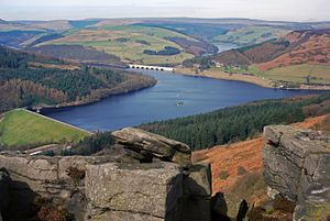
| The Ladybower Reservoir with the dam on the left and the Ashopton Viaduct in the background | |||||||
|
|||||||
|
|||||||
| Coordinates | 53 ° 23 ′ 0 ″ N , 1 ° 43 ′ 0 ″ W | ||||||
| Data on the structure | |||||||
| Construction time: | 1935-1943 | ||||||
| Height of the structure crown: | 43 m | ||||||
| Crown length: | 380 m | ||||||
| Data on the reservoir | |||||||
| Reservoir length | 4 km (maximum) | ||||||
| Reservoir width | 0.59 km (maximum) | ||||||
| Total storage space : | 27,896,000 m³ | ||||||
| The Derwent Valley Aqueduct at Ladybower Reservoir | |||||||
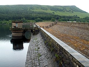
| Reservoir side of the Ladybower Reservoir dam | |||||||
The Ladybower Reservoir is a reservoir in the valley of the Derwent in Derbyshire , England . The reservoir is the third and last reservoir through which the Derwent flows after the Howden Reservoir and the Derwent Reservoir . The reservoir is shaped like the letter "Y" and was the largest reservoir in Britain at the time it was built.
history
The Ladybower Reservoir was built between 1935 and 1943 to meet the growing demand for drinking water, which the first two reservoirs could no longer meet.
With the filling of the reservoir, which lasted almost 2 years, the villages of Derwent and Ashopton sank in the water. The village of Ashopton was roughly where the Snake Valley and the road from Snake Pass meet the Derwent Valley to this day. The remains of the place are so deep that they can no longer be seen even at low tide. In contrast are the remains of the village of Derwent. A narrow stone bridge (a so-called Packhorse Bridge), which formerly crossed the River Derwent in the town of the same name, has been removed and rebuilt at the head of Howden Reservoir as part of the path around the reservoir. It is the only permanently visible remnant of the place that can still be seen in outline in the dam when the water is extremely low. The Derwent Dam Museum on Derwent Dam today commemorates the sunken villages.
The outbreak of war in 1939 hindered the construction work, as manpower and building materials were scarce, but construction was classified as essential to the war effort and continued at a slower pace.
The reservoir was on September 25, 1945 by King George VI. , who was accompanied by the later Queen Elizabeth II. , inaugurated.
The construction
Unlike the other two dams in the Derwent Valley, the dam of the Ladybower Reservoir consists of a wall filled with clay and clad with earth, which is secured on the side of the reservoir with a stone wall. To prevent water from leaking out of the lake, there is a ditch at the foot of the valley side of the dam, which extends 150 m wide into the mountain slopes on both sides and at a depth of 55 m and a width of 1.8 m Concrete is clad. The original dam was raised in the 1990s to prevent overflow in extreme flood situations.
What makes the Ladybower Reservoir are his two 24-meter-wide raid funnel near the dam which derive flood over 4.6 m wide outflows in normal circumstances.
The reinforced concrete Ashopton Viaduct leads the A57 from Glossop to Sheffield over the reservoir approximately at the point of the village Ashopton, and the Ladybower Viaduct , also made of reinforced concrete, leads the A6013 from the south end of the reservoir to the A57.
The Ladybower Reservoir is managed by Severn Trent Water and its water is diverted through the Derwent Valley Aqueduct for use as drinking water.
swell
- Vic Hallam, Silent Valley: The Story of the lost Derbyshire villages of Derwent and Ashopton , Sheffield, Sheaf Publishing, 1989. ISBN 09505458 9 9 .
Web links
- Severn Trent Water The current filling levels of the reservoir are published under the menu item "Reservoir Level".
- BBC Inside Out - Sunken Villages
- Derwent Dam Museum


