Snake Pass
| Snake Pass | |||
|---|---|---|---|
|
The road to Snake Pass from the west |
|||
| Compass direction | west | east | |
| Pass height | 512 m | ||
| county | Derbyshire | ||
| Watershed | River Etherow | River Ashop | |
| Valley locations | Glossop | Ashopton | |
| expansion | Pass road | ||
| Lock | winter | ||
| profile | |||
| Ø pitch | 5.2% (362 m / 7 km) | 2.2% (302 m / 14 km) | |
| Max. Incline | 8.1% (on km 5) | 8.2% (on km 14) | |
| Map (Derbyshire) | |||
|
|
|||
| Coordinates | 53 ° 25 '58 " N , 1 ° 52' 11" W | ||
Snake Pass is the name of a section of the A57 trunk road between Glossop and Sheffield in the Peak District in Derbyshire , England .
The road leads between the Kinder Scout and the Bleaklow of Glossop in the west with a gradient of up to 7% up to the pass at a height of 512 m above sea level . To the west the road slopes down to Ladybower Reservoir .
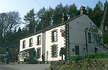
In 1820 the first road was built over Snake Pass as the shortest route from Manchester to Sheffield. The name of the pass comes from a pub , the "Snake Inn" , which is located on the western side of the pass and is now called the "Snake Pass Inn".
The Snake Pass was voted a particularly recommended route by a car magazine. The A57 is often closed during the Snake Pass in winter due to slippery ice and snow.
Others
Not only has the road been crossed by cyclists in the Tour of Britain cycle race, the Glossop Children's Velo Cycling Club regularly races over the pass.
The music group The Human League sang about the Snake Pass in their title "The Snake" on their album Secrets (2001).
The band Autechre refers to places on the Snake Pass with the titles of their album Anvil Vapre .
proof
- ↑ England's best driving road Autotrader Magazine April 23, 2009


