Włodowice (Nowa Ruda)
| Włodowice | ||
|---|---|---|
 Help on coat of arms |
|
|
| Basic data | ||
| State : | Poland | |
| Voivodeship : | Lower Silesia | |
| Powiat : | Kłodzko | |
| Gmina : | Nowa Ruda | |
| Geographic location : | 50 ° 34 ' N , 16 ° 28' E | |
| Height : | 400 m npm | |
| Residents : | ||
| Telephone code : | (+48) 74 | |
| License plate : | DKL | |
| Economy and Transport | ||
| Street : | Nowa Ruda - Kłodzko | |
| Next international airport : | Wroclaw | |
Włodowice (German Walditz ; Czech Valdice ) is a village in the rural municipality of Nowa Ruda in Poland . It is located three kilometers southwest of Nowa Ruda ( Neurode ) and belongs to the powiat Kłodzki . The border with the Czech Republic runs to the west .
geography
Włodowice belongs geographically to the Glatzer Kessel and lies on the river Włodzica ( Walditz ), which flows into the stones near Sarny ( Scharfeneck ) . The provincial road 385, which runs from the border crossing Tłumaczów / Otovice to Ząbkowice Śląskie, runs through the village . Neighboring towns are Sokolica and Grządka ( basic ) in the north, Bieganów , Zagorzyn ( Teuber ) and Bieganówek ( New Biehals ) to the southeast, Górzna ( Schoepp Mountain ) and Dwor Sarny ( Scharfeneck ) in the south, Błogocice ( Haindorf ) Tłumaczów, Tłumaczówek ( small Tuntschendorf ) and Rudawa ( Rudelsdorf ) in the southwest, Rzędzina ( Escape ) in the west and Rybno ( Fischerberg ) and Krajanówek ( Klein Kransdorf ) in the northwest. To the east of Włodowice rises the 647 m high Góra Św. Anny ( Annaberg ).
history
Walditz belonged to the Neuroder district in the county of Glatz , which until 1763 belonged directly to Bohemia . It was first mentioned in 1352 as "Waldicz" and was then owned by the Walditz family, whose ancestral seat is said to have been the Oberwalditz manor since 1258. It later came to the Stillfried on Neurode.
After the Hubertusburg Peace in 1763, Walditz fell to Prussia together with the County of Glatz . After the reorganization of Prussia, it belonged to the province of Silesia from 1815 , which was divided into districts. The district of Glatz was responsible from 1816–1853, and the district of Neurode from 1854–1932 . After its dissolution in 1933, it again belonged to the Glatz district until 1945. Since 1874, the rural community of Walditz, together with the rural communities of Krainsdorf and Zaughals and the manor districts of Krainsdorf, Nieder Walditz, Ober Walditz and Zaughals, belonged to the Krainsdorf district, which was later renamed the Walditz district .
There was an economic boom in 1862 when a mechanical cloth-making factory was built in Oberwalditz. The commissioning of the Waldenburg – Glatz railway at the beginning of the 1880s, when Neurode received a train station, also accelerated economic development. In addition, Walditz gained importance as a summer resort. In 1939 it consisted of 1198 inhabitants.
As a result of the Second World War , Walditz fell to Poland with most of Silesia in 1945 and was renamed Włodowice . Unless they had fled before, the German population was largely expelled in 1946. Some of the new residents were displaced from eastern Poland . 1975-1998 Włodowice belonged to the Wałbrzych Voivodeship (German: Waldenburg ).
Attractions
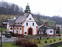
- The St. Canisius Church was built in 1929 in the neo- baroque style and provided with a roof turret.
literature
- Peter Güttler u. a .: The Glatzer country . Aktion West-Ost e. V., Düsseldorf 1995, ISBN 3-928508-03-2 , p. 113
Web links
Individual evidence
- ↑ Marek Šebela, Jiři Fišer: České Názvy hraničních Vrchů, Sídel a vodních toků v Kladsku . In: Kladský sborník 5, 2003, p. 370
- ^ Headquarters in Ober Walditz
- ^ Walditz district
- ↑ Cloth making

