
Rzepin
| Rzepin | |||
|---|---|---|---|

|
|
||
| Basic data | |||
| State : | Poland | ||
| Voivodeship : | Lebus | ||
| Powiat : | Slubice | ||
| Gmina : | Rzepin | ||
| Area : | 11.42 km² | ||
| Geographic location : | 52 ° 21 ' N , 14 ° 50' E | ||
| Height : | 69 m npm | ||
| Residents : | 6606 (December 31, 2016) | ||
| Postal code : | 69-110 | ||
| Telephone code : | (+48) 95 | ||
| License plate : | FSL | ||
| Economy and Transport | |||
| Street : | DK 2 ( Europastraße 30 ): ( Berlin -) Świecko - Warsaw - Terespol / Belarus | ||
| Ext. 134 : Muszkowo - Urad | |||
| Ext. 139 : Górzyca - Debrznica | |||
| Rail route : | Frankfurt (Oder) –Posen | ||
| Wroclaw-Szczecin | |||
| Next international airport : | Poznań-Ławica | ||
| Berlin Schoenefeld | |||

Rzepin ( German Reppen ) is a town in the powiat Słubicki of the Polish Lubusz Voivodeship . It is the seat of the town-and-country municipality of the same name with around 9850 inhabitants.
Geographical location
The city lies in the Neumark in the middle of the extensive forests of the Reppener Heide (Puszcza Rzepińska) on the river Ilanka ( Eilang ). The Berlin – Poznan motorway runs immediately to the south. The Rzepin station is railway junction of routes Wroclaw Szczecin and Frankfurt (Oder) -Posen . Frankfurt (Oder) is 20 kilometers away.

history
The place was created in the course of the Ascanian settlement in the east in the second half of the 13th century, favored by the Eilang crossing of the old trade route from Frankfurt to Posen . As early as 1329, the name city was used in a document. Since the Eilang marshland formed the surrounding area, no city wall was built, rather a triple rampart provided sufficient protection. The mercenary troops of Hans II of Sagan did not succeed in taking the city during the Glogische Feud in 1477. This attack was a sign of the neglect of the Neumark , the Brandenburg territory to which Reppen belonged. In the 16th and 17th centuries, the city shared the fate of many Neumark towns that were ravaged by the Thirty Years War and the plague epidemics.
Only with the creation of the Kingdom of Prussia did the situation in Reppen improve again. Through a settlement program by King Friedrich I , cloth makers immigrated, who developed the city into an important cloth-making center. Only the continental blockade imposed in the Napoleonic wars interrupted the economic boom at the beginning of the 19th century for a certain time.

Soviet war memorial

railway station

Disused steam locomotive
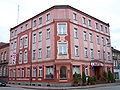
Hotel building

Main shopping street Reppen with the Protestant Katharinenkirche on a picture postcard from 1900

Gothic portal of the Katharinenkirche

City Hall
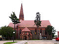
City Church (Protestant until 1945)

school-building

.JPG)


As a result of the Prussian administrative reorganization after the Congress of Vienna , Reppen was incorporated into the Sternberg district with the district town of Drossen in 1818 . After the division of the district, Reppen became the county seat of the Weststernberg district in 1904 . In 1869 it was connected to the Berlin – Posen railway line and in 1875 a railway junction was created through the Stettin – Glogau line. In 1890 the crossing point was expanded to include the branch line to Meseritz . Reppen was the administrative seat of the Weststernberger Kreiskleinbahn , which operated a route from the nearby Kunersdorf to Ziebingen .
Due to this favorable traffic situation, an industrial center developed, in which a potato starch factory, tanneries, shoemakers and steam mills were located next to the traditional cloth making. The number of inhabitants had more than doubled from around 2,000 to over 4,500 at the beginning of the 19th century.
1845 belonged to Reppen district Weststernberg in the administrative district of Frankfurt of the province of Brandenburg .
At the end of the Second World War , Reppen was badly damaged, but the two most important architectural monuments, the Katharinenkirche and the Herrenhof, were preserved. After the war ended, the city was placed under Polish administration. Polish migrants settled here, some of them from areas east of the Curzon Line , which Poland had conquered after the First World War . After 1945 the German city was called Rypin for a short time and then Rzepin . Insofar as the German residents had not fled, they were subsequently expelled by the local Polish administrative authorities .
Between 1945 and 1952 Rzepin was the seat of a Polish powiat .
On July 9, 1952, a troop transport derailed near Rzepin. The Soviet Army lost almost 200 officers and soldiers in this railway accident.
Population numbers
- 1719: 1.014
- 1740: 1.789
- 1750: 1.789
- 1801: 2.192
- 1840: 3.012
- 1855: 3,446, including 15 Catholics and 26 Jews
- 1875: 4.112
- 1880: 4.258
- 1925: 5,740
- 1933: 6.421
- 1939: 6,444

Population development
before and after 1945:
local community
The town itself and ten villages with school administration offices belong to the town-and-country community (gmina miejsko-wiejska) Rzepin. It covers an area of 191 km².
Personalities
- Georg Roenneberg (1834–1895), Berlin local politician
- Ernst Wenck (1865–1929), sculptor
- Geo A. Schmidt (1870–1943), colonial administrator
- Johannes Weigelt (1890–1948), paleontologist
- Johannes Wolburg (1905–1976), geologist and paleontologist
- Friedo Solter (* 1932), theater director.
- Lona Rietschel (1933–2017), graphic artist and comic artist.
literature
- Heinrich Berghaus : Land book of the Mark Brandenburg and the Margraviate Nieder-Lausitz in the middle of the 19th century . Volume 3, 1st edition, Brandenburg 1856, pp. 255-261 ( online ).
- W. Riehl, J. Scheu (Hrsg.): Berlin and the Mark Brandenburg with the Margraviate Nieder-Lausitz in their history and in their present existence . Berlin 1861, pp. 484-486.
- Eduard Ludwig Wedekind : Sternbergische Kreis-Chronik. History of the cities, towns, villages, colonies, castles etc. of this part of the country from the earliest past to the present . Zielenzig 1855, pp. 201-203.
- Heinz W. Linke: Rittergutsdörfer - Kohlow, Zerbow, Schmagorei, Lieben . Verlag BoD, Norderstedt 2013, ISBN 978-3-8482-6786-6 ( limited preview ).
Web links
Footnotes
- ↑ a b c d e f W. Riehl, J. Scheu (ed.): Berlin and the Mark Brandenburg with the Margraviate of Nieder-Lausitz in their history and in their current existence . Berlin 1861, pp. 484-486.
- ^ Reader's Digest Almanac and Yearbook. Readers' Digest Association, 1968, p. 732 ( online on Google Books ).
- ^ Eduard Ludwig Wedekind : Sternbergische Kreis-Chronik. History of the cities, towns, villages, colonies, castles etc. of this part of the country from the earliest past to the present . Zielenzig 1855, p. 202.
- ^ A b c d e Michael Rademacher: German administrative history from the unification of the empire in 1871 to the reunification in 1990. weststernberg.html. (Online material for the dissertation, Osnabrück 2006).