Droga krajowa 2
| Droga krajowa 2 in Poland | |||||||||||||||||||||||||||||||||||||||||||||||||||||||||||||||||||||||||||||||||||||||||||||||||||||||||||||||||||||||||||||||||||||||||||||||||||||||||||||||||||||||||||||||

|
|||||||||||||||||||||||||||||||||||||||||||||||||||||||||||||||||||||||||||||||||||||||||||||||||||||||||||||||||||||||||||||||||||||||||||||||||||||||||||||||||||||||||||||||
| |
|||||||||||||||||||||||||||||||||||||||||||||||||||||||||||||||||||||||||||||||||||||||||||||||||||||||||||||||||||||||||||||||||||||||||||||||||||||||||||||||||||||||||||||||
| map | |||||||||||||||||||||||||||||||||||||||||||||||||||||||||||||||||||||||||||||||||||||||||||||||||||||||||||||||||||||||||||||||||||||||||||||||||||||||||||||||||||||||||||||||
| Basic data | |||||||||||||||||||||||||||||||||||||||||||||||||||||||||||||||||||||||||||||||||||||||||||||||||||||||||||||||||||||||||||||||||||||||||||||||||||||||||||||||||||||||||||||||
| Operator: |
|
||||||||||||||||||||||||||||||||||||||||||||||||||||||||||||||||||||||||||||||||||||||||||||||||||||||||||||||||||||||||||||||||||||||||||||||||||||||||||||||||||||||||||||||
| Start of the street: |
Świecko ( 52 ° 19 ′ N , 14 ° 35 ′ E ) |
||||||||||||||||||||||||||||||||||||||||||||||||||||||||||||||||||||||||||||||||||||||||||||||||||||||||||||||||||||||||||||||||||||||||||||||||||||||||||||||||||||||||||||||
| End of street: |
Terespol ( 52 ° 4 ′ N , 23 ° 39 ′ E ) |
||||||||||||||||||||||||||||||||||||||||||||||||||||||||||||||||||||||||||||||||||||||||||||||||||||||||||||||||||||||||||||||||||||||||||||||||||||||||||||||||||||||||||||||
| Overall length: | 204 km | ||||||||||||||||||||||||||||||||||||||||||||||||||||||||||||||||||||||||||||||||||||||||||||||||||||||||||||||||||||||||||||||||||||||||||||||||||||||||||||||||||||||||||||||
| Development condition: | see below | ||||||||||||||||||||||||||||||||||||||||||||||||||||||||||||||||||||||||||||||||||||||||||||||||||||||||||||||||||||||||||||||||||||||||||||||||||||||||||||||||||||||||||||||
| DK2 as a bypass in Siedlce | |||||||||||||||||||||||||||||||||||||||||||||||||||||||||||||||||||||||||||||||||||||||||||||||||||||||||||||||||||||||||||||||||||||||||||||||||||||||||||||||||||||||||||||||
|
Course of the road
|
|||||||||||||||||||||||||||||||||||||||||||||||||||||||||||||||||||||||||||||||||||||||||||||||||||||||||||||||||||||||||||||||||||||||||||||||||||||||||||||||||||||||||||||||
The National Road 2 (short DK2 , pol. On National Road 2 'or, country road 2') is a country road in Poland . It currently leads on two sections from Świecko to the Belarusian border and represents an important east-west axis in Polish road traffic . The total length is 186.5 kilometers. The first section from the Świecko - Frankfurt border crossing to the Świecko junction is 3 kilometers, the second from Warsaw to Choszczówka Stojecka near Mińsk Mazowiecki is 45.5 kilometers, the third from Kałuszyn to the Belarusian border in Terespol is 141 kilometers long. In its original route as a continuous west-east axis, it has now been replaced on some sections by the A2 motorway and the S2 expressway . After the completion of the A2 motorway and the S2 expressway, the state road will disappear from the road network.
meaning
The state road is of great international importance in terms of traffic engineering: It is part of the II. Pan-European traffic corridor, part of the important traffic route from Western Europe to the successor states of the Soviet Union and is accompanied on its entire route by European route 30 .
history
The western branch of DK2 was formed by the German Reichsstrasse 167 , 97 and 114 until 1945 , with Reichsstrasse 114 also continuing in the annexed Reichsgau Wartheland towards Warsaw.
Landesstrasse 2 was established in 1986 and was the most important east-west connection in Poland. The section east of Warsaw was referred to as Droga państwowa 4 until 1985 , while the section west of Warsaw was called Droga państwowa 17 , part of the former E8 road.
The road between Warsaw and Brest was built between 1814 and 1826 and was expanded into an avenue early on as a supply route for the Russian army.
With the completion of the sections of the A2 motorway that run parallel to Landesstraße 2, the route from the Landesstraße to Landesstraße 92 was rededicated as an alternative to the toll motorway. This already happened in 2003 between Września and Konin , in 2005 between Miedzichowo , Posen and Września, in 2008 between Konin, Kutno and Łowicz , in 2011 between Rzepin and Miedzichowo, in 2012 between Łowicz and Warsaw and in the same year between Mińsk Mazowiecki and Kałuszyn .
Traffic safety
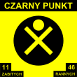
The road has several so-called black points (Polish: czarne punkty ; singular czarny dot ). These are places at which accidents occur particularly frequently. On September 7, 1998, the first Polish sign was erected near Błonie . They are now between Świebodzin and Wityń , in Sławacinek Nowy , Brzeźno , Nekla and Buczyce . As early as 2003, no new signs were put up due to a lack of driver attention. In contrast to this, the Drogi Zaufania (German: "Trust streets") program was developed by the GDDKiA . As part of this program, various traffic safety measures were taken from 2008 onwards at places with an increased risk of accidents along the state road. For example, new intersections with traffic lights have been built to slow down traffic, new pedestrian crossings have been built and sidewalks have been added.
State of development
The development of state road 2 is structured as follows:
| section | Stripes | Dividing strip | comment |
|---|---|---|---|
| Świecko border crossing - Świecko junction | 4th | Yes | |
| Warsaw metropolitan area | 4th | No | urban |
| Warsaw - Mińsk Mazowiecki |
2 | No | |
|
|
2 | No |
Important places along the route
- Świecko
- Warsaw
- Mińsk Mazowiecki
- Kałuszyn
- Siedlce
- Międzyrzec Podlaski
- Biała Podlaska
- Wólka Dobryńska
- Terespol
See also
Web links
- GDDKiA website (Polish)
- Website of the Drogi Zaufania program (Polish)
Footnotes
- ↑ Route of national road 2 from Warsaw to Mińsk Mazowiecki on maps.google.de (accessed on August 13, 2013)
- ↑ Route of state road 2 from Kałuszyn to the Belarusian border on maps.google.de (accessed on August 13, 2013)
- ^ The German Automobile Club (ed.): Road map of Germany, scale 1: 1,250,000, 1941
- ^ Ordinance of the Ministry of Construction of August 26, 1949 on the minimum distance between buildings on some main roads. Dz.U. 1949 no. 52 poz. 398
- ↑ Annals of geography, ethnology and national studies. Born in 1830, p. 785.
- ↑ Krajowej Rady Bezpieczeństwa Ruchu Drogowego, Czarne punkty ( Memento from December 30, 2013 in the Internet Archive ) (PDF file; 925 kB; Polish)
- ↑ Drogi w programie: Droga krajowa nr 2 ( Memento from June 3, 2013 in the Internet Archive ) (Polish)


