Droga krajowa 1
| Droga krajowa 1 in Poland | ||||||||||||||||||||||||||||||||||||||||||||||||||||||||||||||||||||||||||||||||||||||||||||||||||||||||||||||||||||||||||||||||||||||||||||||||||||||||||||||||||||||||||||||||||||||||||||||||||||||||||||||||||||||||||||

|
||||||||||||||||||||||||||||||||||||||||||||||||||||||||||||||||||||||||||||||||||||||||||||||||||||||||||||||||||||||||||||||||||||||||||||||||||||||||||||||||||||||||||||||||||||||||||||||||||||||||||||||||||||||||||||
| |
||||||||||||||||||||||||||||||||||||||||||||||||||||||||||||||||||||||||||||||||||||||||||||||||||||||||||||||||||||||||||||||||||||||||||||||||||||||||||||||||||||||||||||||||||||||||||||||||||||||||||||||||||||||||||||
| map | ||||||||||||||||||||||||||||||||||||||||||||||||||||||||||||||||||||||||||||||||||||||||||||||||||||||||||||||||||||||||||||||||||||||||||||||||||||||||||||||||||||||||||||||||||||||||||||||||||||||||||||||||||||||||||||
| Basic data | ||||||||||||||||||||||||||||||||||||||||||||||||||||||||||||||||||||||||||||||||||||||||||||||||||||||||||||||||||||||||||||||||||||||||||||||||||||||||||||||||||||||||||||||||||||||||||||||||||||||||||||||||||||||||||||
| Operator: |
|
|||||||||||||||||||||||||||||||||||||||||||||||||||||||||||||||||||||||||||||||||||||||||||||||||||||||||||||||||||||||||||||||||||||||||||||||||||||||||||||||||||||||||||||||||||||||||||||||||||||||||||||||||||||||||||
| Start of the street: |
Piotrków Trybunalski ( 51 ° 24 ′ N , 19 ° 38 ′ E ) |
|||||||||||||||||||||||||||||||||||||||||||||||||||||||||||||||||||||||||||||||||||||||||||||||||||||||||||||||||||||||||||||||||||||||||||||||||||||||||||||||||||||||||||||||||||||||||||||||||||||||||||||||||||||||||||
| End of street: |
Milówka ( 49 ° 34 ′ N , 19 ° 5 ′ E ) |
|||||||||||||||||||||||||||||||||||||||||||||||||||||||||||||||||||||||||||||||||||||||||||||||||||||||||||||||||||||||||||||||||||||||||||||||||||||||||||||||||||||||||||||||||||||||||||||||||||||||||||||||||||||||||||
| Overall length: | 180.3 km | |||||||||||||||||||||||||||||||||||||||||||||||||||||||||||||||||||||||||||||||||||||||||||||||||||||||||||||||||||||||||||||||||||||||||||||||||||||||||||||||||||||||||||||||||||||||||||||||||||||||||||||||||||||||||||
| Development condition: | see below | |||||||||||||||||||||||||||||||||||||||||||||||||||||||||||||||||||||||||||||||||||||||||||||||||||||||||||||||||||||||||||||||||||||||||||||||||||||||||||||||||||||||||||||||||||||||||||||||||||||||||||||||||||||||||||
| DK1 in Częstochowa | ||||||||||||||||||||||||||||||||||||||||||||||||||||||||||||||||||||||||||||||||||||||||||||||||||||||||||||||||||||||||||||||||||||||||||||||||||||||||||||||||||||||||||||||||||||||||||||||||||||||||||||||||||||||||||||
|
Course of the road
|
||||||||||||||||||||||||||||||||||||||||||||||||||||||||||||||||||||||||||||||||||||||||||||||||||||||||||||||||||||||||||||||||||||||||||||||||||||||||||||||||||||||||||||||||||||||||||||||||||||||||||||||||||||||||||||
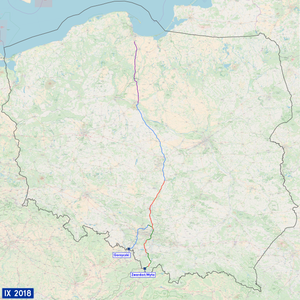
The National Road 1 (short DK1 , pol. On National Road 1 'or' country road 1 ') is a country road in Poland . It currently leads from Piotrków Trybunalski to the Slovakian border near Zwardoń and represents an important north-south axis in Polish road traffic . The total length is 180.3 kilometers. The first section from Piotrków Trybunalski to Dąbrowa Górnicza is 132 km, the second from Tychy to Bielsko-Biała 37.2 km and the third from Przybędza to Milówka 11.1 km. In the meantime it has been replaced on some sections by the A1 motorway and the S1 expressway . After the completion of the A1 motorway and the S1 expressway, the state road will disappear from the road network.
meaning
The state road is of great importance both nationally and internationally: On the one hand, it is part of the 5th pan-European traffic corridor and is accompanied on its entire route by the European route 75 , between the border with the Czech Republic and the Mysłowice junction (A4 motorway) is part of the European route 462 . On the other hand, due to its expressway-like expansion between the Czech border and Łódź, it is an important national transit route from the industrial areas of Silesia to the metropolitan regions of Łódź and Warsaw as well as to the seaports in Gdansk and Gdynia .
history
With the reform of the numbering of all state roads , the route of the state road was determined on May 9, 2001. Even before 2001, some of today's sections were designated and signposted as Landesstraße 1. During the time of the People's Republic of Poland , today's four-lane sections from Piotrków Trybunalski via Częstochowa to Podwarpie as part of the so-called Gierkówka and from Podwarpie via Dąbrowa Górnicza to Tychy as part of the eastern bypass of the Upper Silesian industrial area were completed and designated as state road 1.
The planning of the section from Piotrków Trybunalski via Częstochowa to Podwarpie was started in 1972. They stipulated that the new road should bypass all localities and be expanded like a motorway. The road cross-section should consist of two lanes, each with two lanes. Due to the decision to build junctions instead of elevation-free junctions , the road was not designated as a motorway. At the end of the 1980s, the entire route was opened. The old, parallel route was rededicated as Landesstraße 91 in 2001 .
With the completion of the sections of the A1 motorway that run parallel to Landesstraße 1, the route from the Landesstraße to Landesstraße 91 was rededicated as an alternative to the toll motorway. This already happened completely between Gdansk and Toruń in 2011 and between Kowal and the Łódź-Północ junction in 2012 . In 2007, the section between Bielsko-Biała and Cieszyn was downgraded to municipal roads, as sections of state roads running parallel to expressways were not given an alternative.
Traffic safety
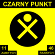
The road has several so-called black points (Polish: czarne punkty ; singular czarny dot ). These are places at which accidents occur particularly frequently. You are near Otłoczyn , Bielsko-Biała , between Bogusławice and Grabowa, between Łódź and Piotrków Trybunalski , near Podwarpie, Brudzowice, Dolna and Górna Grupa and Łęgowo. The black dots were set up in 1998. As early as 2003, no new signs were set up due to a lack of driver attention. In contrast to this, the Drogi Zaufania (German: "Trust streets") program was developed by the GDDKiA . As part of this program, various traffic safety measures were taken from 2008 onwards at places with an increased risk of accidents along the state road. For example, new intersections with traffic lights and new pedestrian crossings have been set up.
Sections in the modernization
Tychy county-level city
Within city limits of Tychy a 5,6 kilometer section of national road 1 is between the node Tychy and Tychy-Tychy as well as a 1.2 kilometer section of national road 86 modernized by the northern border to the node Tychy. The objectives of this project are to improve traffic flow, increase capacity, reduce travel time, improve the safety of vehicle and pedestrian traffic, separate local and transit traffic, and reduce the negative impact on the environment and residents. These goals should include a. can be achieved through the construction of three underground pedestrian tunnels, the construction of noise barriers along the national roads and the conversion of the intersection with Niepodległości avenue into a node. In addition, the roadways are to be renewed.
The construction contract between the city of Tychy and the construction company Polimex-Mostostal SA was signed on August 31, 2011. Construction began in December 2011. Completion was planned for the end of 2013. Due to construction delays, it was not completed until 2014. The construction costs were set at 150 million zlotys . The total cost of the investment is 189 million zloty, of which 85% (157 million zloty) will be borne by the European Union and 32 million zloty by the city.
State of development
The development of state road 1 is structured as follows:
| section | Stripes | Dividing strip | comment |
|---|---|---|---|
|
|
4th | Yes | |
|
|
4th | Yes | |
|
|
2 | No |
Important places along the route
- Piotrków Trybunalski
- Kamieńsk
- Radomsko
- Czestochowa
- Koziegłowy
- Siewierz
- Dąbrowa Górnicza
- Sosnowiec
- Jaworzno
- Mysłowice
- Tychy
- Pszczyna
- Czechowice-Dziedzice
- Bielsko-Biała
- Żywiec
See also
Web links
- GDDKiA website (Polish)
- Website of the Drogi Zaufania program (Polish)
- Website for the modernization of the section in Tychy (Polish)
Footnotes
- ↑ Route of national road 1 from Piotrków Trybunalski to Dąbrowa Górnicza on maps.google.de (accessed on August 21, 2016)
- ↑ Route of Landesstraße 1 from Tychy to Bielsko-Biała on maps.google.de (accessed on August 21, 2016)
- ↑ Route of state road 1 from Przybędza to Milówka on maps.google.de (accessed on August 21, 2016)
- ↑ Route of state road 1 from Łódź-Północ to Tuszyn on maps.google.de (accessed on August 13, 2013)
- ↑ Route of national road 1 from Piotrków Trybunalski to Dąbrowa Górnicza on maps.google.de (accessed on August 13, 2013)
- ↑ Route of Landesstrasse 1 from Tychy to Bielsko-Biała on maps.google.de (accessed on August 13, 2013)
- ↑ Krajowej Rady Bezpieczeństwa Ruchu Drogowego, Czarne punkty ( Memento from December 30, 2013 in the Internet Archive ) (PDF file; 925 kB; Polish)
- ↑ Drogi w programie: Droga krajowa nr 1 ( Memento from June 3, 2013 in the Internet Archive ) (Polish)
- ↑ a b Przebudowa DK nr 1 i 86 - Gdańsk - Cieszyn w granicach miasta Tychy: O projekcie ( Memento from January 17, 2014 in the Internet Archive ) (Polish)
- ↑ Przebudowa DK 1 w Tychach pełną parą ruszy wiosną 2012 (Polish; accessed on July 31, 2013)
- ↑ Wykonawca chce przedłużyć przebudowę drogi nr 1 w Tychach o pół roku (Polish)


