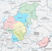
Powiat Będziński
| Powiat Będziński | |
|---|---|

|

|
| Basic data | |
| State : | Poland |
| Voivodeship : | Silesia |
| County town : | Będzin |
| Area : | 368.02 km 2 |
| Residents : | 148,516 (June 30, 2019) |
| Population density : | 404 inhabitants / km 2 |
| Degree of urbanization : | 75.99% |
| Telephone code : | (+48) 32 |
| License plate : |
SBE
|
| Circle structure | |
| Municipalities : | 4th |
| Urban and rural communities : | 1 |
| Rural communities : | 3 |
| Starostei (Stand:) | |
| Starost : | Bożena Respondek |
| Address: | ul. Sączewskiego 6 42-500 Będzin |
| Website : | www.starostwo.bedzin.pl |
The powiat Będziński is a powiat ( district ) in the Polish Silesian Voivodeship . The district is located in the Dombrowaer coal basin , the Lesser Poland part of the Upper Silesian coal mining area and has an area of 367 km² with 150,000 inhabitants.
history
Today's powiat has existed since January 1, 1999, but has a long tradition. This administrative district was detached from the powiat Olkuski by legal order in 1866 after the January uprising was put down and belonged to the newly formed Petrikau governorate . At that time it consisted of a township (Będzin) and 18 rural parishes, and it was located in an area that consisted of 213 villages after 8 towns were deprived of town charter. This oldest administrative district was the largest in the entire history of the district, after minor corrections in 1890 it covered 1,390.6 km² and had over 800,000 inhabitants. It was one of the more industrialized regions on the edge of the Russian Empire and bordered the Powiat Częstochowski in the north, the Oszczowski and Olkusz districts in the east, the Chrzanów district in the Austrian Empire in the south and the Prussian Kingdom in the west .
The second half of the 19th century was a stroke of luck for Będzin, because the District Office (now the District Court) was established there. This rapid development was interrupted by the First World War, the entire basin was divided into a German and an Austrian occupation zone during the war. In the re-established Republic of Poland , the extensive administrative district of Będzin in the Kielce Voivodeship no longer had a right to live and was instead divided between the three Powiats Będziński, Powiat Zawierciański and Powiat Myszkowski .
This administrative district comprised four cities in the center of the Basin d. H. Będzin, Czeladź , Dąbrowa Górnicza and Sosnowiec , which became independent in 1928. The area of the district covered 485 km² in 1928 and had almost 360 thousand inhabitants. By 1939 the municipalities of Bobrowniki , Grodziec , Łagisza , Ożarowice , Zagórze, Olkusko - Siewierska (Strzemieszyce Wielkie), Niwka, Łosień and Wojkowice Kościelne were incorporated. In the time of the Sanacja there were controversial plans to incorporate the powiat in the Silesian Voivodeship .
The boundaries of the administrative districts were not changed during the Nazi occupation, but the powiat was renamed the Bendsburg district and assigned to the Katowice district . Its district boundaries were retained after the war, but the powiat was attached to the newly formed Katowice Voivodeship . In 1948 the city of Będzin was also elevated to a district. During this time, the district was reduced to 360 km², especially in favor of the city of Dąbrowa Górnicza.
The powiat consisted of 9 cities, 1 settlement and 14 groups in 1975. In the course of the administrative reform of 1975, the district was dissolved, but Będzin remained a center, especially for the communities in the north of the city. Most of the authorities were concentrated in so-called regions, the area of which often included the old district boundaries. The powiat, rebuilt in 1999, received completely new district boundaries, it lost the historical areas around Ożarowice in favor of the Upper Silesian powiat Tarnogórski , but included the nearby town of Siewierz .
cities and communes
The powiat comprises five urban communities ( gmina miejska ) and three rural communities ( gmina wiejska ):
Boroughs
Rural communities
Web links
Footnotes
- ↑ population. Size and Structure by Territorial Division. As of June 30, 2019. Główny Urząd Statystyczny (GUS) (PDF files; 0.99 MiB), accessed December 24, 2019 .
- ^ Dariusz Majchrzak: Śląska autonomia dla Zagłębia Dąbrowskiego? Sprawa włączenia Zagłębia Dąbrowskiego do województwa śląskiego w II RP (Polish)


