Kielce Voivodeship (1919–1939)
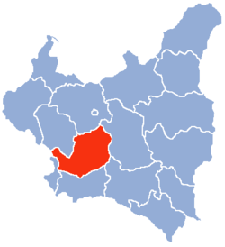
The Kielce Voivodeship ( Polish : województwo kieleckie ) was a voivodeship of the Second Polish Republic from 1919 to 1939 . The seat of the administration was in Kielce .
location and size
In 1921 the voivodeship covered an area of 25,741 km². The 39 cities and 310 rural communities were divided into 17 powiats .
The voivodeship with the cities of Radom , Częstochowa and Sosnowiec extended over a large part of central Poland. Due to the change in the allocation of various districts, the borders of the voivodeship changed on April 1, 1938.
At the beginning of 1939 the voivodeship covered an area of 22,204 km² and was located in the center of Poland. It bordered the German Empire in the west , albeit only with a narrow strip, and the Autonomous Voivodeship of Silesia , in the north on the Voivodeships of Łódź and Warsaw , in the east on the Voivodeships of Lublin and Lwów and in the south on the Voivodeship Krakow .
In the northern part the landscape was flat, in the middle with the Kielcer mountainous area and in the south it was hilly. According to the statistics of January 1, 1937, 21.2% of the land area was covered with forest, only slightly less than the 22.2% national average.
population
In 1921 there were 2,535,781 inhabitants in the voivodeship, of whom 2,314,232 were Polish, 215,360 Jewish, 3,655 German and 2,497 of other nationalities, apart from 2,220,902 Roman Catholics there were 300,489 people of the Jewish religion, 10,307 evangelicals and 3,844 of other faiths (mostly Orthodox ). According to the statistical data for 1931, there were about 2,671,000 inhabitants, of which 88.9% were of Polish origin and 10.7% were Jews. Most of the Jews lived in larger cities and towns, where they made up 28.7% of the total urban population of the voivodeship. There were around 7,900 Germans, over 95% of whom lived in the country, mostly in the Powiats Kozienicki, Częstochowski and Kielecki. In 1931, 25.7% of the population could not read or write, slightly more than the 23.1% of the national average.
economy
The voivodeship was industrially differently developed. The towns to the west such as Częstochowa, Sosnowiec or Będzin (see Zagłębie Dąbrowskie , Polish Coal Basin - the Zawiercie district was spun off there in 1927) offered numerous jobs, were the focus of coal mining, and were highly industrialized and well developed. Radom in the north was also considered an industrial center. The eastern areas, on the other hand, were backward, only slightly industrialized and agriculture was also considered to be barely developed.
In the mid-1930s, the government launched a state economic development program under the title Centralny Okręg Przemysłowy ("Central Industrial Region "), which particularly benefited the overpopulated and impoverished districts in the middle and east of the voivodeship.
Cities and administrative divisions
From April 1, 1938 to September 1, 1939, the following 18 powiats belonged to the territory of the voivodeship:
- Będzin district (area 459 km², inhabitants: 231 300),
- District of Częstochowa (area 1 855 km², inhabitants: 182 600),
- City district of Częstochowa (powiat częstochowski grodzki), (area 48 km², inhabitants: 117 200),
- Iłża district (area 1,835 km², inhabitants: 162,400),
- Jędrzejów district (area 1 277 km², inhabitants: 108 800),
- District of Kielce (area 2 052 km², inhabitants: 244 100),
- Kozienice district (area 1,857 km², inhabitants: 143,100),
- Miechów district (area 1,353 km², inhabitants: 153,700),
- District of Olkusz (area 1,361 km², inhabitants: 151,300),
- Opatów district (area 1,639 km², inhabitants: 186,500),
- Pińczów district (area 1,148 km², population: 126,000),
- Radom district (area 2 095 km², inhabitants: 166 900),
- Radom district (powiat radomski grodzki) (area 25 km², inhabitants: 77 900),
- Sandomierz district (area 1,186 km², inhabitants 124,400),
- Sosnowiec urban district (powiat sosnowiecki grodzki) (area 33 km², inhabitants: 109,000),
- Stopnica district (area 1 590 km², inhabitants: 153 200),
- Włoszczowa district (area 1,446 km², inhabitants: 101,600),
- Zawiercie district (area 945 km², population: 131,000).
According to statistics from 1931, the following were the largest cities in Kielce Voivodeship:
- Częstochowa (residents: 117 200),
- Sosnowiec (residents: 109,000),
- Radom (residents: 77 900),
- Kielce (residents: 58 200),
- Będzin (residents: 47 600),
- Dąbrowa Górnicza (residents: 36 900),
- Zawiercie (residents: 32,900),
- Ostrowiec Świętokrzyski (inhabitants: 25,900).
Voivodes
The following people ruled the voivodeship from 1919 to 1939:
- Stanisław Franciszek Pękosławski: November 19, 1919 - May 31, 1923
- Adam Kroebl: July 1, 1923 - August 31, 1923 (substitute)
- Mieczysław Bilski: September 1, 1923 - May 6, 1924
- Ignacy Manteuffel: May 24, 1924 - August 17, 1927
- Adam Kroebl: August 20, 1927 - October 20, 1927 (deputy)
- Władysław Korsak: October 21, 1927 - February 28, 1930
- Jerzy Paciorkowski: February 18, 1930 - May 15, 1934
- Stanisław Jarecki: May 17, 1934 - July 9, 1934 (substitute)
- Władysław Dziadosz: July 9, 1934 - September 1939
Individual evidence
- ↑ Archived copy ( memento of the original from October 29, 2008 in the Internet Archive ) Info: The archive link was inserted automatically and has not yet been checked. Please check the original and archive link according to the instructions and then remove this notice.
- ↑ Główny Urząd Statystyczny: Skorowidz miejscowości Rzeczypospolitej Polskiej. Tom III. Województwo kieleckie . Warszawa 1925, p. VIII [PDF: 5] (Polish, online [PDF]).
- ↑ Izabela Bożyk: Osadnictwo niemieckie na terenach wiejskich między Pilicą a Wisłą w latch 1815–1865 . Wydawnictwo MARRON, Kielce – Łódź 2015, ISBN 978-83-64637-80-3 , p. 269 (Polish).


