
Gmina Ożarowice
| Gmina Ożarowice | |||
|---|---|---|---|

|
|
||
| Basic data | |||
| State : | Poland | ||
| Voivodeship : | Silesia | ||
| Powiat : | Tarnogórski | ||
| Geographic location : | 50 ° 28 ' N , 19 ° 3' E | ||
| Residents : | see Gmina | ||
| Postal code : | 42-625 | ||
| Telephone code : | (+48) 032 | ||
| License plate : | STA | ||
| Economy and Transport | |||
| Next international airport : | Katowice | ||
| Gmina | |||
| Gminatype: | Rural community | ||
| Gmina structure: | 7 school offices | ||
| Residents: | 5794 (Jun. 30, 2019) |
||
| Community number ( GUS ): | 2413062 | ||
| Administration (as of 2008) | |||
| Community leader : | Grzegorz Czapla | ||
| Address: | ul.Dworcowa 15 42-625 Ożarowice |
||
| Website : | www.ozarowice.pl | ||

The Gmina Ożarowice is a rural community ( gmina wiejska ) in the powiat Tarnogórski in the Silesian Voivodeship in Poland . Its administrative headquarters are in the village of Ożarowice .
geography
Ożarowice is located on the northern edge of the Upper Silesian Plate, about 25 km north of Katowice and about 15 km east of the district town of Tarnowskie Góry and east of the Brynica River , which historically formed the border between Upper Silesia and the Duchy of Siewierz and Lesser Poland .
It has an area of 42.73 km². 67% of the municipal area is used for agriculture, 14% is covered with forest.
It borders the towns of Miasteczko Śląskie , Siewierz and Woźniki and the villages of Bobrowniki , Koziegłowy , Mierzęcice and Świerklaniec .
Community structure

The Sołectwa ( Schulzenämter ) Celiny , Niezdara , Ossy , Ożarowice , Pyrzowice , Tąpkowice and Zendek belong to the municipality .
history
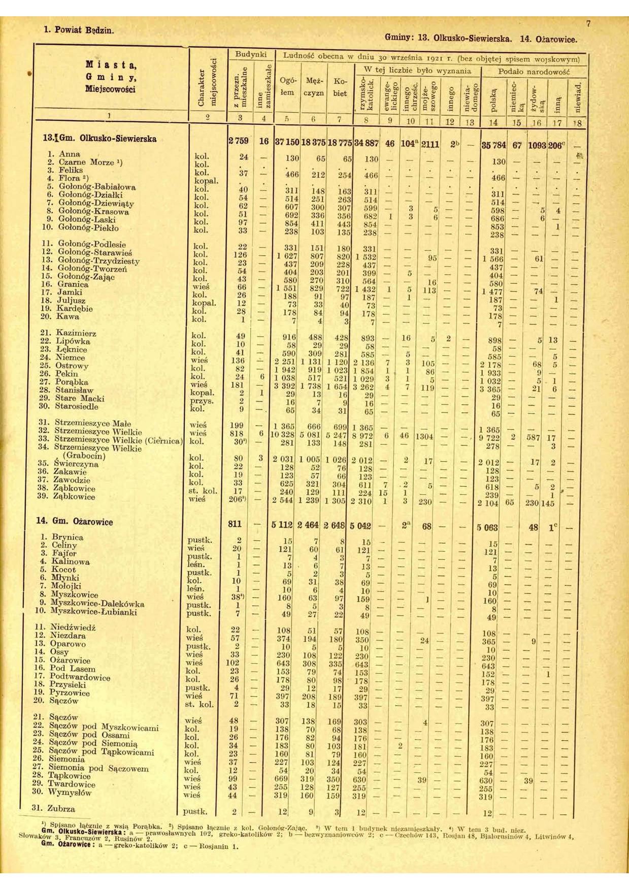
The community was first formed on January 1, 1867 in the powiat Będziński in the newly formed Petrikau governorate in the Russian-dominated Congress Poland . In 1921 it comprised 31 localities with a total of 5,112 inhabitants. It existed until 1950.
On January 1, 1973 it was set up again as Gmina Tąpkowice . The seat of the municipality was in the village of Ożarowice. On December 9, 1973 the Sołectwo Celiny was spun off from the community of Gmina Bobrowniki and incorporated into Gmina Tąpkowice, and on January 1, 1975 parts of the village of Sączów, Gmina Bobrowniki, were transferred to Gmina Tąpkowice. On January 1, 1997, the name of Gmina in Ożarowice was changed to adapt the name to local conditions.
From 1948 to 1998 Gmina belonged to the Katowice Voivodeship .
Population development
The following is a graphic representation of the population development of the municipality from 2000 to 2008.

education
The municipality has two kindergartens ( Przedszkole ), two elementary schools ( szkoła podstawowa ) and one middle school ( gimnazjum ).
Footnotes
- ↑ population. Size and Structure by Territorial Division. As of June 30, 2019. Główny Urząd Statystyczny (GUS) (PDF files; 0.99 MiB), accessed December 24, 2019 .
- ↑ regioset.pl (pl / en)
- ↑ Główny Urząd Statystyczny: Skorowidz miejscowości Rzeczypospolitej Polskiej. Tom III. Województwo kieleckie . Warszawa 1925, p. 7 [PDF: 13] (Polish, online [PDF]).
- ↑ Dz.U. 1975 no 17 poz. 92 (Polish) (PDF; 802 kB)
- ↑ Dz.U. 1996 no 155 poz. 761 (Polish)
- ↑ Dz.U. 1972 nr 49 poz. 312
- ↑ Ordinance No. XX / 99/72 Wojewódzkiej Rady Narodowej w Katowicach of December 6, 1972 (Dziennik Urzędowy Wojewódzkiej Rady Narodowej w Katowicach z dnia 20 grudnia 1972 r., No. 12, Poz. 103)
- ↑ Dz.U. 1973 nr 40 poz. 236
- ↑ Dz.U. 1991 no 115 poz. 497
- ↑ Dz.U. 1996 no 155 poz. 761
- ↑ Dz.U. 1975 no 17 poz. 92 (Polish) (PDF; 802 kB)
- ↑ Strategy paper of the municipality (Polish) (Word.doc; 2.1 MB) ( page no longer available , search in web archives ) Info: The link was automatically marked as defective. Please check the link according to the instructions and then remove this notice.
- ↑ Główny Urząd Statystyczny, "LUDNOŚĆ - STAN I STRUKTURA W PRZEKROJU TERYTORIALNYM" Status: December 31, 2008 ( Memento from June 3, 2009 on WebCite )
- ↑ Główny Urząd Statystyczny, "LUDNOŚĆ - STAN I STRUKTURA W PRZEKROJU TERYTORIALNYM", as of December 31, 2010 ( Memento of September 2, 2011 in the Internet Archive ) (PDF; 1.3 MB) ()
- ↑ Główny Urząd Statystyczny, "LUDNOŚĆ - STAN I STRUKTURA W PRZEKROJU TERYTORIALNYM", as of June 30, 2012 (accessed February 1, 2013) ( Memento from December 30, 2012 on WebCite )
- ↑ Główny Urząd Statystyczny, "LUDNOŚĆ - STAN I STRUKTURA W PRZEKROJU TERYTORIALNYM", as of June 30, 2014 (accessed February 1, 2015) ( memo from November 23, 2014 on WebCite )
Kalety (Kalet) - city | Krupski Młyn (Kruppa Mill) | Miasteczko Śląskie (Georgenberg) - town | Ożarowice (Ozarowice) | Radzionków (Radzionków) - City | Świerklaniec (Neudeck) | Tarnowskie Góry (Tarnowitz) - City | Tworóg (Tworog) | Zbrosławice (Broslawitz)