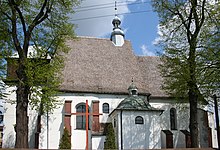
Koziegłowy
| Koziegłowy | ||
|---|---|---|

|
|
|
| Basic data | ||
| State : | Poland | |
| Voivodeship : | Silesia | |
| Powiat : | Myszków | |
| Area : | 26.72 km² | |
| Geographic location : | 50 ° 36 ' N , 19 ° 10' E | |
| Residents : | 2455 (June 30, 2019) |
|
| Postal code : | 42-350 | |
| Telephone code : | (+48) 34 | |
| Economy and Transport | ||
| Street : | E 75 Częstochowa - Sosnowiec | |
| Ext. 789 Żarki - Kalety | ||
| Next international airport : | Katowice | |
| Gmina | ||
| Gminatype: | Urban-and-rural parish | |
| Gmina structure: | 26 school offices | |
| Surface: | 159.16 km² | |
| Residents: | 14,319 (June 30, 2019) |
|
| Population density : | 90 inhabitants / km² | |
| Community number ( GUS ): | 2409023 | |
| Administration (as of 2009) | ||
| Mayor : | Jacek Ślęczka | |
| Address: | Plac Moniuszki 14 42-350 Koziegłowy |
|
| Website : | www.kozieglowy.pl | |
Koziegłowy (German historically: Coßziegle ) is a city in Poland in the Silesian Voivodeship . The city is the seat of an urban-and-rural municipality in the powiat Myszkowski .
history
The exact time when today's Koziegłowy was built is not known. From around 1106 the place was called Koziegłowy . It was created according to German law. In 1402 a parish was established in Koziegłowy. In 1472 the place in the Duchy of Siewierz received city rights according to Magdeburg law . In the Second Northern War , the place was destroyed by the Swedes. During the third partition of Poland in 1795, the city became part of Prussia , Province of Neuschlesien . In 1807 she came to the newly founded Duchy of Warsaw and in 1815 to Congress Poland . In this de facto Russian province, the place lost its town charter in 1870. At the beginning of the First World War Koziegłowy was occupied by the Germans in the summer of 1914. This lasted until the end of the war with which the place became part of the re-established Poland . At the beginning of the attack on Poland , Koziegłowy was occupied by the German Wehrmacht in September 1939 and assigned to the district of Warthenau in the new "East Upper Silesia". After the end of the Second World War , the place came back to Poland and was granted city rights again in November 1949. From 1975 the city was part of the Częstochowa Voivodeship . With a renewed reform of the administrative structures of Poland this voivodeship was dissolved and since then Koziegłowy has been part of the Silesian Voivodeship.
local community
The rural municipality Koziegłowy includes the following localities with a Schulzenamt :
- Cynków
- Gniazdów
- Gliniana Góra
- Koclin
- Koziegłówki
- Krusin
- Lgota Górna
- Lgota-Mokrzesz
- Lgota-Nadwarcie
- Markowice
- Miłość
- Mysłów
- Mzyki
- Nowa Kuźnica
- Oczko
- Osiek
- Pińczyce
- Postęp
- Pustkowie Lgockie
- Rosochacz
- Rzeniszów
- Siedlec Duży
- Siedlec Mały
- Stara Huta I.
- Stara Huta II
- Winowno
- Wojsławice
- Zabijak
Culture and sights
Buildings
- the late Gothic church of St. Magdalena from the 15th / 16th centuries century
- the baroque chapel from the second half of the 17th century
- the baroque church from 1670 with a renaissance altar
- Wooden houses from the 19th / 20th centuries century
Economy and Infrastructure
traffic
State road 1 ( droga krajowa 1 ) leads through Koziegłowy, which is also European route 75 here . It leads north to Częstochowa (20 km) and Lodz (150 km) and ends after about 500 kilometers in Danzig ( Gdańsk ). In the south, the road leads via Sosnowiec (40 km) to the Cieszyn / Český Těšín border crossing to the Czech Republic, 140 kilometers away .
The provincial road 789 ( droga wojewódzka 789 ) runs from east to west . This leads through Żarki in the east after about 15 kilometers and joins state road 46 after about 35 kilometers . In a westerly direction it runs through Woźniki after four kilometers and joins Voivodeship Road 907 after 25 kilometers near the village of Brusiek
The nearest international airport is Katowice Airport, 15 kilometers south .
Daughter of the city
- Wioletta Grzegorzewska (* 1974), poet and prose writer
Web links
- City website (Polish)
Individual evidence
- ↑ a b population. Size and Structure by Territorial Division. As of June 30, 2019. Główny Urząd Statystyczny (GUS) (PDF files; 0.99 MiB), accessed December 24, 2019 .
- ↑ https://mapy.mzk.cz/mzk03/001/036/791/2619267294/
- ↑ a b c Website of the city, Historia Miasta , February 5, 2008 ( Memento of January 2, 2009 on WebCite )
- ↑ a b c szukacz.pl, Koziegłowy - Informacje dodatkowe ( Memento of January 2, 2009 on WebCite ), accessed on January 2, 2009
- ↑ The source mapa.szukacz.pl accidentally swapped Congress Poland and the Duchy of Warsaw

