Droga krajowa 8
| Droga krajowa 8 in Poland | ||||||||||||||||||||||||||||||||||||||||||||||||||||||||||||||||||||||||||||||||||||||||||||||||||||||||||||||||||||||||||||||||||||||||||||||||||||||||||||||||||||||||||||||||||||||||||||||||||||

|
||||||||||||||||||||||||||||||||||||||||||||||||||||||||||||||||||||||||||||||||||||||||||||||||||||||||||||||||||||||||||||||||||||||||||||||||||||||||||||||||||||||||||||||||||||||||||||||||||||
| |
||||||||||||||||||||||||||||||||||||||||||||||||||||||||||||||||||||||||||||||||||||||||||||||||||||||||||||||||||||||||||||||||||||||||||||||||||||||||||||||||||||||||||||||||||||||||||||||||||||
| map | ||||||||||||||||||||||||||||||||||||||||||||||||||||||||||||||||||||||||||||||||||||||||||||||||||||||||||||||||||||||||||||||||||||||||||||||||||||||||||||||||||||||||||||||||||||||||||||||||||||
| Basic data | ||||||||||||||||||||||||||||||||||||||||||||||||||||||||||||||||||||||||||||||||||||||||||||||||||||||||||||||||||||||||||||||||||||||||||||||||||||||||||||||||||||||||||||||||||||||||||||||||||||
| Operator: |
|
|||||||||||||||||||||||||||||||||||||||||||||||||||||||||||||||||||||||||||||||||||||||||||||||||||||||||||||||||||||||||||||||||||||||||||||||||||||||||||||||||||||||||||||||||||||||||||||||||||
| Start of the street: |
Kudowa-Zdrój ( 50 ° 26 ′ N , 16 ° 12 ′ E ) |
|||||||||||||||||||||||||||||||||||||||||||||||||||||||||||||||||||||||||||||||||||||||||||||||||||||||||||||||||||||||||||||||||||||||||||||||||||||||||||||||||||||||||||||||||||||||||||||||||||
| End of street: |
Budzisko ( 54 ° 19 ′ N , 23 ° 7 ′ E ) |
|||||||||||||||||||||||||||||||||||||||||||||||||||||||||||||||||||||||||||||||||||||||||||||||||||||||||||||||||||||||||||||||||||||||||||||||||||||||||||||||||||||||||||||||||||||||||||||||||||
| Overall length: | 721 km | |||||||||||||||||||||||||||||||||||||||||||||||||||||||||||||||||||||||||||||||||||||||||||||||||||||||||||||||||||||||||||||||||||||||||||||||||||||||||||||||||||||||||||||||||||||||||||||||||||
|
Course of the road
|
||||||||||||||||||||||||||||||||||||||||||||||||||||||||||||||||||||||||||||||||||||||||||||||||||||||||||||||||||||||||||||||||||||||||||||||||||||||||||||||||||||||||||||||||||||||||||||||||||||
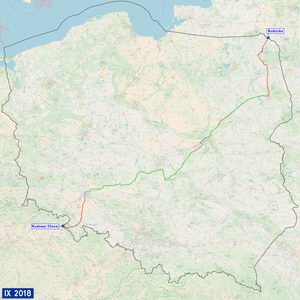
The National Road 8 (short DK8 , pol. On National Road 8 'or, country road 8') is a country road in Poland . It currently runs from the Czech- Polish border near Kudowa-Słone , where it continues the Czech Silnice I / 33 , to the Polish- Lithuanian border in Budzisko and represents a north-east-south-west axis in Polish road traffic .
In the meantime it has been replaced in many sections by the S8 expressway . Since the completion of the S8 expressway, the state road between Magnice near Wroclaw and Białystok has disappeared from the road network.
On the entire route, the national road is part of the European route 67 ("Via Baltica"), which leads from Helsinki / Finland through Estonia , Latvia , Lithuania , Poland to Prague / Czech Republic .
history
The state road was established in 1986 and connects routes with different origins.
origin
In 1827 only the short section between Warsaw and Żabia Wola had already been developed as a road . From there, the Warsaw-Czenstochauer Strasse , which was then under construction, was to be continued to Petrikau.
In the first half of the 19th century, the country roads in the Prussian provinces of Poznan and Silesia were upgraded to paved artificial roads ( Chausseen ). The road from Breslau via Glatz to Vienna was expanded between 1827 and 1833. In 1847-48 the road from Oels via Groß Wartenberg to Kempen was expanded. The road between Piotrków Trybunalski and Wieluń was also built during the same period . It enabled the textile industry to grow in Bełchatów .
Previous routes and names
The network of state roads (Polish: Drogi państwowe , singular Droga państwowa ) introduced in the Polish Road Act of December 10, 1920 included primarily those roads that led to the capital Warsaw:
- 2. Warsaw - Piotrków Trybunalski - Czestochowa
- 5. Warsaw - Ostrołęka - Łomża - Augustów - Suwałki - Lithuanian border near Kaunas
- 6. Warsaw - Zambrów - Białystok - Grodno
- 20. Piotrków Trybunalski - Wieluń - Kępno - German border near Groß Wartenberg
The network of roads established by the German Reich in 1932 comprised the following roads, which are now sections of State Road 8:
- Reichsstraße 6 from Breslau to Groß Wartenberg
- Reichsstraße 116 from Breslau to Glatz
- Reichsstraße 150 from Glatz to Bad Kudowa
The Polish state road network was originally aimed at the capital Warsaw, its street numbers were numbered clockwise from Warsaw. The road from Warsaw to Bialystok was designated as Droga państwowa 3 in 1949 , the road from Warsaw to Częstochowa as Droga państwowa 14 .
In 1985 the Polish road network was reorganized. The previous state roads (Pol .: Drogi państwowe ) were in state roads (Pol .: Drogi Krajowe , singular Droga krajowa numbered) renamed and new. In 1985 the following state roads existed on today's state road 8:
- Droga krajowa 8 from Warsaw via Wroclaw to Bad Kudowa
- Droga krajowa 18 from Warsaw via Białystok and Sokółka to the state border near Kuźnica
- Droga krajowa 19 from Białystok via Suwałki to the state border
These three sections were later joined together to form a road. With the reform of the numbering of all state roads, the current route of the state road was finally determined on May 9, 2000.
Replacement by the S8
Between 2004 and 2019, the DK8 between Wrocław and Białystok was replaced in sections by the S8 (or in the Wrocław area by the A8). Between Wrocław and Wieluń, the S8 was completely re-routed, while between Warsaw and Białystok only bypasses were re-routed and otherwise the existing route was expanded into an expressway. In the area of the newly routed sections, the old DK8 was downgraded to a voivodship road.
From Wieluń to Łódż or Piotrków Trybunalski, the route of the S8 differs significantly from the old DK8. This section of the DK8 was added to the DK74 (as DK74j) . In the urban area of Wrocław, the former DK8 is now numbered as DK98 . This means that the DK8 only consists of two sections: from Kudowa-Słone to Wrocław, and from Białystok to Budzisko.
Important places along the route
- Kudowa-Zdrój
- Duszniki-Zdrój
- Szczytna
- Polanica-Zdrój
- Kłodzko
- Bardo
- Ząbkowice Śląskie
- Łagiewniki
- Wroclaw
- Syców
- Kępno
- Wieruszów
- Wieluń
- Szczerców
- Bełchatów
- Piotrków Trybunalski
- Warszawa
- Marki
- Radzymin
- Białystok
- Augustów
- Suwałki
See also
Web links
- GDDKiA website (Polish)
- Website of the Drogi Zaufania program (Polish)
Footnotes
- ↑ Annals of geography, ethnology and national studies. Born in 1830, p. 785.
- ↑ Law of December 10, 1920 on the Construction and Maintenance of Public Roads in Poland. Dz.U. 1921 no. 6 poz. 32.
- ^ Ordinance of the Ministry of Construction of August 26, 1949 on the minimum distance between buildings on some main roads. Dz.U. 1949 no. 52 poz. 398
- ↑ Resolution No. 192 of the Council of Ministers of December 2, 1985 on the selection of state roads. MP 1986 no. 3 poz. 16.

