Droga krajowa 11
| Droga krajowa 11 in Poland | ||||||||||||||||||||||||||||||||||||||||||||||||||||||||||||||||||||||||||||||||||||||||||||||||||||||||||||||||||||||||||||||||||||||||||||||||||||||||||||||||||||||||||||||||||||||||||||||||||||||||||||||||||||||||||||||||||||||||||||||||||||||||||||||||||||||||||||||||||||||||||||||||||||||||||||||||||||||||||||||||||||||||||||||||||||||||||||||||||||||||||||||||||||||||||||||||||||||||||||||||||||||||||||||||||||||||

|
||||||||||||||||||||||||||||||||||||||||||||||||||||||||||||||||||||||||||||||||||||||||||||||||||||||||||||||||||||||||||||||||||||||||||||||||||||||||||||||||||||||||||||||||||||||||||||||||||||||||||||||||||||||||||||||||||||||||||||||||||||||||||||||||||||||||||||||||||||||||||||||||||||||||||||||||||||||||||||||||||||||||||||||||||||||||||||||||||||||||||||||||||||||||||||||||||||||||||||||||||||||||||||||||||||||||
| map | ||||||||||||||||||||||||||||||||||||||||||||||||||||||||||||||||||||||||||||||||||||||||||||||||||||||||||||||||||||||||||||||||||||||||||||||||||||||||||||||||||||||||||||||||||||||||||||||||||||||||||||||||||||||||||||||||||||||||||||||||||||||||||||||||||||||||||||||||||||||||||||||||||||||||||||||||||||||||||||||||||||||||||||||||||||||||||||||||||||||||||||||||||||||||||||||||||||||||||||||||||||||||||||||||||||||||
| Basic data | ||||||||||||||||||||||||||||||||||||||||||||||||||||||||||||||||||||||||||||||||||||||||||||||||||||||||||||||||||||||||||||||||||||||||||||||||||||||||||||||||||||||||||||||||||||||||||||||||||||||||||||||||||||||||||||||||||||||||||||||||||||||||||||||||||||||||||||||||||||||||||||||||||||||||||||||||||||||||||||||||||||||||||||||||||||||||||||||||||||||||||||||||||||||||||||||||||||||||||||||||||||||||||||||||||||||||
| Operator: |
|
|||||||||||||||||||||||||||||||||||||||||||||||||||||||||||||||||||||||||||||||||||||||||||||||||||||||||||||||||||||||||||||||||||||||||||||||||||||||||||||||||||||||||||||||||||||||||||||||||||||||||||||||||||||||||||||||||||||||||||||||||||||||||||||||||||||||||||||||||||||||||||||||||||||||||||||||||||||||||||||||||||||||||||||||||||||||||||||||||||||||||||||||||||||||||||||||||||||||||||||||||||||||||||||||||||||||
| Start of the street: |
Kołobrzeg ( 54 ° 11 ′ N , 15 ° 34 ′ E ) |
|||||||||||||||||||||||||||||||||||||||||||||||||||||||||||||||||||||||||||||||||||||||||||||||||||||||||||||||||||||||||||||||||||||||||||||||||||||||||||||||||||||||||||||||||||||||||||||||||||||||||||||||||||||||||||||||||||||||||||||||||||||||||||||||||||||||||||||||||||||||||||||||||||||||||||||||||||||||||||||||||||||||||||||||||||||||||||||||||||||||||||||||||||||||||||||||||||||||||||||||||||||||||||||||||||||||
| End of street: |
Bytom ( 50 ° 21 ′ N , 18 ° 55 ′ E ) |
|||||||||||||||||||||||||||||||||||||||||||||||||||||||||||||||||||||||||||||||||||||||||||||||||||||||||||||||||||||||||||||||||||||||||||||||||||||||||||||||||||||||||||||||||||||||||||||||||||||||||||||||||||||||||||||||||||||||||||||||||||||||||||||||||||||||||||||||||||||||||||||||||||||||||||||||||||||||||||||||||||||||||||||||||||||||||||||||||||||||||||||||||||||||||||||||||||||||||||||||||||||||||||||||||||||||
| Overall length: | 596 km | |||||||||||||||||||||||||||||||||||||||||||||||||||||||||||||||||||||||||||||||||||||||||||||||||||||||||||||||||||||||||||||||||||||||||||||||||||||||||||||||||||||||||||||||||||||||||||||||||||||||||||||||||||||||||||||||||||||||||||||||||||||||||||||||||||||||||||||||||||||||||||||||||||||||||||||||||||||||||||||||||||||||||||||||||||||||||||||||||||||||||||||||||||||||||||||||||||||||||||||||||||||||||||||||||||||||
| Development condition: | see below | |||||||||||||||||||||||||||||||||||||||||||||||||||||||||||||||||||||||||||||||||||||||||||||||||||||||||||||||||||||||||||||||||||||||||||||||||||||||||||||||||||||||||||||||||||||||||||||||||||||||||||||||||||||||||||||||||||||||||||||||||||||||||||||||||||||||||||||||||||||||||||||||||||||||||||||||||||||||||||||||||||||||||||||||||||||||||||||||||||||||||||||||||||||||||||||||||||||||||||||||||||||||||||||||||||||||
| The DK11 in Poznan | ||||||||||||||||||||||||||||||||||||||||||||||||||||||||||||||||||||||||||||||||||||||||||||||||||||||||||||||||||||||||||||||||||||||||||||||||||||||||||||||||||||||||||||||||||||||||||||||||||||||||||||||||||||||||||||||||||||||||||||||||||||||||||||||||||||||||||||||||||||||||||||||||||||||||||||||||||||||||||||||||||||||||||||||||||||||||||||||||||||||||||||||||||||||||||||||||||||||||||||||||||||||||||||||||||||||||
|
Course of the road
|
||||||||||||||||||||||||||||||||||||||||||||||||||||||||||||||||||||||||||||||||||||||||||||||||||||||||||||||||||||||||||||||||||||||||||||||||||||||||||||||||||||||||||||||||||||||||||||||||||||||||||||||||||||||||||||||||||||||||||||||||||||||||||||||||||||||||||||||||||||||||||||||||||||||||||||||||||||||||||||||||||||||||||||||||||||||||||||||||||||||||||||||||||||||||||||||||||||||||||||||||||||||||||||||||||||||||
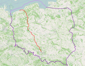
The Droga krajowa 11 (short DK11 , pol. For, national road 11 'or, national road 11') is a country road in Poland . It currently runs from Kołobrzeg to Bytom and represents a north-south axis in Polish road traffic that connects the Baltic Sea with the Upper Silesian industrial area. The total length is 596 kilometers. In some sections, the state road has now been replaced by the S11 expressway . Once the expressway is completed, it will disappear from the road network.
history
The course of the streets from Kołobrzeg and Chodzież corresponded to the route of the former German Reichsstrasse 160 . With the reorganization of the Polish road network in 1985, the state road was made up of the previous state roads 50 (Kołobrzeg − Koszalin) and 155 (Jastrowie − Piła − Chodzież − Oborniki Wlkp. − Posen) and initially ran between Kołobrzeg and Posen. With a further reform of the numbering of all state roads on May 9, 2001, the route of the state road to Bytom was extended. The route between Poznan and Bytom was previously part of state road 42 (Posen − Pleszew) and state road 43 (Pleszew − Bytom).
In 2009 the state road on the sections between Poznań and Kórnik and near Ostrów Wielkopolski was expanded to form the S11 expressway .
Traffic safety
In order to improve road safety, the Drogi Zaufania (German: "Trust Roads") program was developed by the GDDKiA . As part of this program, various traffic safety measures were taken from 2008 onwards at places with an increased risk of accidents along the state road. The implementation of a bypass is planned as part of the S11 expressway and the installation of traffic control systems .
State of development
The state of development of state road 11 is structured as follows:
| section | Stripes | Dividing strip | comment |
|---|---|---|---|
| Kołobrzeg - Koszalin | 2 | No | |
| City of Koszalin | 4th | No | urban |
| Koszalin - |
2 | No | |
| Kórnik - |
2 | No | |
| Ostrów Wielkopolski urban area | 4th | No | urban |
| Ostrów Wielkopolski - |
2 | No | |
|
|
4th | No | urban |
Important places along the route
- Kołobrzeg
- Koszalin
- Bobolice
- Szczecinek
- Okonek
- Jastrowie
- Piła
- Ujście
- Chodzież
- Rogoźno
- Oborniki
- Poznań
- Kórnik
- Środa Wielkopolska
- Jarocin
- Pleszew
- Ostrów Wielkopolski
- Antonin
- Ostrzeszów
- Kępno
- Baranów
- Byczyna
- Kluczbork
- Olesno
- Lubliniec
- Tarnowskie Góry
- Bytom
See also
Web links
- GDDKiA website (Polish)
- Website of the Drogi Zaufania program (Polish)
Footnotes
- ↑ Route of Landesstraße 11 on maps.google.de (accessed on September 8, 2014)
- ↑ Resolution No. 192 of the Council of Ministers of December 2, 1985 on the selection of state roads. MP 1986 no. 3 poz. 16.
- ^ Resolution No. 160 of the Council of Ministers of December 15, 1998 on the selection of state roads. MP 1998 no. 160 poz. 1071.
- ↑ Drogi w programie: Droga krajowa nr 11 ( Memento from September 10, 2014 in the Internet Archive ) (Polish)

