Rogoźno
| Rogoźno | ||
|---|---|---|

|
|
|
| Basic data | ||
| State : | Poland | |
| Voivodeship : | Greater Poland | |
| Powiat : | Oborniki | |
| Area : | 11.24 km² | |
| Geographic location : | 52 ° 45 ′ N , 17 ° 0 ′ E | |
| Height : | 63 m npm | |
| Residents : | 11,128 (Jun. 30, 2019) |
|
| Postal code : | 64-610 | |
| Telephone code : | (+48) 67 | |
| License plate : | POB | |
| Economy and Transport | ||
| Street : | DK 11 Oborniki - Piła | |
| Ext. 241 Rogoźno– Wągrowiec | ||
| Rail route : | Poznan – Piła | |
| Next international airport : | Poznan-Ławica | |
| Gmina | ||
| Gminatype: | Urban and rural municipality | |
| Gmina structure: | 34 localities | |
| 17 school authorities | ||
| Surface: | 217.95 km² | |
| Residents: | 18,348 (Jun. 30, 2019) |
|
| Population density : | 84 inhabitants / km² | |
| Community number ( GUS ): | 3016023 | |
| Administration (as of 2009) | ||
| Mayor : | Bogusław Janus | |
| Address: | ul. Nowa 2 64-610 Rogoźno |
|
| Website : | www.rogozno.pl | |
Rogoźno ([ rɔˈgɔʑnɔ ], German Rogasen ) is a city in western Poland , which is located in the Greater Poland Voivodeship and about 30 kilometers north of Poznan . Rogoźno is the seat of an urban and rural municipality .
history
The then Polish King Przemysław II was killed in Rogoźno on February 8, 1296 .
During the (Europe-wide) hunger crisis of 1847 , Rogasen was the scene of civil war-like unrest when Polish and Jewish lower-class members looted the homes of German and Jewish residents.
The official renaming of Rogasen in Rogoźno took place after the First World War , when, according to the provisions of the Versailles Treaty, the German Empire had to cede, among other things, large parts of the Prussian province of Posen to the re-established Polish state .
After the annexation by the National Socialist German Reich , which was contrary to international law , the town belonged - again under its German name - to the Obornik district in the Reichsgau Wartheland from 1939 to 1945 . The Reich government had a teacher training institute (LBA) and a camp of the Reich Labor Service (RAD) set up in Rogasen.
local community
In addition to the city of Rogoźno, the city and rural community includes 17 further districts ( German names up to 1945 ) with a Schulzenamt .
|
|
Other localities in the municipality are:
|
|
Attractions
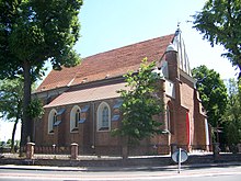
- The Roman Catholic St. Vitus Church, built in 1526.
- The town hall on the old market square Plac Karola Marcinkowskiego
- Liceum Ogólnokształcące im. Przemysła II, one of the oldest school buildings in Greater Poland, from 1869.
- Jewish cemetery by the forest from the 17th century, whose tombstones were removed during the Nazi era and used to build a new walkway.
- medieval castle
- catholic cemetery near the parish church
- destroyed evangelical cemetery at the Jezioro Rogozińskie lake
- Church of the Holy Spirit from the 19th century with a wooden bell tower
politics
coat of arms
The coat of arms shows in red half a silver eagle and a silver key and above a gold crown.
flag
The city flag of Rogoźnos has three horizontal stripes in white, gold and red. The middle gold track is twice as wide as the white and red.
traffic
The city has a train station on the Poznań – Piła railway line and the Inowrocław – Drawski Młyn railway line, which is only used for freight transport near Rogoźno .
education
- Kubuś Puchatek Kindergarten No. 1
- Kindergarten No. 2
- Primary school No. 2
- Elementary School No. 3 "Poznań Insurgents" ( "Powstańców Wielkopolskich" )
- Middle School No. 1 " Mazurek Dąbrowskiego "
- Middle School No. 2
- Middle School No. 3 at the Gymnasium (" Liceum Ogólnokształcące im. Przemysła II" )
- High School Liceum Ogólnokształcące im. Przemysła II
- Dezydery-Chłapowski - Agribusiness Vocational School
- Hipolit-Cegielski vocational school
Personalities
- Marcus Jastrow (1829–1903), rabbi in Worms, Warsaw and Philadelphia
- Cossmann Werner (1854–1918), rabbi in Danzig and Munich
- Philipp Veltman (1859–1916), politician and Lord Mayor of Aachen
- Genja Jonas (1895–1938), German photographer,
- Gerhard F. Hering (1908–1996), German journalist, director and theater director,
- Maksymilian Rode (1911–1999), bishop of the Catholic Church, publicist, peace activist
- Rudolf Bornhof (1914–1944), Lieutenant of the Wehrmacht, bearer of the Knight's Cross of the Iron Cross
Web links
- City website (Polish)
- German topographer. Map, 3267 Bülowsthal (1: 25000), edition 1 of the XI. 1944
Footnotes
- ↑ a b population. Size and Structure by Territorial Division. As of June 30, 2019. Główny Urząd Statystyczny (GUS) (PDF files; 0.99 MiB), accessed December 24, 2019 .
- ^ Hans-Heinrich Bass: Hunger crises in Prussia during the first half of the 19th century. Scripta Mercaturae Verlag, St. Katharinen 1991, ISBN 3-922661-90-4 , pp. 250-251.
- ↑ The Genealogical Place Directory
- ↑ a b c d e f g h i j k Cf. Deutsche Topograph. Map, 3267 Bülowsthal
- ↑ a b c d e f g h i j k l m n o p q Cf. Forum Ahnenforschung - German place names in the Wartheland
- ↑ Archived copy ( Memento of the original from March 6, 2017 in the Internet Archive ) Info: The archive link was inserted automatically and has not yet been checked. Please check the original and archive link according to the instructions and then remove this notice.


